
TravelNews
Live updates: Life-threatening flash flood threat targets Texas, Louisiana amid tropical trouble


1:10 PM ET Just NowBreaking News
Flash Flood Warning issued for Shreveport, Bossier City, and Marshall
The National Weather Service has issued a Flash Flood Warning for northwestern Louisiana and northeastern Texas until 3:00 p.m. CT this afternoon, as a cluster of powerful thunderstorms dumps torrential rainfall across the Ark-La-Tex region.
The immediate warning zone covers southern Caddo and southern Bossier parishes in Louisiana, as well as Harrison County in Texas.Populated areas including Shreveport, Bossier City, and Marshall are directly in the path of this high-impact flooding.
Local emergency officials are warning that rapid runoff is primed to flood creeks, streams, low-lying urban sectors, highways, and residential underpasses, potentially cutting off key commuting routes.
If you are traveling through the area this afternoon, remain highly alert to rapidly changing conditions and remember the vital, life-saving rule when encountering submerged streets: Turn Around, Don’t Drown.
1:05 PM ET 4 Min Ago
FOX Weather Threat Zone places millions on high alert for life-threatening flash floods
The FOX Weather Threat Zone has lit up this week, highlighting an expansive, high-risk corridor primed for life-threatening flash flooding across the Gulf Coast.
Millions of Americans stretching from South Texas through Louisiana and deep into Mississippi are directly in the crosshairs of this dangerous, multi-day atmospheric setup.
A plume of record-rich tropical moisture is aggressively colliding with a stalled cold front, effectively turning the sky into a relentless firehose capable of dumping widespread totals of 3 to 6 inches, with localized bullseyes threatening to see up to 15 inches of water.
FOX Weather meteorologists warn that the danger will be amplified by training thunderstorms—stationary storm cells that repeatedly track over the exact same neighborhoods.
With the highest threat levels locked in through midweek, people inside the Threat Zone are urged to treat this event with extreme seriousness, monitor live radar updates, and never underestimate the power of fast-rising floodwaters.
12:51 PM ET 18 Min AgoBreaking News
Flash Flood Warning issued for Houston as storms inundate the metro with heavy rain
The FOX Forecast Center is tracking thunderstorms moving directly through the Houston metropolitan area, unleashing heavy rain across the region.
The National Weather Service has issued a Flash Flood Warning for Houston and Harris County until 2:15 p.m. CT because the downpours are capable of producing quick ponding on area roads and slowing down local commuters.
Because atmospheric moisture levels remain incredibly high across Southeast Texas, weather conditions can change rapidly, and everyone in the metro area is strongly urged to stay weather-aware throughout the day.
11:55 AM ET 1 HR AgoBreaking News
Classes canceled and employees told to shelter in place at STC Mid-Valley campus
Flash flooding hitting the region has forced South Texas College to cancel all classes at its Mid-Valley campus until further notice.
In addition to the academic cancellations, campus officials have issued an urgent directive instructing all STC employees currently on-site to shelter in place as hazardous conditions escalate outside.
In a post on X, the college says administrators are actively monitoring the storm and will provide official updates as new information becomes available, advising the campus community to remain tuned to local weather stations and monitor STC’s social media platforms for safety announcements.
11:51 AM ET 1 HR Ago
Life-threatening Flash Flood Warning issued for southeastern Hidalgo County
The National Weather Service has issued a critical Flash Flood Warning for southeastern Hidalgo County until 1:00 p.m. CT this afternoon as relentless tropical downpours slam the area.
Doppler radar indicates that between 2.5 and 6 inches of rain have already fallen across the region, with additional rain rates of up to 1.5 inches per hour threatening to exacerbate the ongoing, life-threatening flash flooding.
Communities including Weslaco, Donna, and Mercedes are bracing for impacts, with emergency officials warning that roads, highways, and low-lying urban underpasses could rapidly become completely impassable.
10:55 AM ET 2 HRS Ago
Dangerous and life-threatening flooding slams Texas amid heavy rain
Ryan Dirker from the Waco Office of Emergency Management joined FOX Weather to talk about how his city is responding to this ongoing threat.
10:52 AM ET 2 HRS Ago
Swiftwater boat teams on standby in Austin as flood threat surges
The Austin-Travis County Emergency Management Agency in Texas confirmed that first responders successfully resolved an overnight flood incident involving a single stranded driver.
No injuries were reported from the scene, which stands as the only rescue call emergency personnel responded to last night in Austin.
Local authorities are taking no chances with this week’s flash flood threat and have officially placed specialized swiftwater boat teams on standby to respond immediately if flash flooding escalates.
10:45 AM ET 2 HRS Ago
City of Boerne shuts down all public trails as rising Cibolo Creek floods local paths
Heavy morning rain has prompted the City of Boerne in Texas to close all city trails and numerous streets until further notice due to dangerous, rising water levels.
Severe flash flooding along Cibolo Creek has sent water spilling over into several trail sections, leaving them completely submerged and unsafe for public use.
The flooding has also significantly impacted local traffic, forcing city crews to shut down multiple roadways. Among the most critical closures is Herff Road at River Road, where conditions continue to deteriorate as Cibolo Creek swells.
City personnel are actively monitoring the situation and will reopen transportation and recreational paths only after water levels have safely receded.
10:43 AM ET 2 HRS Ago
Firefighters rescue 15 stranded campers from fast-rising floodwaters in Oklahoma
A weekend camping trip turned into an emergency operation on Sunday morning when Tahlequah firefighters and multiple local agencies rushed to rescue 15 campers stranded by fast-rising floodwaters in Oklahoma.
The group was caught off guard at Littlefields at Spring Creek, located just outside of the Peggs community in northern Cherokee County.
Law enforcement personnel arriving first on the scene determined that the campers were completely trapped by the encroaching water, requiring rescue boats to safely navigate to the campsite, which sat an estimated quarter of a mile away from the nearest accessible county road.
The rescue quickly became a highly coordinated, multi-agency effort as Tahlequah firefighters joined emergency responders from Peggs, the Grand River Dam Authority (GRDA), Illinois River, and Locust Grove at a central staging area.
Crews successfully launched rescue boats into the turbulent waters to reach the isolated site.
Thanks to the swift and seamless collaboration among the various departments, all 15 campers were safely transported back to the staging area with no injuries reported.
Click here to see the full Facebook post from the Tahlequah Fire Department.
10:29 AM ET 2 HRS Ago
More than 25 million Americans under flood alerts from Texas to Mississippi
The sheer scale of the dangerous weather setup gripping the Deep South is coming into focus this morning, with more than 25 million Americans currently under some type of flood alert.
The massive zone of concern stretches all the way from South Texas, across most of Louisiana, and well into Mississippi.
10:16 AM ET 2 HRS AgoDeveloping Story
NWS Houston issues urgent warning for rare flood risk as record moisture takes aim
The National Weather Service office in Houston has issued a stark warning this morning as a dangerous weather pattern begins to take shape over Southeast Texas.
Meteorologists warn that the atmosphere is primed to become exceptionally optimized for rain efficiency through late in the workweek.
Morning forecast soundings reveal a textbook setup for deluge conditions: precipitable water (PWAT) values approaching a staggering 2.3 to 2.6 inches. These moisture values skyrocket well past the 90th climatological percentile, even shattering daily records for this time of year.
A dangerous weather pattern is beginning to take shape over SE Texas early today with hazardous weather conditions anticipated through late in the work week.
– National Weather Service Houston/Galveston, Texas
As a cold front drifts south and stalls, it will act as a relentless lifting mechanism to unleash widespread showers and thunderstorms today.
The threat escalates significantly into Tuesday and Wednesday as an atmospheric “X-Factor” enters the picture—a trough of low pressure currently over northeastern Mexico drifting toward the Texas coastal bend.
Even if this low fails to undergo official tropical development, its interaction with the record-rich airmass has historically produced catastrophic rain.
Because of this, the Weather Prediction Center has placed the region under a rare “moderate risk” (level 3 out of 4) for excessive rain, forecasting widespread totals of 3 to 8 inches with blinding rainfall rates of 2 to 4 inches per hour—and up to 5 inches per hour possible near the coast.
Meteorologists emphasize that a “moderate risk” is a seldom-issued, high-impact designation, pointing out the chilling reality that roughly 1 out of 5 historical flood fatalities occur during these specific risk days.
10:08 AM ET 3 HRS Ago
Flooding causes significant road damage and prompts multiple water rescues in Sisterdale
The Sisterdale Volunteer Fire Department in Texas is reporting significant damage to local roads after torrential floodwaters ripped through the area this morning.
Emergency crews remain actively deployed across the Sisterdale region, responding to a dangerous string of multiple incidents involving both vehicles and individuals who have become stranded in rising low-water crossings.
9:48 AM ET 3 HRS AgoBreaking News
Flash flooding leaves multiple roads underwater and impassable at Keesler Air Force Base
The relentless flash flood threat impacting coastal Mississippi has prompted road closures inside Keesler Air Force Base in Biloxi.
Base officials report that torrential downpours have left multiple roadways entirely underwater and completely impassable to traffic.
Personnel and residents on the installation are being urged to avoid all non-essential travel and remain weather-aware as emergency crews monitor the rising waters across the base.
9:43 AM ET 3 HRS Ago
Tremendous rain threatens a broad swath from Houston to Corpus Christi today
The stage is set for a day of tremendous, highly dangerous rain along the Texas Gulf Coast as two distinct atmospheric features collide directly over the region.
Flooding downpours are currently surging south toward the coast, meeting a massive plume of abundant tropical moisture that is flowing directly north off the warm waters of the Gulf of America.
This powerful convergence is expected to unleash relentless, heavy rain across a vulnerable corridor stretching all the way from Houston through Victoria and down to Corpus Christi, with FOX Weather meteorologists warning that rapid urban and flash flooding will remain an immediate threat throughout the day.
9:27 AM ET 3 HRS Ago
Torrential rain swamps coastal Mississippi with severe flash flooding this morning
Flash flooding has hit coastal Mississippi this morning, prompting alarming reports from the Biloxi area.
Torrential downpours have completely inundated local neighborhoods, with water levels reportedly reaching halfway up to neighborhood mailboxes in some severely impacted areas.
Some roads from Biloxi through Saint Martin are currently submerged under 1 to 2 feet of standing water, making travel extraordinarily hazardous.
Local authorities are pleading with commuters to stay off flooded residential streets and main thoroughfares as infrastructure struggles to handle the immense runoff.
9:06 AM ET 4 HRS Ago
Analysis: Why the brewing Gulf disturbance is unlikely to earn an official tropical name this week
While a firehose of tropical moisture is poised to trigger historic flooding across the Deep South, the FOX Forecast Center notes that the system is highly unlikely to organize into Tropical Depression One or Tropical Storm Arthur this week.
The primary reason for this lack of development stems from the system’s current structure and its immediate environment.
The main upper-level area of circulation remains heavily disorganized and tucked over land in northeastern Mexico, which severely limits its ability to tap into the warm ocean waters needed to build a traditional tropical core.
Furthermore, as the disturbance attempts to edge toward the northwestern Gulf of America by midweek, it faces highly hostile atmospheric roadblocks. Unfavorable environmental conditions, including strong upper-level wind shear and pockets of dry air, are expected to tear at the system, preventing it from wrapping into a cohesive, symmetrical tropical cyclone.
June disturbances historically struggle against these early-season inhibitors, meaning the National Hurricane Center maintains a very low probability for development.
However, forecasters reiterate that whether the system receives a name or not has no bearing on its danger—the threat of catastrophic rain remains entirely unchanged.
9:01 AM ET 4 HRS Ago
Texas Department of Public Safety issues stark warning as vehicles stand stranded on I-35
The Central Texas Department of Public Safety is issuing a stark warning to drivers as first responders conducted rescue operations on southbound Interstate 35 between Waco and Hewitt overnight.
Multiple vehicles became completely stranded in deep floodwaters between mile markers 330 and 327, triggering massive traffic delays while crews work to safely clear the roadway.
8:49 AM ET 4 HRS Ago
Pinned
Analysis: Why this “no-name” storm could catch millions off guard with historic Gulf Coast flooding
The FOX Forecast Center is warning that a dangerous sense of complacency could leave millions of residents along the Texas Gulf Coast vulnerable to a catastrophic flooding event this week.
Because the chances of this system organizing into a named tropical storm or depression remain exceptionally low, many residents may assume the threat is minor.
However, history has repeatedly proven that “no-name” systems—unbound by the strict definitions of a tropical cyclone—can be just as devastating as a named hurricane when it comes to rainfall.
By focusing solely on wind speeds or a lack of a storm name, communities from Houston to Galveston risk being caught completely off guard by the sheer magnitude of what is coming.
The physical reality on the ground is that this type of unnamed storm carries the exact same water hazards as a major tropical system. Right now, an upper-level area of circulation is pulling near-record levels of Pacific and Gulf moisture directly into a stalled cold front.
This atmospheric alignment is acting as a relentless firehose, poised to dump an unbelievable 8 to 12 inches of rain over the region through much of the workweek.
Without the psychological trigger of a Tropical Storm Warning to prompt evacuations or emergency preparations, normal morning commutes can rapidly transform into life-threatening situations.
People must look past the lack of a name and recognize that the extreme Level 3 out of 4 flash flood threat facing the Texas and Louisiana coastlines is a high-end emergency demanding immediate readiness.
8:38 AM ET 4 HRS Ago
Driver trapped on I-35 near Waco shares terrifying encounter with fast-rising flash floods
A driver trapped on Interstate 35 near Waco is expressing profound gratitude this morning after narrowly escaping a terrifying flash flood ordeal on the highway.
Rick Smith recounted the harrowing experience of watching floodwaters fiercely cascade over a nearby retaining wall, noting how easily the situation could have turned into a horrible tragedy had the structure failed.
8:34 AM ET 4 HRS Ago
Overnight deluge dumps more than seven inches of rain across the Texas Hill Country
A powerful overnight deluge has left a massive swath of Central Texas waterlogged this morning, with the FOX Forecast Center recording eye-popping rain totals in the Texas Hill Country.
Isolated locations have already tracked more than 7 inches of rain since Sunday night, instantly overwhelming local creeks and drainage systems.
8:29 AM ET 4 HRS Ago
Catastrophic flash flood threat looms as historic rain totals target Houston and Galveston
The FOX Forecast Center is raising alarms over a truly staggering amount of tropical moisture targeted at the Gulf Coast region this week. Meteorologists are now projecting widespread rainfall totals of 8 to 12 inches to fall along the Texas Gulf Coast, with the extreme deluge stretching eastward across the entirety of Louisiana and deep into Mississippi.
The highest concerns are centered squarely on the major metropolitan hubs of Houston and Galveston, where these projected double-digit rain totals could trigger catastrophic flash flooding. Because local soils are already heavily saturated from previous weeks of stormy weather, any additional downpours will immediately turn into dangerous runoff.
8:18 AM ET 4 HRS Ago
Flash flooding on Highway 90 triggers massive San Antonio traffic delays
Flash flooding has overwhelmed US Highway 90 near Cupples Road in the San Antonio area.
Torrential rain has sent high water spilling directly across multiple lanes of the highway, bringing the morning commute to a halt.
Bumper-to-bumper delays are rapidly backing up for miles as eastbound drivers are forced to brake or divert away from the inundated highway.
8:11 AM ET 4 HRS Ago
Flash flooding swamps the Texas Hill Country and major metro areas
The FOX Forecast Center has received multiple reports of water rescues and flash flooding across Texas this morning.
Torrential rain has quickly translated into hazardous conditions on the ground. In the city of Austin, just under two dozen low-water crossings have already been closed to traffic due to rising waters.
The intensity of the deluge is further evidenced by Shoal Creek at 12th Street, which rapidly rose to a crest near 9 feet.
Farther south, the situation is equally critical as heavy downpours inundate the San Antonio area.
A trained spotter reports water is covering all four lanes of US Highway 90 at Cupples Road, severely impacting travel.
The flooding has turned life-threatening in Helotes, located on the northwest side of San Antonio, where numerous stranded vehicles and active water rescues are currently ongoing.
8:01 AM ET 5 HRS AgoDeveloping Story
Deep South faces days of potentially catastrophic flooding from a firehose of tropical moisture
The FOX Forecast Center is tracking an escalating and highly dangerous weather setup that places millions of residents across the Deep South at risk for widespread, locally catastrophic flash flooding this workweek.
Confidence continues to grow that a relentless firehose of moisture will soak the region through at least Thursday, prompting the issuance of rare Level 3 out of 4 flood threats day after day.
Major metro hubs including Houston, Corpus Christi, and Jackson, Mississippi, are all squarely in the crosshairs to face this high-end deluge at some point over the coming days.
The danger is being driven by a combination of atmospheric ingredients acting as a perfect storm for excessive rain.
Deep tropical moisture surging north out of the Gulf is colliding with a strong cold front dropping south. This boundary is expected to stall completely by midweek, creating an ideal tracks for slow-moving, repeating thunderstorms to dump immense amounts of rain over the exact same waterlogged communities.
At the same time, an upper-level area of circulation—packing the atmospheric remnants of former Eastern Pacific Tropical Storm Cristina—is moving out of Mexico and tapping into near-record atmospheric moisture levels.
Even if this broad area of low pressure never achieves official tropical storm status in the northwestern Gulf, FOX Weather meteorologists stress that the severe flooding threat remains identical.
Saturated soils from previous weeks of rain mean that immediate runoff is a certainty.
Flood Watches already blanket virtually all of South Texas, the middle and upper Texas coasts, the entire state of Louisiana, and western Mississippi.
The Houston Metro alone faces a staggering three consecutive days under a Level 3 out of 4 flood risk beginning Monday.
TravelNews
Mayor Mamdani reveals details on Knicks ticker-tape parade down Canyon of Heroes to City Hall


MANHATTAN (WABC) — Mayor Zohran Mamdani on Sunday revealed new details about Thursday’s ticker-tape parade for the Knicks, fresh off their first title in 53 years.
The parade is scheduled to start at 10 a.m. near Battery Park and travel north along Broadway through the Canyon of Heroes before concluding at City Hall.
Mamdani will host a championship celebration and Key to the City ceremony on the City Hall Plaza immediately after the parade.
“As a fan, I haven’t wanted to jinx it, but as the mayor, we’ve been preparing for all these logistics,” Mamdani told ABC 7.
He also said that the Knicks reflect the never-give-up spirit of the city.
MORE: New York City celebrates the NBA Champion Knicks
“I was reading a piece this morning that wrote about often times in our city’s history, this kind of unity comes in a moment of tragedy, and it’s so beautiful that this unity is coming from a moment of joy,” he said.
The mayor previously announced that City Hall and municipal buildings across the city will be illuminated in blue and orange on the night of Thursday, June 18 in recognition of the victory.
Buildings confirmed to be lit include the David N. Dinkins Manhattan Municipal Building at 1 Centre Street and Brooklyn Borough Hall at 209 Joralemon Street. Additional city buildings may also participate in the tribute.
The celebration will mark the first ticker-tape parade in Knicks history.
Live Blog: The drought is over! Knicks win first NBA title in 53 years
———-
* Get Eyewitness News Delivered
* More New York City news
* Send us a news tip
* Download the abc7NY app for breaking news alerts
* Download our connected TV app
Submit a tip or story idea to Eyewitness News
TravelNews
South Bay resident with measles visited SFO airport, San Jose locations


A South Bay resident with measles may have exposed others when visiting the San Francisco International Airport and two locations in San Jose this week, health officials said Saturday.
The Santa Clara County Public Health Department said its staff is working with the California Department of Public Health and the Centers for Disease Control and Prevention to identify close contacts who were exposed to measles during the infectious period.
The department said in a news release Saturday that the person with measles is an adult who was exposed during international travel. The department did not say whether the person was vaccinated against the virus.
On Monday, June 8, the contagious individual visited San Francisco International Airport’s International Terminal — including passport control, customs and the international baggage claim area — between 8:30 a.m. to 11 a.m., the agency said, and also went to Trader Joe’s on Coleman Avenue and the International Halal Market on E Santa Clara Street between 8 p.m. to 10 p.m.
Members of the public who visited the sites at those times on June 8 may be at risk of developing measles seven to 10 days after they were exposed, the department said. Officials also warned that any unvaccinated individual traveling or joining large gatherings should be aware of their increased risk of measles if exposed.
The department advised any individual who may have been affected to review their immunization records and call their healthcare provider immediately if they are pregnant, have a weakened immune system or are not immunized. They should monitor symptoms for seven to 21 days after the potential exposure.
If symptoms develop, the agency urged anyone who believes they may be infected to call ahead to any medical facility before arriving and tell them about the exposure.
The department also urged anyone with measles or at risk of developing measles not to attend large gatherings, as measles “is one of the most infectious diseases in the world and spreads very rapidly.”
“Given the number of large international events currently happening throughout the Bay Area, it is especially important that any unvaccinated, exposed individual quarantines to the best of their ability and avoids contact with others if feeling unwell,” the department said.
In February, the department warned of the first confirmed measles case since May 2025, when a Santa Clara County resident with measles visited a Panda Express restaurant in Burlingame while infected. Prior to 2025, the last confirmed case of measles in a Santa Clara County resident was in 2019.
Common symptoms of measles include fever, cough, runny nose, red eyes, and a rash, which can appear seven to 21 days after the exposure, the agency said.
The two-shot measles, mumps and rubella vaccine series is 97% effective at preventing measles if a person is exposed and cases are typically milder in vaccinated people.
According to the CDC, the virus may infect a vaccinated person if their immune system didn’t respond correctly to the vaccine, or if they were near someone with the virus for a long time. Disease symptoms are generally milder in vaccinated people and vaccinated individuals are less likely to spread the disease to others, according to the CDC.
The Santa Clara County Public Health Department said the Bay Area region benefits from very high rates of vaccination against measles.
“Exposures like this one remind us of the importance of vaccination. Fortunately, the Bay Area region has strong community immunity, because of our very high rates of vaccination or from childhood exposure decades ago,” said Dr. Sarah Rudman, Health Officer and Public Health Director for the County of Santa Clara. “Two shots of MMR or MMRV vaccine continue to be the best protection against measles and can stop a measles outbreak in its tracks, which is especially important during times of gathering and travel.”
TravelNews
Ebola disease caused by Bundibugyo virus, Democratic Republic of the Congo & Uganda

Situation at a glance
The Bundibugyo virus disease (BVD) outbreak in the Democratic Republic of the Congo continues to evolve rapidly, with increasing case numbers and geographic spread. As of 10 June, a cumulative of 676 confirmed cases, including 136 deaths, have been reported from the Democratic Republic of the Congo. As of 11 June, Uganda has reported 19 confirmed cases including two deaths, as well as one probable case who has died. In Uganda, the outbreak remains epidemiologically linked to transmission originating in the Democratic Republic of the Congo, with evidence of both imported infections and secondary transmission among contacts and healthcare workers. Uganda has not reported any new cases in the past six days. National authorities in the two affected countries, in collaboration with WHO and partners, are implementing a comprehensive package of response measures. A regional preparedness and prioritization framework continues to guide readiness activities across the African Region.
Description of the situation
Since the last Disease Outbreak News was published on 8 June 2026, the number of confirmed cases and deaths have increased rapidly in the Democratic Republic of the Congo. In total, 695 confirmed cases; 676 from the Democratic Republic of the Congo and 19 from Uganda; and 138 deaths including two from Uganda, have been reported from both countries, while at least 37 people have recovered from the disease.
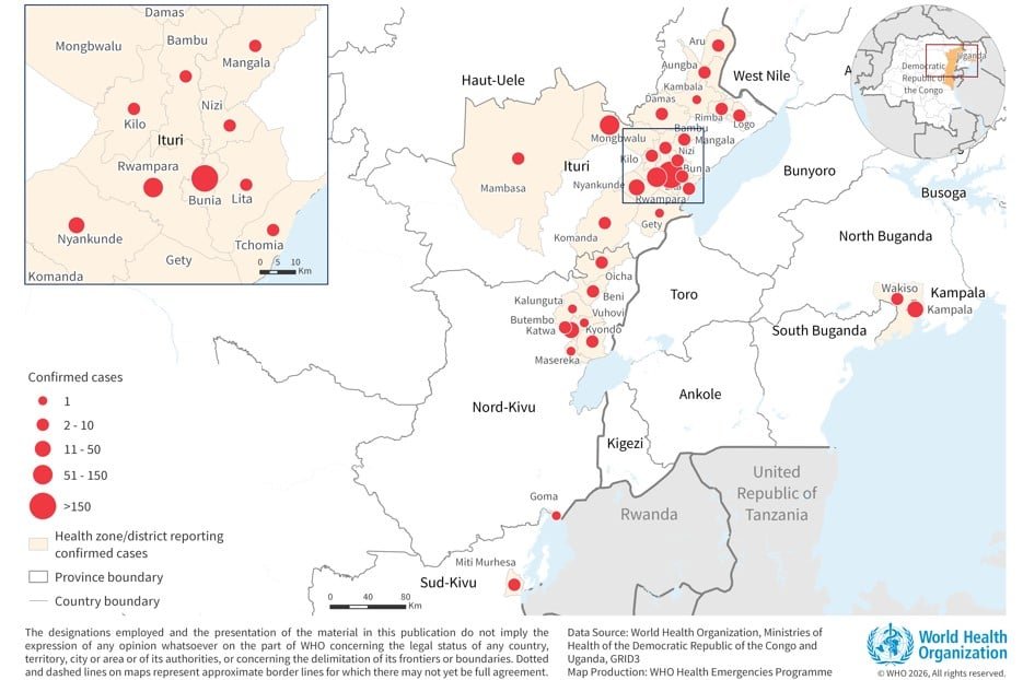
Figure 1. Distribution of confirmed cases of Bundibugyo virus disease in the Democratic Republic of the Congo, as of 10 June; and Uganda, as of 11 June
Democratic Republic of the Congo
Since 8 June, an additional 161 confirmed cases, including 45 confirmed deaths, have been reported from the Democratic Republic of the Congo. The increase is in part due to the scale up of testing and diagnostic capacities, enabling testing of the backlog of previously collected samples. As of 10 June 2026, a total of 676 confirmed cases including 136 deaths (CFR 20.1%) have been reported from the Democratic Republic of Congo. The reported CFR is likely an underestimation, as many deaths that occurred before the outbreak declaration remain under investigation. So far, 32 patients have recovered. Cases have been reported from 29 health zones (HZ) from Ituri (19/36 HZ), North Kivu (9/35 HZ) and South Kivu provinces (1/34 HZ) [1]. Sixteen confirmed cases have been reported among health and care workers to date.
The outbreak remains concentrated in Ituri Province, which accounts for 93% (629) of the confirmed cases with a CFR of 17.3% (109/629). The highest number of confirmed cases in Ituri Province are reported from Bunia (185 cases), Rwampara (137 cases), Mongbwalu (132 cases), and Nyankunde (33 cases) health zones. While the epicentre remains Ituri, there has been significant geographic expansion of health zones with confirmed cases since 8 June, with confirmed cases in additional four health zone as of 10 June. Of the total confirmed cases, 94 are awaiting distribution by HZ.
As of 10 June, 5768 contacts have been identified and are under follow-up across Ituri (4703), North Kivu (841), and South Kivu (224) provinces. Of these, 4141 contacts have been followed up, corresponding to follow-up rates of 71.4% in Ituri, 71% in North Kivu, and 83.5% in South Kivu.
The outbreak is unfolding in a complex humanitarian and conflict-affected environment, characterized by highly mobile and often displaced populations. These dynamics, combined with increasing security-related incidents affecting health facilities, have posed additional operational challenges in affected provinces, such as constrained access for response teams, disrupted surveillance and response activities, and heightened risk of undetected transmission. These conditions underscore the need for response efforts to be led by local leaders and anchored in communities.
Figure 2: Number of confirmed cases (n = 676) in the Democratic Republic of the Congo, by date of reporting as of 10 June 2026
NB: Newly reported confirmed cases/deaths may be part of the back log of samples and therefore not necessarily newly acquired infections.
Uganda
Since the last update dated 8 June, no additional confirmed cases or death have been reported from Uganda. As of 10 June 2026, a cumulative of 19 confirmed cases including two deaths in imported cases, and one probable case who has died, have been reported. Of the confirmed cases, 14 cases are imported and five are secondary transmission among contacts and health workers following cases imported from the Democratic Republic of the Congo. The cases have been reported from two districts, Kampala and Wakiso, both part of the Kampala Metropolitan Area. To date, there has been no documented community transmission in Uganda. Exposure risks are associated with healthcare settings and cross-border movements. Five recoveries have been reported to date.
Of the 820 contacts listed as of 11 June, a total of 409 contacts are under active follow up and 394 contacts have completed their 21-day follow-up period.
Figure 3: Number of confirmed cases (n = 19) in Uganda by date of reporting as of 11 June 2026
Epidemiology
Bundibugyo virus disease (BVD) is a severe and often fatal form of Ebola disease caused by the Bundibugyo virus, one of the Orthoebolavirus species. It is a zoonotic disease, with fruit bats suspected to be the natural reservoir. Human infection is thought to occur through close contact with the blood or secretions of infected wildlife, such as bats or non-human primates, and it subsequently spreads from person to person through direct contact with the blood, secretions, organs, or other bodily fluids of infected individuals or contaminated surfaces or items. Transmission is particularly amplified in health-care settings when infection prevention and control (IPC) measures are inadequate, and during unsafe burial practices involving direct contact with the deceased.
The incubation period for BVD ranges from two to 21 days, and individuals are not infectious until symptom onset. Early symptoms such as fever, fatigue, muscle pain, headache, and sore throat, are non-specific, which complicates clinical diagnosis and can delay detection. These symptoms then progress to gastrointestinal symptoms, organ dysfunction, and in some cases haemorrhagic manifestations. Case fatality rates in the past two BVD outbreaks, reported in Uganda and in the Democratic Republic of the Congo in 2007 and 2012 were 30% and 50% respectively.
Differentiating BVD from other endemic febrile illnesses such as malaria is challenging without laboratory confirmation using PCR or antigen/antibody-based assays. Control relies on rapid case identification, isolation and care, contact tracing, safe burials, and strong community engagement, as no approved vaccines or specific treatments currently exist for BVD.
Public health response
Health authorities in the Democratic Republic of the Congo and Uganda, in collaboration with WHO and partners, are implementing comprehensive public health measures including implementing the continental response plan, engaging donors and mobilizing additional resources to address critical funding gaps and sustain response operations across affected and at-risk areas.
In the Democratic Republic of the Congo, a subnational risk-stratification analysis has been conducted to further inform the operational response priorities. According to the latest analysis dated 8 June, 159 health zones are categorized as affected or at risk. This underscores the massive geographic scale of response needed to control this outbreak
For further information about public health response actions by the respective Ministry of Health, WHO, and partners, please refer to the latest situation reports published by the WHO Regional Office for Africa Ebola Bundibugyo Virus Disease Outbreak Democratic Republic of the Congo | Uganda Weekly External Situation Report 04, Data as of 7 June 2026 | WHO | Regional Office for Africa
Following the recommendations of WHO advisory groups on candidate therapeutics to be considered for a clinical trial, WHO, Africa CDC and other partners are supporting the Democratic Republic of the Congo and Uganda in implementing the clinical trial. This include using MBP134 and REGN3479 for treatment, and using obeldesivir for post-exposure prophylaxis, ensuring the highest ethical standards under the leadership of the national health authorities and in close consultation with affected communities.
The protocol for the trial has been submitted and is under review by ethics committees and regulatory authorities of the countries. More coordination, and research and development funding, are needed to ensure timely access to candidate therapeutics.
WHO risk assessment
On 6 June 2026, WHO reassessed the risk of the outbreak of BVD to incorporate newly available information and align with the WHO Temporary Recommendations. The risk for countries sharing land borders with countries with documented Bundibugyo virus (BVDV) detection, currently the Democratic Republic of the Congo and Uganda, has been separated out from the risk for other countries in the African Region.
The risk in the Democratic Republic of the Congo remains assessed as very high due to ongoing transmission and the continued expansion of the outbreak into new health zones, increasing the potential for further national and regional spread.
The risk in Uganda is still assessed as high due to confirmed cross-border spread through imported cases and ongoing epidemiological links along the eastern Democratic Republic of the Congo–western Uganda corridor, historically affected by Ebola outbreaks, including Bundibugyo and Sudan virus disease outbreaks.
The risk for countries with land borders adjoining countries with documented BDBV detection, is assessed as high due to sustained population mobility linked to cross-border trade and mining activities, variation in capacities and experience of BVD response, and variable levels of readiness.
The risk for the rest of the Africa region and at the global level is assessed as low.
For further information, please see the WHO Rapid Risk Assessment – Ebola disease caused by Bundibugyo virus, Democratic Republic of the Congo, Uganda and countries with land borders adjoining countries with documented BDBV detection v3.
WHO advice
WHO advises against any restriction of travel to, or trade with, the Democratic Republic of the Congo or Uganda based on the currently available information. WHO continues to closely monitor and, where necessary, verify travel and trade measures in relation to this event.
For further information on the considerations for implementing border health and international travel-related temporary recommendations, please see the relevant technical note issued on 26 May 2026.
The temporary recommendations issued to State Parties on 22 May 2026 underscore the importance of coordinated outbreak control, enhanced cross‑border collaboration, and sustained surveillance and preparedness to prevent further regional spread and ensure an effective public health response.
WHO has convened several technical advisory groups, including the Strategic Advisory Group of Experts on Immunization (SAGE) to assess candidate vaccines and therapeutics for BVD. Key recommendations made are available in the news release published on 28 May 2026.
Regular Information products on the outbreak of BVD in the Democratic Republic of the Congo and Uganda
Daily update: Epidemiological update on BVD outbreak in Democratic Republic of the Congo and Uganda
Published every Tuesday: Weekly External Situation Report on Ebola Bundibugyo Virus Disease Outbreak, Democratic Republic of the Congo | Uganda
Published every Thursday: Disease Outbreak News | All Hazards Public Health Events, Ebola disease caused by Bundibugyo virus, Democratic Republic of the Congo
Further information
TravelNews
Seven fights on the South Lawn: Trump prepares for UFC birthday spectacle at White House


There may be swarms of bugs, rain showers and thunderstorms, but this isn’t Exodus, or the apocalypse: the president of the United States will host the Ultimate Fighting Championship (UFC) at the White House on Sunday, his 80th birthday.
The iconic South Lawn – typically used by presidents to board Marine One on their way to summits, funerals and wars – has been blanketed by an octagon, ringed by thousands of seats in a mini coliseum, and dominated by a 92ft, 600-ton steel structure organizers have nicknamed “the Claw”, not unlike the alien tripods from the 2005 film War of the Worlds.
A tennis court was built at the White House in 1902. There are not one, but two, bowling alleys. Barack Obama added a basketball court in 2009. But never before has a major professional sporting event been staged on the grounds of 1600 Pennsylvania Avenue.
The extraordinary event was the idea of Trump himself, according to UFC president Dana White, reinforcing the president’s ties with a league which has amassed an enormous fanbase around a core demographic of young men. But critics have called it a blood sport.
The spectacle has been tightly controlled, with stands packed with US armed forces members required to meet strict weight-to-height and fitness specifications.
Trump is shrewd about what his fans – the Maga base which sent him back to the White House in November 2024 – wants to see, according to biographer Gwenda Blair. “They want to see this anti-elite, anti-upper-crust, anti-upper-class event,” she said. “It’s on the White House lawn? That is rubbing everybody’s face in it. It’s a version of bragging.”
As workers erected scaffolding and vendor tents on the lawn this week, the final countdown to “UFC Freedom 250” was somewhat overshadowed by ominous weather forecasts, and a legal bid to block the event from taking place altogether.
UFC has never before staged a fully outdoor event in its 33-year history. The one previous outdoor attempt, a 2010 show in Abu Dhabi, was held in a venue that was at least partially covered. This one has no roof at all.
The National Weather Service forecast for Sunday evening currently shows a “likely” chance of thunderstorms in Washington DC right around the time the main event begins. UFC has two meteorologists on site, drawing from two separate data sources, filing weather updates every hour.
All the while, a lawsuit filed last weekend by the watchdog group Public Integrity Project sought an emergency injunction. The suit argues the administration erroneously relied on a rule meant for federally organized commemorations of the nation’s 250th anniversary to justify an event that, by White’s own admission, was Trump’s idea. A judge ultimately denied the request on Friday.
The complaint had also pointed to Trump’s financial disclosures, which showed that the president bought up to $50,000 in stock in TKO Group Holdings, the UFC’s parent company, earlier this year.
The administration pressed on, undeterred – championing what it pitched as the UFC’s virtues, from drug testing to diplomacy.
At the White House media day on Wednesday, Sara Carter, a former Fox News contributor now serving as director of the Office of National Drug Control Policy, presented Derrick “The Black Beast” Lewis – one of Trump’s favorite UFC fighters – with recognition for 75 consecutive clean drug tests, and declared him to be an example for children everywhere.
Lewis thanked her, before telling reporters that he didn’t have anything against drugs, generally, but marijuana every now and then helps him out. If anyone wanted to give him a medal for it, he said, he’d take it.
A day later, Marco Rubio, the US secretary of state, signed a memorandum of understanding establishing a public-private partnership between the state department and the UFC. Rubio called the promotion the “United Nations of fighting”, arguing that a UFC crowd is one of the few places left where people from different backgrounds gather around something they share. The administration signed a similar memorandum with the NFL earlier this year.
The focus now turns to Sunday night’s proceedings: seven fights on the South Lawn. The main event pits undefeated lightweight champion Ilia Topuria, from Spain, against the interim champion Justin Gaethje, from the US, in a unification bout. The co-main event, between Alex Pereira and Ciryl Gane, will crown an interim heavyweight champion. Lewis will also feature.
About 4,300 people are expected in the stands, including about 1,200 seats set aside for active-duty military personnel. Those seats came with conditions. According to a Pentagon memo reviewed by Military Times, service members selected for tickets were required to meet a waist-to-height ratio of 0.55 or below, and pass their service-specific physical fitness standards. The memo also called for “genuine UFC fans”, and made clear troops would cover their own travel costs.
But not everyone got through the door. Sean Strickland, the only active American men’s UFC champion, says he was told the White House had not cleared him to attend, a decision he attributed to comments he made criticizing Trump, Israel and Jeffrey Epstein. (White denied that Strickland, who has a history of making racist, sexist and homophobic comments, was banned.)
The remaining tickets will go to the president, UFC leadership and a long list of donors, lobbyists and members of US Congress angling for seats near the cage.
Whether the weather cooperates remains to be seen. But barring a badly timed thunderstorm, under the lights, the White House will stage an event without precedent, at the behest of the president.
David Smith contributed reporting
TravelNews
My Paternal Instinct Should’ve Warned Me About Netflix’s Maternal Instinct


I went into Netflix‘s Maternal Instinct with no sense of what I was about to watch. Really, I only even pulled up the screeners to stop one of the documentary’s producers from asking me a fifth time if I’d watched. So I went to my Preview Content hub, selected the film without so much as a thumbnail, and dove in. (Well, I did so after I got the authentication code sent to my cell phone, keyed it in… you don’t need all the details.)
Almost immediately, I regretted the decision. To be clear, that feeling is not an indictment on the quality of the film — it’s solely a reflection of the subject matter. Being a parent didn’t help matters here.
In Maternal Instinct, directed by Jessica Dimmock (HBO’s Thoughts & Prayers, Hulu’s Captive Audience) and executive produced by Liz Garbus (I”ll Be Gone in the Dark, Gone Girls: The Long Island Serial Killer), a young woman from a wealthy family falls in love with an East Texas hog trapper. Classic girl meets boy stuff, just with a trailer full of pigs sold for slaughter. The swine are not the only ones who will be slaughtered.
“Their relationship appears perfect and within months she’s pregnant and proudly showing off her baby bump all over social media,” the film’s official synopsis reads. “But when a state trooper pulls her over and discovers she has just given birth in her car, her story quickly falls apart.”
And that’s just the beginning. Maternal Instinct slowly plays its way to “exposing the truth behind a terrifying and unthinkable crime,” it continues.
I didn’t see the “unthinkable crime” coming — not by a mile. Either the story didn’t travel 1,369 miles to these, here parts (suburban New Jersey), or I’m simply bad at keeping up with the news. It’s probably a little bit of both, and yes, I recognize the latter is not great coming from a journalist. Cutting myself some slack, even Netflix describes the crime at the center of the story as being “relatively unknown.”
I won’t spoil it, though that’s probably not the right term here. Maybe it’s more like I won’t horrify you. Don’t Google “Taylor Parker” if you don’t want to know how this all plays out — or if you simply want to keep your lunch down.
Maternal Instinct is a tough watch but a well-made documentary; Dimmock doesn’t give away the (pecan) farm all at once. It was a purposeful creative choice, she tells The Hollywood Reporter, one that she says “in some ways is the closest thing that mirrors what happened to the victim and the victim’s family.” Her film takes its time getting from its shocking opening to its even more shocking conclusion, but when the end finally informs the beginning, you’ll realize just how “terrifying” the truth is.
Dimmock, too, was unaware of Parker’s crimes before being approached to direct. It was first-time documentary producer Samantha DeMaria who brought the story to Story Syndicate.
“Her instincts, that this was just something really out of the ordinary, were really switched on,” Dimmock said, “because she got this in her claws and wouldn’t let it go.”
The same can be said for Dimmock once she got her hands on the subject matter. I asked the true crime producer if this is “the worst story [she’s] ever heard,” which would be saying something, given the genre she works in. “Pretty much,” she responded.
“It’s hard to compare tragedies, because every time, for whoever is involved, it is the worst thing,” Dimmock added. “I don’t want to make light of anything else, but there’s a cruelty to this.”
That’s an understatement. Maternal Instinct is streaming now on Netflix.


Why is the UK banning social media for children? | BBC Newscast
Today, the prime minister has announced under-16s will be banned from social media. Speaking at Downing Street Keir Starmer …


'Volnado' spotted during Kīlauea eruption in Hawaii
A "volando" was seen swirling next to lava fountains during the Kilauea volcano's latest eruption on Hawaii's Big Island.


Fan bikes 1,200 miles to watch Japan play World Cup game
Yuto, a 22-year-old student from Japan studying in the US, decided to bike his way from Pittsburgh to Dallas to...


Iranian-Americans face complicated World Cup
CNN's Julia Vargas Jones spoke with players on Arya FC, a Los Angeles-based mostly Iranian rec league soccer team, about...


G7 'family photo' moment
G7 leaders participate in an official greeting and 'family photo' to start the annual summit. The meeting at the French...


'No f**king judgment': Trump blasts Netanyahu for Lebanon strike
President Donald Trump was enraged with Israeli Prime Minister Benjamin Netanyahu for striking Beirut hours before the …


Trump says Strait of Hormuz will be 'completely opened' Friday
While President Donald Trump was meeting with French President Emmanuel Macron, he said the Strait of Hormuz would be …


"I never thought this day would come", students finish GCSEs. #GCSE #Exams #BBCNews


West Wilson Not Returning to ‘Summer House’ Next Season
West Wilson’s run on “Summer House” is coming to an end … ’cause TMZ has learned he won’t be returning...


White House refuses to condemn UFC fighter who smeared Michelle Obama
UFC fighter Josh Hokit insulted former first lady Michelle Obama at Sunday's UFC Freedom 250 event. When asked about Hokit's...
-

 LifestyleNews2 weeks ago
120 minutes of strength training per week may help extend lifespan
-

 Business2 days ago
How much of Musk’s wealth comes from government help? Virtually all of it
-

 Politics4 days ago
What to know about the stabbing that set off fiery riots in Northern Ireland
-

 Video3 days ago
Download fans say what they love about the festival. #DownloadFestival #BBCNews
-

 Video3 days ago
Why SpaceX IPO isn't about space. #SpaceX #ElonMusk #BBCNews
-

 HealthNews3 days ago
The people of Okinawa, Japan only eat until they are about 80 percent full, then stop — and the practice has been linked in multiple peer-reviewed studies to lower rates of cardiovascular disease, slo
-

 TravelNews3 days ago
My Paternal Instinct Should’ve Warned Me About Netflix’s Maternal Instinct
-

 Food3 days ago
Pope Leo’s plane was grounded. Then the King of Spain stepped in to help