
Tech
A prototype differential atom interferometer for fundamental physics

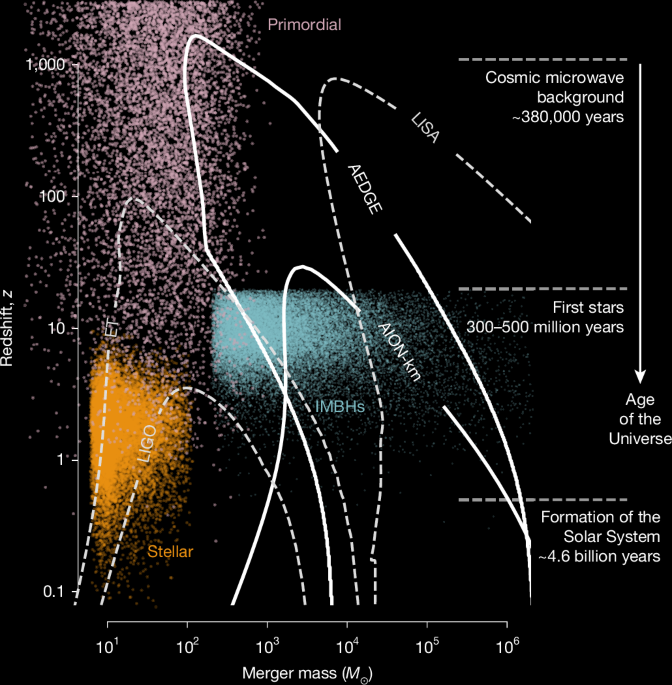
The discovery of gravitational waves by the LIGO and Virgo laser-interferometer experiments10 has opened a new window on the Universe, with prospects for breakthroughs in fundamental physics, astrophysics and cosmology. Just as observations of electromagnetic waves over a wide range of frequencies have provided insights into physical processes within and beyond our Galaxy and in the primordial Universe, it is expected that observing gravitational waves over a wide range of frequencies will offer complementary insights into an equally rich spectrum of phenomena. The operating terrestrial laser-interferometer detectors—LIGO, Virgo and KAGRA—are sensitive to gravitational waves at frequencies around 101 Hz to 103 Hz (refs. 5,11,12), and the Laser Interferometer Space Antenna experiment, now under construction, will be most sensitive to gravitational waves with frequencies around 10−4 Hz to 10−1 Hz (ref. 6), leaving unexplored an intermediate range of frequencies around 10−1 Hz to 101 Hz.
Important sources of gravitational waves in this frequency range are mergers of intermediate-mass black holes that are heavier than those detected by ground-based laser interferometers and lighter than those targeted by the Laser Interferometer Space Antenna. Such intermediate-mass black holes are thought to be the building blocks for the supermassive black holes13 at the hearts of most galaxies, so measurements of their mergers using long-baseline atom interferometers14,15 could reveal how supermassive black holes are formed16. Further, observations of the slowly evolving inspiral stages of solar-mass mergers would be possible for days or weeks instead of seconds, which would enable multi-messenger astronomy by pinpointing the locations of gravitational-wave sources in the sky17.
Atom interferometers, which use lasers to split and recombine the wavefunctions of atoms, have optimal sensitivities to gravitational waves with frequencies \({\mathcal{O}}(1)\)Hz (refs. 1,2) and, hence, are well suited to explore the frequency gap between terrestrial and space-borne laser interferometers, as seen in Fig. 1. With the gradiometer configuration shown in Fig. 2, a differential, single-photon, pair of atom interferometers separated by a baseline L of approximately 1 km could have sufficient sensitivity to detect gravitational waves18,19 with frequencies of approximately 1 Hz, which, at present, cannot be measured. Such detectors are also sensitive to theorized interactions between atomic constituents and bosonic dark matter fields with masses of approximately 10−15 eV (ref. 8), with potential resolution significantly beyond that of existing experiments1.
Long-baseline atom interferometers are under development by the Atom Interferometer Observatory and Network (AION)1 and the Matter-wave Atomic Gradiometer Interferometric Sensor (MAGIS)2 collaborations and other projects worldwide20. These join other proposed approaches in the mid-frequency band, including space-based laser interferometers such as DECIGO21 and magnetically levitated superconducting test masses22. See ref. 23 for a review. Realizing the potential of atom-interferometer experiments will require overcoming many technical obstacles to reach the target sensitivity. One open question for these projects is whether the laser phase noise, which introduces noise on each individual atom interferometer that is orders of magnitude higher than the standard quantum limit (SQL; Methods), will cancel sufficiently in the gradiometer configuration to reach the SQL. Although the gradiometer principle has previously been demonstrated in experiments using 88Sr (ref. 24)—or 87Rb (refs. 25,26), to within known limitations27—in this work we quantify the extent of noise cancellation afforded by the scheme. We do this with the more demanding fermionic isotope 87Sr, the hyperfine structure and millihertz-linewidth clock transition of which considerably complicate laser cooling and atom interferometry28,29,30,31,32. Despite these complications, 87Sr is a natural choice for gravitational-wave detection, thanks to its near-ideal properties as an atomic clock isotope33 and 150-s excited-state lifetime34. These qualities are not shared by other candidate species, such as 87Rb or 88Sr, but are essential for very-long-baseline experiments, and they enable the extension to space-scale baselines, as proposed by the Atomic Experiment for Dark Matter and Gravity Exploration (AEDGE) project4. The same differential measurement configuration that enables gravitational-wave detection with 87Sr also provides sensitivity to ultralight dark matter, which would induce coherent oscillations in the clock transition frequency across the detector baseline8.
We describe how the AION project has tested a gradiometer configuration in the laboratory using 87Sr, combining atomic clock technology with atom interferometry to form two macroscopically separated interferometers interrogated by a common clock laser. Our prototype detector reached the SQL, even in the presence of several radians of synthetic laser phase noise, which emulates the conditions of a full-scale detector. Our results imply laser noise cancellation consistent with full common-mode rejection to within the measurement resolution of our experiment. Finally, we show that the same differential configuration allows the recovery of coherent time-dependent signals, even under conditions where a single interferometer would retain no recoverable phase information. Although further work will be essential to demonstrate laser phase noise cancellation with larger numbers of atoms (for which the SQL is lower) and at longer baselines where the effects of wavefront propagation become relevant, our work verifies the principles underpinning long-baseline, single-photon atom interferometry and passes an important milestone on the road towards measurement of gravitational waves.
Analogously to the interference of light in a laser interferometer, such as that used in the LIGO, Virgo and KAGRA experiments, atom interferometry relies on the interference of quantum matter waves. In the search for gravitational waves, both techniques probe a long baseline whose length in the proper detector frame is modulated by a gravitational wave, which converts the variations in the time of flight of light along this baseline to a variation of the phase in an interference measurement (Fig. 2). For a discussion in a fully relativistic framework, see refs. 35,36. In laser interferometers, the interference is between light beams that travel along different paths. In atom interferometers, the interference is between the wavefunctions of atoms that are manipulated by laser pulses to follow spatially separated paths before recombination.
In a single-photon atom interferometer, the atomic wavefunction is manipulated using pulses of light that drive a single-photon transition in the atom, often referred to as a clock transition. For the pulse sequence shown in Fig. 3, the phase of a single interferometer can be written in the simplified form
$$\phi ={\int }_{-\infty }^{\infty }{\omega }_{0}\,g(t)\,{\rm{d}}t+{\phi }_{\mathrm{laser}}+{\phi }_{\mathrm{other}},$$
(1)
where ω0 is the angular frequency of the atomic clock transition, ϕlaser represents the total phase imprinted on the atoms due to the laser phase during pulses and ϕother comes from various sources, such as static background gravitational or electromagnetic fields2,19,35,37, which do not play a role in the dark matter or gravitational wave detection. g(t) is determined by the relative states of the upper and lower arms of the interferometer:
$$g(t)=\left\{\begin{array}{cl}-1, & \mathrm{for}\,t\,\mathrm{between}\,\mathrm{the}\,\text{first beam splitter pulse and}\\ & \text{the mirror pulse},\\ +1, & \mathrm{for}\,t\,\mathrm{between}\,\mathrm{the}\,\text{mirror pulse and the final}\\ & \text{beam splitter pulse},\\ 0, & \mathrm{otherwise}.\end{array}\right.$$
(2)
In long-baseline atom interferometry, a fundamental physics signal is extracted by taking the difference in phase δϕ = ϕtop − ϕbottom between two atom interferometers separated by a long distance. To visualize the sensitivity of δϕ to gravitational waves, the atom interferometers can be conceptualized as atomic clocks that are sensitive to small changes in the time taken for light to traverse the baseline38. The clocks ‘tick’ while gtop(t) and gbottom(t) are non-zero. These intervals are defined by the arrival times of the light pulse at each interferometer, so a modulation of the baseline L by a gravitational wave alters the time counted by the clocks. Alternatively, ultralight dark matter may cause small oscillations in the atomic energy levels, which affect the tick rate ω0 differently due to the time delay between the two interferometers8,39,40,41. An important technical advantage of taking a differential measurement is that the noise in the laser-induced phase ϕlaser cancels in common mode: without laser noise cancellation, it would be unfeasible to achieve the ultimate target phase resolution of 10−5 rad/\(\sqrt{{\rm{Hz}}}\) in the detector1, even when using extremely low-noise lasers (Methods).
Our tabletop prototype of a long-baseline atom-interferometer detector is illustrated in Fig. 3. We operate a pair of crossed optical dipole traps, separated vertically by 1 mm. The traps contain clouds of fermionic 87Sr atoms at a temperature of approximately 2 μK loaded from a narrow-linewidth magneto-optical trap (MOT; see Methods for details). When the two clouds are released into free fall, an ultrastable clock laser (described in ref. 42) addresses the 1S0 → 3P0 optical clock transition. A first pulse (not shown) selects the slowest atoms from the falling clouds, and a sequence of three pulses then splits, reflects and recombines the selected atoms to create two simultaneous Mach–Zehnder atom interferometers43. After the first beam-splitter pulse, we apply another, horizontal laser pulse, off-resonant from the 1S0 → 3P1 transition, to induce a controllable Stark shift ϕStark to just one of the interferometers (Methods). The same Stark-shifting pulse is applied in every shot of the experiment, which biases the phase offset between the interferometers to aid the data analysis.
To gather the datasets presented in Fig. 4, we scanned the relative phases of the three clock pulses applied to both atom interferometers. Figure 4a shows the typical interference fringes that we obtained. Using a π-pulse duration of 44 μs and a free-fall time of T = 200 μs between pulses, interferometer contrasts of 0.81 and 0.84 were observed. To simulate the effect of laser phase noise on a long-baseline atom interferometer, we injected randomized phase steps into the clock laser between pulses of the atom-interferometer sequence for one of the datasets. This simulated the effect of a laser phase error that accumulates during the sequence, although it neglects its effect on the fidelity of mirror pulses. This is a reasonable representation of a long-baseline detector, as laser noise will be integrated over drop times of many seconds1, thus amplifying its impact relative to our short sequence of 200 μs (see Methods for a calculation). The resulting individual interference fringes are shown in the bottom panel of Fig. 4a. They are completely obscured by the injected noise. However, the differential phase δϕ of the two interferometers can still be recovered using a maximum-likelihood analysis44 applied to the correlated excitation fractions from both interferometers. The likelihood model treats the shot-to-shot common phase as a nuisance parameter, which is marginalized (Methods). A Lissajous correlation plot (Fig. 4b) provides a visualization of the common-mode correlation.
To measure the effect of laser noise on the stability of the differential-phase measurement, we compared measurements with the same applied differential phase ϕStark, but with different levels of applied laser noise. We gathered a low laser noise (LLN) dataset in which only the intrinsic noise of the ultrastable clock laser was present42 and a high laser noise (HLN) dataset, which had several radians of laser phase noise artificially added to each shot. The LLN and HLN data were interleaved shot-by-shot, giving a total of 56,623 shots taken over 61.9 h. We extracted from each dataset a time series of the differential phase δϕ(ti) using an unbinned maximum-likelihood analysis that operated on blocks of 141 excitation measurements from both. In contrast to geometric ellipse fitting of binned Lissajous figures45, the maximum-likelihood analysis exhibited negligible bias and reduced statistical error, remaining robust even in the fully phase-randomized regime. Figure 4c shows the Allan deviation46 of these datasets; despite laser noise that completely obscures individual interferometer fringes, we observed no statistically significant increase in the differential-phase noise σδϕ beyond the Cramer–Rao SQL7,47 of σδϕ = 43.5(16) mrad per shot, determined by the 3,100(210) and 2,040(160) atoms measured in the top and bottom traps (Methods). Extrapolating to the full experimental run of 56,623 shots, split between the HLN and LLN datasets, we projected a SQL of \({\sigma }_{\langle {\rm{\delta }}\phi \rangle }=258(10)\,\mathrm{\mu rad}\) in the average differential phase \(\langle {\rm{\delta }}\phi \rangle \) for either dataset.
To quantify this rejection, we use the maximum-likelihood analysis to infer the noise levels of the measured δϕ time series in both cases. Extrapolating to the whole datasets, we determined that the standard deviations \({\sigma }_{\langle {\rm{\delta }}\phi \rangle }\) of δϕ are consistent with the SQL in both the LLN dataset and the HLN dataset, with \({\sigma }_{\langle {\rm{\delta }}{\phi }_{\mathrm{LLN}}\rangle }-{\sigma }_{\langle {\rm{\delta }}{\phi }_{\mathrm{SQL}}\rangle }=2(16)\,\mathrm{\mu rad}\) and \({\sigma }_{\langle {\rm{\delta }}{\phi }_{\mathrm{HLN}}\rangle }-{\sigma }_{\langle {\rm{\delta }}{\phi }_{\mathrm{SQL}}\rangle }=16(17)\,\mathrm{\mu rad}\) (Fig. 4c, inset). Crucially, we observed no statistically significant increase in noise, despite the addition of several radians of shot-to-shot laser phase noise in the HLN dataset, with \({\sigma }_{\langle {\rm{\delta }}{\phi }_{\mathrm{HLN}}\rangle }-{\sigma }_{\langle {\rm{\delta }}{\phi }_{\mathrm{LLN}}\rangle }=14(19)\,\mathrm{\mu rad}\), consistent with zero additional differential-phase noise within the uncertainty, despite the completely scrambled interferometer phases.
In addition to the Cramer–Rao SQL, we validated the statistical performance of the estimator (bias and coverage) at the SQL using Monte Carlo simulations matched to the experimental conditions (Methods). The Monte Carlo band shown in Fig. 4c is not a fit to the Allan deviation data: it is a prediction constructed from the statistics for the independently measured number of atoms and interferometer contrasts and processed through the same phase-extraction pipeline as the real data. Its agreement with the measured Allan deviation therefore constitutes a non-trivial closure test of the statistical model and is consistent with SQL-limited operation.
Beyond the extraction of a constant differential phase used to quantify the laser noise cancellation, the same maximum-likelihood framework, used in an unbinned mode but with time-dependent δϕ, enabled hypothesis testing for oscillatory signals in the differential measurement. This provided a proof-of-principle that physically relevant signals—such as those expected from gravitational waves or ultralight dark matter—can be extracted in a differential atom-interferometer configuration under conditions where signal recovery would be impossible using a single interferometer alone. Crucially, this signal-fitting approach remained effective in the shot-to-shot phase-randomized (HLN) regime: a single atom interferometer contained no recoverable phase information in this regime, whereas the differential measurement retained statistically recoverable sensitivity to coherent signals through common-mode noise rejection.
In Fig. 5, we tested this directly with controlled signal injection and recovery under fully phase-randomized conditions. We injected controlled sinusoidal phase modulations through the off-resonant Stark shift ϕStark applied to the top interferometer. We analysed the resulting excitation fraction record with the same unbinned likelihood model but applied over the whole dataset. Defining \({\rm{\delta }}\phi (t)={\rm{\delta }}{\phi }_{0}+A\,\sin (\omega t+\chi )\), we demonstrate signal recovery at representative test frequencies spanning the range 10−4 Hz to 10−1 Hz, with results shown in Fig. 5. These are compared with the signal recovery of a perfect, noiseless detector limited only by integration time, with excellent agreement. These frequencies lie within the measurement bandwidth of the present prototype, set by the shot cycle time of approximately 3 s and the total run duration (hours to approximately 1 day). This choice reflects the prototype operating conditions rather than a fundamental limitation of the method; in a future long-baseline detector, the sensitive band would be shifted by design through the interrogation time, baseline and repetition rate into the mid-frequency regime.
We also tested amplitude recovery by probing signals at a fixed frequency of either 1 mHz or 100 mHz, for various amplitudes (Fig. 5b). We verified that the recovered modulation amplitude scaled linearly with the applied Stark-shift duration and used this nominal calibration to seed 106 Monte Carlo simulations for each scenario to understand the sensitivity of our detector, assuming that there was no noise other than the SQL. All signals were recovered with SQL-limited resolution, and they correctly favoured the null hypothesis when no signal was present.
All signal-injection experiments were performed in the HLN regime, which emulated the behaviour of a long-baseline detector. We found that the differential channel yielded a statistically significant recovery of injected signals, fully rejecting laser phase noise in the signal recovery.
The successful integration of clock transition techniques with atom interferometry is an important milestone on the path towards their joint implementation in quantum sensors with applications in fundamental physics. These include not only the detection of ultralight dark matter and gravitational waves1,2,9 but also tests of equivalence principles48,49 and measurements of the fine structure constant50. The construction of long-baseline detectors will also spur advanced quantum sensing with applications in navigation, geodesy and resource exploration (see, for example, ref. 26).
There are many further technical hurdles to be overcome before a long-baseline detector can be realized. These include the development of more intense sources of cold atoms, the extension to longer baselines while controlling the associated systematic shifts2,37, large momentum transfer from the laser to the atoms51 and the use of squeezed atomic states47. All of these are the subjects of R&D programmes in several groups within the international Terrestrial Very-Long-Baseline Atom Interferometry Proto-Collaboration20. Nevertheless, the experimental techniques already demonstrated here open up exciting new avenues for scientific exploration that range from probing the fundamental laws that govern our Universe to enhancing quantum sensors.
Cooling sequence
The cold-atom apparatus used in this experiment has previously been described in refs. 42,56. To prepare samples of cold 87Sr, the atoms are first collected over 1.5 s in a blue three-dimensional MOT that uses the 1S0 → 1P1 transition at 461 nm and a field gradient of 3.5 mT cm−1. Atoms that leak into the metastable 3P2 manifold are recycled into the MOT using repump lasers at 679 nm and 707 nm. For efficient repumping of 87Sr, frequency sidebands at 585 MHz and 487 MHz are applied to the 707-nm light using an electro-optic modulator to create frequency components near-resonant with transitions from all five hyperfine manifolds of 3P2 (ref. 57).
When the blue MOT is switched off, the atoms are captured in a red MOT operating on the 1S0 F = 9/2 to \({}^{3}P_{{1}}\,{F}^{{\prime} }=11/2\) transition at 689 nm, using a field gradient of 390 μT cm−1. Sidebands at 1,463.265 MHz are applied to the 689-nm light using a resonant electro-optic modulator, such that the F = 9/2 to \({F}^{{\prime} }=9/2\) transition stirs the atoms between Zeeman sublevels of the ground state, thus mitigating losses into sublevels where atoms are weakly confined28. During the first 220 ms in the red MOT, an intensity of 1,800Isat is used for each of the six MOT beams, where Isat = 3 μW cm−2 is the saturation intensity of the 689-nm transition. To capture the wide range of Doppler-shifted atoms released from the blue MOT, a sawtooth-wave modulation is applied to the 689-nm light at a sweep frequency of 20 nm and a peak-to-peak sweep range of 6 MHz (ref. 58). For the following 100 nm, while in the ‘narrowband’ red MOT, the sawtooth frequency modulation is switched off and the intensities of the six MOT beams are ramped linearly from 490Isat to 40Isat. To help support the atoms against the force of gravity, a seventh, unbalanced MOT beam—the ‘up’ beam—is introduced in the vertical direction during the narrowband MOT. The up beam is necessary for creating narrowband red MOTs below 100Isat without causing significant atom loss. Upon completion of the narrowband red MOT, the atoms have a temperature of 2 μK and are compressed into a region comparable in size with the optical dipole trap.
Dipole trap and state preparation
Two crossed optical dipole traps, separated vertically by 1 mm, are formed by separate 2.5-W horizontal beams at 1,064 nm with horizontal and vertical 1/e2 radii of 220 μm and 23 μm, respectively, crossed with a shared 840-mW vertical beam at 813 nm with 1/e2 radii of 60 μm in both transverse axes. Overlapping with the top crossed dipole trap, a 4-mW transparency beam at 488 nm, detuned by 25 GHz from the 5s5p 3P1 → 5s5d 3D2 transition, is applied with a 1/e2 radius of 40 μm to protect the atoms from scattered 689-nm light after they are loaded into the top crossed dipole trap region.
Immediately after the free-space red MOT stages described above, the dipole trapping beams, the transparency beam and repumpers at 679 nm and 707 nm are switched on; the red MOT is then held for 100 ms in a ‘top-trap loading’ stage, during which the bias magnetic fields, beam intensities and detunings of the red MOT are optimized to load the atoms into the upper of the two dipole traps. During the top-trap loading stage, the red MOT intensity is linearly ramped from 20Isat to 4Isat to steadily reduce the atom temperature. Next, to load the bottom optical dipole trap, the red MOT is released for 3 ms by switching off the 689-nm beams. During this time, the cold atoms already in the top trap are held in place, while the hotter atoms fall towards the bottom trap. While the atoms are falling, the vertical bias magnetic field is stepped such that the zero of the quadrupole magnetic field is close to the bottom dipole trap. After 3 ms of free fall, the red MOT beams are switched back on for 100 ms in a ‘bottom-trap loading’ stage using the same parameters as the top-trap loading stage, except for the different bias magnetic field. All but the hottest atoms in the top trap remain in the top trap during the bottom-trap loading stage, as they are protected by the 488-nm transparency beam against scattered 689-nm light.
After both dipole traps are loaded, the MOT beams are switched off, a horizontal bias field is applied and the trapped atoms are optically pumped into the stretched state MF = 9/2 by applying a horizontal bias field of 38 μT and delivering a 20-ms pulse of circularly polarized light at 689 nm, resonant with the 1S0 F = 9/2 to 3P1 \({F}^{{\prime} }\) = 9/2 transition. During the optical pumping, sawtooth-wave frequency modulation is applied to the 689-nm light at a rate of 30 kHz over a range of 6 MHz. Finally, all beams except the dipole trap are switched off, and the bias magnetic field is adiabatically ramped to the final field used for atom interferometry: 31 μT aligned with the linear polarization of the vertical 698-nm clock beam.
Velocity selection on the clock transition
The clock beam at 698 nm propagates vertically upwards through both dipole trap regions with a waist of 600 μm. The clock laser linewidth is verified against an independent cavity-stabilized laser to ensure that it is below 2 Hz before delivery of the light to atoms through an uncompensated 10-m fibre42. Clock spectroscopy sequences are carried out immediately after atoms are released from both dipole traps. The excitation fraction is detected using a 200-μs fluorescence pulse at 461 nm to detect the number of atoms in the ground state 1S0, which is followed by 3.5-ms repumping pulses at 679 nm and 707 nm and another 200-μs fluorescence pulse at 461 nm to detect atoms that are in the 3P0 state after the interferometer sequence. Scattered light from each 461-nm spectroscopy pulse is gathered in separate exposures of an electron-multiplying charge-coupled device (EMCCD) camera (Andor iXon Ultra 897), and a separate EMCCD image without atoms present is used to subtract background counts.
At the maximum available clock power of 640 mW, a Rabi π-pulse time of 44 μs is measured. However, the clock transition was observed to have a peak excitation fraction of 0.3 and a Doppler-broadened linewidth of 60 kHz, which is considerably larger than the 20-kHz Fourier limit. To improve the fidelity of the Rabi pulses in the atom-interferometer sequence, a velocity selection procedure is used. The clock beam is pulsed on for 200 μs at 20 mW, which implements a π pulse that excites the slowest atoms to the upper clock state 3P0. The atoms in the ground state are then pushed away using a 500-μs pulse at 461 nm, leaving only the slow atoms in the 3P0 state to enter the interferometer sequence. After this velocity selection sequence, a resonant, 44-μs Rabi π pulse yielded a peak de-excitation fraction of 90%.
Clock atom interferometry
The clock atom interferometry consists of a sequence of three resonant pulses on the 698-nm clock transition, with pulse areas π/2 − π − π/2, a π-pulse time tπ = 44 μs and a dark time T = 200 μs between each consecutive pulse. For the data in Fig. 4, the phase of the clock light is always stepped deterministically during the dark times such that the phases of the first, second and third pulses are 0, ϕ and 4ϕ, respectively, with ϕ ranging from 0 to 2π in 100 steps in a randomized order. Each data point in the right-hand side of Fig. 4 is the result of 2 × 100 samples, interleaved between HLN and LLN samples. For the HLN samples, extra phase steps were applied during the interferometer dark times (Fig. 3). The HLN samples were drawn independently from a Gaussian distribution with a standard deviation of 4π rad and mean of 0 rad.
It is important to distinguish between the two types of randomization employed in this work. For both the LLN and HLN datasets, the clock laser phase is scanned deterministically through 100 values in randomized order; this scan-order randomization ensures that any spurious time-oscillatory signals, such as 50 Hz from room lights, are not aliased to look like apparent fringes. For the HLN dataset, we additionally applied large, uncorrelated phase jumps between shots, which fully randomize the absolute phase of each individual interferometer on a shot-by-shot basis. This per-shot phase randomization mimics the regime expected in long-baseline atom interferometers, where integrated laser frequency noise over multi-second interrogation times will produce phase excursions of many radians (see ‘Laser phase noise estimate for a kilometre-scale detector’ section). Under these conditions, a single atom interferometer retains no recoverable phase information, so this provides a stringent test of the noise rejection capability of differential measurements. The phase randomization fully masks the fringes in each individual interferometer but does not affect the measurement of the relative phase of the two interferometers.
Laser phase noise estimate for a kilometre-scale detector
The phase noise imparted onto the atoms by the laser can generally be calculated from the spectral density of the frequency fluctuations in the laser beam59. In our prototype, the laser phase imprinted on each atom interferometer in one repetition of the interferometer sequence beginning at time t is approximately ϕlaser = φ(t) − 2φ(t + T) + φ(t + 2T), where φ(t) is the time-dependent phase of the laser field oscillating as \(\cos (kz-{\omega }_{0}t+\varphi (t))\). This approximation holds in the limit of short beam-splitter and mirror pulses separated by a dark time T (ref. 35). Treating φ(t) as a stationary noise process with a one-sided power spectral density Sφ(f) and applying the optical Wiener–Khinchin theorem60, we observe a variance in the interferometer laser phase:
$$\begin{array}{l}\langle {\phi }_{\mathrm{laser}}^{2}\rangle \,=\,\langle {(\varphi (t)-2\varphi (t+T)+\varphi (t+2T))}^{2}\rangle \\ \,=\,6\langle \varphi (t)\varphi (t)\rangle -8\langle \varphi (t)\varphi (t+T)\rangle +2\langle \varphi (t)\varphi (t+2T)\rangle \\ \,=\,{\int }_{0}^{\infty }{S}_{\varphi }(f)[6-8\,\cos (2{\rm{\pi }}fT)+2\,\cos (4{\rm{\pi }}fT)]\,{\rm{d}}f.\end{array}$$
For a future long-baseline atom interferometer, we model the clock laser as a thermal-noise-limited, cavity-stabilized laser61 with a flicker frequency noise spectrum of the form \({S}_{\varphi }(f)={S}_{\varphi }(f=1\,{\rm{Hz}})\times {(1{\rm{Hz}}/f)}^{3}\). Propagating this functional form through the above equation, the standard deviation of the interferometer laser phase simplifies as \(\sqrt{\langle {\phi }_{\mathrm{laser}}^{2}\rangle }=4{\rm{\pi }}T\sqrt{\mathrm{ln}(2)}\sqrt{{S}_{\varphi }(1\,\mathrm{Hz})}\). To provide an optimistic numerical estimate of the laser phase, we assume a laser noise spectrum at the limit of current laser technology, with fractional frequency noise Sy(f) = (10−33/f)/Hz (ref. 62). For the 87Sr clock transition at 698 nm, the corresponding noise spectral density of the clock laser phase fluctuations would be \(\sqrt{{S}_{\varphi }(1\,{\rm{Hz}})}\) = 14 mrad/\(\sqrt{{\rm{Hz}}}\), resulting in a standard deviation for the interferometer laser phase \(\sqrt{\langle {\phi }_{{\rm{laser}}}^{2}\rangle }=710\,{\rm{mrad}}\) for T = 5 s, the interferometer time projected for a kilometre-scale detector1. Even for an interferometer repetition rate of several shots per second, the laser phase noise imprinted on each individual interferometer is, therefore, far above the level needed to reach the ultimate target phase resolution of \(1{0}^{5}\,{\rm{rad}}/\sqrt{{\rm{Hz}}}\) (ref. 1), highlighting the need for laser noise cancellation in the differential phase δϕ.
Compounding the requirements for laser phase noise cancellation, a large momentum transfer of n ≈ 104 photon recoils is targeted for long-baseline detectors1, which enhances detector sensitivity but imprints laser phase noise n times onto each atom interferometer35. Taking into account the large momentum transfer, long-baseline interferometers will probably be in the fully phase-randomized regime explored by the HLN dataset in this work.
Differential bias phase
To induce a consistent relative phase offset between the top and bottom atom interferometers, another, horizontal 689-nm Stark-shifting pulse is applied to only the top interferometer for 30 μs during the gap between the first π/2 pulse and the middle π pulse. The Stark-shifting beam is detuned by −80 MHz from the 1S0 F = 9/2 to 3P1 F′ = 11/2 transition, with a waist of 500 μm and a power of 1 mW, which induces a phase shift specifically on atoms in the ground state (the lower arm) of the top interferometer. For the data in this paper, the Stark-shifting pulse is used to generate a bias differential phase ϕStark between the top and bottom interferometers, such that the data lie on a Lissajous ellipse (Fig. 4b) rather than a straight line and, thus, contain more information about the differential phase δϕ. A non-zero differential bias phase is required for efficient, low-error extraction of δϕ, whether δϕ is extracted using a maximum-likelihood estimator or the ellipse-fitting method. In a long-baseline detector, a dark matter or gravitational-wave signal would induce fluctuations in the ellipse fitting angle, on top of the static bias.
Experimental control
Electronic control signals are produced through the experimental control platform ARTIQ, which uses a field-programmable gate array63. The control software is written in Python and is available as open source at ref. 64.
Phase extraction
We extract both constant differential phases (used to quantify laser noise cancellation) and oscillatory-signal components using a unified unbinned maximum-likelihood analysis. For each experimental shot i, we modelled the measured excitation fractions (yA,i, yB,i) from the two interferometers A and B as noisy observations of sinusoidal interferometer responses that share a shot-dependent common phase ϕi but differ by a differential phase δϕ(ti). The common phase ϕi is treated as a nuisance parameter and marginalized to yield a likelihood that depends only on the differential phase. In practice, we use this marginalized likelihood for inference: we report point estimates from the maximization of the marginal likelihood and compute uncertainties from repeated Monte Carlo simulations performed with matching parameters and analysed using the same analysis pipeline, following a hybrid Bayesian–frequentist approach commonly used in precision measurements and particle physics.
The per-shot likelihood is obtained by numerical integration over the common phase using a uniform prior on [−π, π]:
$${{\mathcal{L}}}_{i}={\int }_{-{\rm{\pi }}}^{{\rm{\pi }}}\frac{{\rm{d}}\phi }{2{\rm{\pi }}}\,{\mathcal{N}}(\,{y}_{{\rm{A}},i}| {p}_{{\rm{A}}}(\phi ),{\sigma }_{{\rm{A}},i}^{2})\,(\,{y}_{{\rm{B}},i}| {p}_{{\rm{B}}}(\phi ,{\rm{\delta }}{\phi }_{i}),{\sigma }_{{\rm{B}},i}^{2}),$$
(3)
where \({\mathcal{N}}(\cdot | \mu ,{\sigma }^{2})\) denotes a Gaussian probability density. The response functions pA and pB are sinusoidal fringe models of the form \({p}_{{\rm{A}}}(\phi )={p}_{0,{\rm{A}}}+\frac{{{\mathcal{C}}}_{{\mathcal{A}}}}{2}\cos \,\phi \) and \({p}_{{\rm{B}}}(\phi )={p}_{0,{\rm{B}}}+\frac{{{\mathcal{C}}}_{{\mathcal{B}}}}{2}\cos \,(\phi +{\rm{\delta }}\phi )\), parameterized by offsets p0,{A,B} and contrasts \({{\mathcal{C}}}_{\{{\rm{A}},{\rm{B}}\}}\), with noise variance \({\sigma }_{\{{\rm{A}},{\rm{B}}\}}^{2}={p}_{\{{\rm{A}},{\rm{B}}\}}(1-{p}_{\{{\rm{A}},{\rm{B}}\}})/{N}_{\{{\rm{A}},{\rm{B}}\}}\) describing the SQL resulting from the measured N{A, B} atoms in the two interferometers. This marginalization enables robust inference, even when individual interferometer fringes are fully washed out by laser phase noise.
Mode 1: differential-phase stability analysis
For the stability analysis (Allan deviation) presented in Fig. 4c, we estimated a piecewise constant δϕ over consecutive blocks of 141 shots.
Mode 2: oscillatory-signal analysis
For the oscillatory-signal searches presented in Fig. 5, we parameterized the differential phase as \({\rm{\delta }}\phi (t)={\rm{\delta }}{\phi }_{0}+S\,\sin (\omega t)+C\,\cos (\omega t)\). This parameterization captures the leading-order differential-phase response expected from both gravitational waves and ultralight dark matter fields, which would induce coherent oscillations by modulating the effective light propagation time or the atomic transition frequency. Signal significance is quantified using a likelihood-ratio test statistic that compares the best-fitting model of the signal with the null hypothesis (C = S = 0). When scanning over frequency, we calibrate the null distribution of the test statistic with Monte Carlo simulations to account for the trials factor. In the absence of an injected signal, the framework correctly favours the null hypothesis. It, thus, provides a statistically well-defined reference for future sensitivity studies. C and S can be converted to amplitude A and phase χ using the formulas
$$A=\sqrt{{C}^{2}+{S}^{2}},\,\,\chi =\mathrm{atan}\,2(-C/S).$$
The resolvable frequency band in the prototype is determined by the effective sampling interval in the experiment (set by the average shot cycle time) and the observation duration. At low frequencies, the sensitivity is limited by the finite run duration; at higher frequencies, it is limited by the shot rate and dead time. The injected-signal tests therefore probe the band where the prototype has statistical power over hour-to-day records. In a long-baseline detector, the same analysis framework applies, but the effective response and optimal band are engineered through the interrogation time, repetition rate and baseline to shift the instrumental peak sensitivity into the mid-frequency regime. Accordingly, the resolvable frequency band is instrument-dependent: the frequency band of the prototype implementation does not represent an intrinsic limitation of differential atom interferometry nor of the analysis framework itself.
Data filtering
The 461-nm, 689-nm and 698-nm laser locks were monitored throughout the experiment. Experiment runs in which one or more of these locks failed or in which the observed number of atoms in either trap was below a manually set threshold near 60% of the median number of atoms were considered invalid and excluded from the data.
Number of atoms
Atoms are detected at the end of atom-interferometer sequences through fluorescence imaging on an EMCCD camera. Under the assumption that fluorescence scales linearly with the number of atoms, the fluorescence signal can be converted to the number of atoms using a calibration derived from absorption imaging of clouds of atoms prepared under identical conditions as those used for the atom interferometry. The number of atoms N in the calibration dataset is extracted from the raw absorption images through the relation Nσ(ω) = ∫ OD(x, y) dx dy (ref. 65), where OD(x, y) is the optical depth of the sample at transverse position (x, y) in the absorption probe beam and σ(ω) is the absorption cross section of the 87Sr atoms at the laser frequency ω.
As the hyperfine shifts of the states 1P1 F = 7/2, 9/2 and 11/2 are respectively +37 MHz, −23 MHz and −6 MHz (ref. 66), which are significant compared with the 30.5-MHz natural linewidth of the 1P1 state67, the absorption cross section σ(ω) in 87Sr generally depends on the polarization and MF. To avoid any reliance on direct measurements of the polarization of our absorption probe light and the MF state of the atoms, we, instead, measured the absorption amplitudes of the three lines from 1S0 to 1P1 F = 7/2, 9/2 and 11/2 by carrying out spectroscopy over a ±120-MHz range of detunings using samples of atoms pumped into MF = 9/2 with the same preparation sequence used for calibrating the number of atoms and for the atom-interferometry datasets. We fitted the peak amplitudes σ7/2, σ9/2 and σ11/2 of the three Lorentzians to the absorption spectroscopy data using fixed literature values for the linewidths and the hyperfine splittings between the Lorentzians66,67. Finally, we calibrated the optical depth per unit atom using the identity that the sum of the peak absorption cross sections must match the resonant absorption cross section for the simpler isotopes with zero nuclear spin: ∑FσF = σ0 = 3λ2/2π (ref. 65). We obtained an uncertainty for the total number of atoms of 8% for the atom-interferometry datasets. This uncertainty is dominated by the uncertainty in the difference in the number of atoms between the calibration dataset and the fluorescence dataset.
For the combined HLN and LLN dataset, the median number of atoms in the top trap was 3,100(210) and in the bottom 2,040(160). The number of atoms in each trap fluctuated during the 61.9 h when the dataset was applied, with a maximum deviation of 15% from the median. No significant difference in the number of atoms was observed between shots with and without induced phase noise.
Extracting noise levels
To estimate any other form of noise in our measurement of δϕ caused by injecting laser noise, we applied the maximum-likelihood phase-extraction method independently to both the LLN and HLN datasets. The time series of phases extracted from 141-shot blocks is modelled as
$${\rm{\delta }}\phi ({t}_{i}) \sim {\mathcal{N}}\,({\rm{\delta }}{\phi }_{0},{\sigma }_{{\rm{\delta }}\phi }^{2}),$$
where \({\mathcal{N}}(\mu ,{\sigma }^{2})\) denotes a normal distribution with mean μ and standard deviation σ. We use a No-U Turn Markov-chain Monte Carlo method implemented in the PyMC package68 to sample from the posterior distribution of σδϕ. The mean and 68% credible intervals were σLLN = 3.69(19) mrad and σHLN = 3.89(20) mrad. To compare these with the standard deviations of Monte Carlo simulations with only SQL present (see ‘Monte Carlo SQL’ section), we calculated from these per-block standard deviations the standard error on the mean over the whole dataset, giving \({\sigma }_{\langle {\rm{\delta }}{\phi }_{\mathrm{LLN}}\rangle }=260(13)\,\mathrm{\mu rad}\) and \({\sigma }_{\langle {\rm{\delta }}{\phi }_{\mathrm{HLN}}\rangle }=275(14)\,\mathrm{\mu rad}\).
Theoretical SQL
We defined the SQL as the Cramer–Rao bound to the per-shot phase noise σδϕ, calculated using the simple likelihood model in equation (3) in which quantum projection noise is the only noise process included. The Cramer–Rao bound is a lower limit to σδϕ for any unbiased estimator of δϕ, regardless of the δϕ extraction technique used. It is used as a rigorous benchmark in differential atom interferometers and quantum sensors7,47. For the Cramer–Rao SQL calculation, we differentiate the log-likelihood with respect to variations in δϕ around a central parameter set, corresponding to the contrasts, number of atoms and mean δϕ extracted from a maximum-likelihood fit to the full dataset in Fig. 4. We also input the median for the measured number of atoms into the likelihood model. The dominant source of uncertainty in the Cramer–Rao SQL is the approximately 7% uncertainty in the calibration of the number of atoms. We calculated a standard deviation of 43.5(16) mrad per shot. Over the whole dataset of 28,312 shots, this results in a lower bound for the uncertainty in δϕ of 258(10) μrad.
Monte Carlo SQL
We validated the unbinned maximum-likelihood phase-extraction method and established the SQL reference using Monte Carlo simulations that replicated the experimental sampling and noise budget. Synthetic shots included the measured contrasts, mean numbers of atoms and their fluctuations, and the projection-noise-limited excitation read-out, with the same estimator applied as in the real data analysis. These tests verified that the estimator was unbiased and that the observed phase variance was consistent with quantum projection noise under the statistics for the measured number of atoms.
We generated 5,100 synthetic datasets such that the variation in the number of atoms was consistent with the uncertainty of the mean from the absorption method described above, the known shot-to-shot variation within datasets and zero other noise sources, as shown in Extended Data Fig. 1. Each dataset consisted of 28,312 simulated interferometer shots, each of which experienced contrasts of 0.81 and 0.84 for the two traps, and the median numbers of atoms were 3,100(210) and 2,040(160), respectively, which matches our real data. We included gaps in the simulated datasets to match the distribution of gaps in our true data. These gaps are caused by various experimental calibrations and outages. We verified that the recovered δϕ values are unbiased within the statistical uncertainty and that the nominal 68% intervals have the correct frequentist coverage. By calculating an overlapping Allan deviation for each simulation run and then considering the distribution of Allan deviations across all generated datasets, we report the 68% and 95% credible intervals for a differential interferometer limited only by atom shot noise (the SQL), as shown in Fig. 4c. In contrast to the theoretical calculation, the Monte Carlo ensembles reproduce the full experimentally observed distributions for the number of atoms, contrast and projection-noise-limited excitation read-out rather than only their mean values. The resulting SQL reference is, therefore, a prediction analysed with the same estimator as the data.
Statistical compatibility with the SQL prediction was assessed using two complementary tests applied to the Allan deviation in log-space. A global test statistic comparing the measured values with Monte Carlo ensembles at each averaging time yielded p = 0.82 for the HLN dataset and p = 0.65 for the LLN dataset, indicating that there was no significant deviation from the Monte Carlo SQL prediction. Additionally, the measured Allan deviation slopes (s = −0.465 for HLN and s = −0.463 for LLN) are consistent with the Monte Carlo SQL ensemble, which itself exhibits white-noise scaling (s =−0.5), with p = 0.45 and p = 0.43, respectively.
Tech
Strait of Hormuz reopening may take weeks


Stringer | Reuters
It will take weeks to clear the backlog of ships in the Strait of Hormuz, industry executives and shipping experts have warned, as the critical waterway is set to reopen.
Oil prices initially dipped below $80 per barrel on news that the U.S. and Iran had agreed on a deal to end their war, as traders looked to the supply of oil, LNG and other goods being restored after nearly four months of war caused a maritime traffic jam of ships unable or unwilling to transit the Strait.
U.S. President Donald Trump and Iranian President Masoud Pezeshkian signed the memorandum of understanding on Wednesday night. It calls for the full reopening of the Strait of Hormuz without tolls by Iran for at least 60 days.
But restoring enough physical supply to the market to keep prices at a stable sub-$80 level could take weeks, and in some cases months, market watchers have told CNBC.
Operators, port authorities and energy companies across the Gulf remain in a holding pattern, with key logistical and security questions still unresolved.
“The most likely scenario is a phased restart, with some form of traffic-management mechanism involving Iran and Oman,” Adam Sharpe, vice president of editorial at Lloyd’s List Intelligence, told CNBC.
“But the unresolved questions are significant: whether vessels need prior permission, whether Iran will impose service charges, whether foreign naval escorts are accepted, and whether mines or other residual risks require a clearance process.”
Why reopening the Strait of Hormuz is complicated
Even after a political agreement to reopen the Strait, industry participants say restarting traffic will be complex and staged.
“There is no precedent for restarting Hormuz after a disruption of this nature,” Sharpe said. “A cautious working assumption would be a gradual ramp-up rather than an immediate return to 100-plus daily transits.”
Before the war, Lloyd’s List Intelligence data showed weekly Strait of Hormuz cargo-vessel transits of roughly 650 to 770 vessels, equivalent to around 90 to 110 transits per day across both directions.
Economic intelligence provider QuantCube Technology told CNBC its shipping data has yet to show a meaningful increase in oil export departures from Saudi Arabia, the UAE or Iraq.
In Saudi Arabia’s Dammam region, which includes the Ras Tanura export complex, vessels have been loaded and sent offshore to wait, according to Alan Lemangnen, senior economist at QuantCube.
“Since June 8, tankers departing Dammam have spent significantly longer waiting at anchor before departure,” he told CNBC. “This suggests that a queue of vessels may have formed offshore rather than at port facilities.”
Most of the UAE’s successful crude flows through Hormuz involved “going dark,” in which ships turn off GPS systems to avoid detection. Kpler said dark shipping activity is likely to continue until Washington and Tehran reach a clear understanding on freedom of navigation.
How big is the Hormuz shipping backlog?
Even if energy supply flows recover quickly, supply-chain disruption could continue. In a note published Monday, Kpler estimated 118 tankers were stranded in the Persian Gulf.
Kpler analysts estimate the backlog could take 10 to 15 days to clear, but warned that this would not amount to a full recovery. The initial boost, they said in the note, would be “purely mechanical,” delivering “an early spike in transits without lifting underlying throughput.”
If hundreds of vessels are waiting to transit the Strait, prioritization becomes critical. Industry experts expect oil tankers and LNG carriers to receive priority access because of their importance to global markets, potentially leaving container shipments and other cargo facing longer delays.
“Prioritization may not be purely commercial,” Sharpe said. “Authorities may also consider vessel location, direction of travel, flag, ownership, perceived political risk, cargo type, safety condition, and whether a vessel has already submitted the required transit information.”
“The biggest uncertainty is whether this will be handled transparently or through ad hoc operational decisions,” he added.
Traders and manufacturers in the region are already reporting higher raw-material prices and shipment delays, underscoring how quickly disruptions in Hormuz ripple through regional economies.
Insurers and security checks matter
Before traffic can return to normal, naval forces need to certify safe transit corridors, which is expected to take at least several days. War-risk insurers must then reinstate coverage, without which vessels won’t move. Authorities in Oman, the UAE and Iran will also need to coordinate shipping lanes, convoy systems or transit windows, while ships and crews positioned for diversion or delay must be reactivated, refuelled and scheduled.
“Underwriters will want evidence of a stable and predictable operating environment: consistent safe transits, no interference, clarity on mine risk, and no renewed escalation,” Sharpe said. Pricing, he added, is likely to remain highly sensitive to vessel flag, ownership, Israeli or U.S. nexus, trading history and cargo.
“Underwriters will want evidence of a stable and predictable operating environment: consistent safe transits, no interference, clarity on mine risk, and no renewed escalation. Current pricing is likely to remain highly sensitive to flag, ownership, Israeli or US nexus, trading history and cargo. A durable reduction in additional premiums will depend on sustained historic transit volumes and confidence that the reopening is not reversible.”
Adam Sharpe
“A durable reduction in additional premiums will depend on sustained historic transit volumes and confidence that the reopening is not reversible,” he said.
There is also a security component, with Iran and the U.S. needing to coordinate on mine clearance, another process that could slow things down.
“Until there is full certainty that there are no mines, the process will be slow and would take a few weeks since only a small passage is then available safely,” Nikos Petrakakos, managing director at maritime investment manager Tufton, told CNBC over email. “Once clarity with mines is secured, then it could be less than a week. But I feel many will be cautious at first.”
Sharpe pointed to the Red Sea as a cautionary comparison, saying many operators remained reluctant to return even after de-escalatory signals that the Houthis had stopped firing on ships, without sustained proof of safety.
When could shipping through Hormuz normalize?
Kpler said most Middle Eastern production returns in weeks rather than months, but when that production can actually be exported is another question.
Much will depend on how quickly authorities, insurers and shipping companies can coordinate the reopening and restart the movement of goods. The initial 10- to 15-day clearing of the tanker backlog may create a visible spike in traffic, but a return to normal throughput could take longer if insurance premiums remain elevated, naval checks are slow or operators remain cautious.
What reopening means for oil prices
Goldman Sachs reduced its oil price forecast following Trump’s announcement of a deal, lowering its Brent forecast to $80 per barrel for the fourth quarter of 2026, from $90 previously, and to $75 for the 2027 average. But in the near term, prices could remain under pressure.
In a note published June 16, Goldman said “supply recovery might be stronger” and estimated that Gulf flows had already risen to 11 million barrels per day, with increases in both Hormuz flows and redirections.
Tech
Tropical Storm Arthur lashes Gulf Coast, unleashing life-threatening flood threat

9:19 PM ET 2 Min Ago
Rainfall associated with Tropical Storm Arthur expected to increase as conditions worsen overnight
Tropical Storm Arthur continues to move along the Gulf Coast with maximum sustained winds of 40 mph.
During the overnight hours, rainfall caused by Arthur is expected to increase, with the worst impacts and life-threatening flooding still to come.
Many areas across the Gulf Coast, including Louisiana and Texas, are already experiencing flooding that is expected to worsen overnight.
Over the coming days, Arthur is forecast to track across the Southeast before approaching the Carolinas by Friday evening.
As the storm moves offshore, it is expected to pass over the warmer waters of the Gulf Stream.
During this period, a new area of low pressure could develop, bringing gusty winds and heavy downpours to coastal communities.
7:34 PM ET 1 HR AgoBreaking News
Pinned
8:00 p.m. ET advisory: Arthur’s center re-forms near Galveston as winds ease slightly to 40 mph
The National Hurricane Center’s 8:00 p.m. ET (7:00 p.m. CDT) advisory reveals that Tropical Storm Arthur’s disorganized center has erratically re-formed further northeastward, placing it just 10 miles northwest of Galveston, Texas.
Moving northeast at 8 mph with a minimum central pressure of 1000 mb, the storm has seen its maximum sustained winds ease slightly to 40 mph.
Because the system’s core has shifted, officials have officially discontinued the Tropical Storm Warning west of High Island, Texas, though the warning remains in effect from High Island eastward to Morgan City, Louisiana.
Despite the minor drop in wind intensity, Arthur’s sprawling wind field still stretches outward up to 175 miles—primarily to the southeast of the center over open water—where an offshore oil rig recently clocked sustained winds of 38 mph.
While the official track indicates Arthur should grind further inland over southeastern Texas tonight before potentially dissipating by Thursday morning, the FOX Forecast Center stresses that the catastrophic, life-threatening flash flood threat remains entirely unchanged.
The storm’s slight structural decay over land does not diminish its massive tropical moisture shield, which will continue to act as an atmospheric pump across the Deep South overnight.
Relentless training downpours are still projected to dump widespread totals of 5 to 10 inches across portions of the Gulf Coast and the wider Southeastern United States.
7:30 PM ET 1 HR Ago
Numerous Texas beaches damaged as Tropical Storm Arthur moves along the Gulf Coast
Tropical Storm Arthur is currently moving east along the Gulf Coast, impacting several states, including Texas, Louisiana and Alabama.
In Texas, officials have reported significant beach erosion and damage, creating hazardous conditions for beachgoers. Dangerous rip currents are also affecting the coast.
Storm surge levels have reached up to 3 feet in some areas and are expected to increase overnight.
Rising water levels will likely worsen beach conditions and contribute to additional flash flooding across the region.
7:30 PM ET 1 HR Ago
Awaiting the 8:00 p.m. ET advisory for critical checks on Tropical Storm Arthur
The FOX Forecast Center is keeping a close watch on the radar as we approach the National Hurricane Center’s 8:00 p.m. ET (7:00 p.m. CT) intermediate advisory on Tropical Storm Arthur.
Following this afternoon’s slow crawl further inland over southeastern Texas, this evening data drop will offer a vital status check on whether Arthur’s 45 mph sustained winds have begun to spin down over land.
Meteorologists will be pinpointing the exact position of Arthur’s messy center of circulation to see if it is maintaining its north-northeastward trajectory toward southwestern Louisiana.
6:27 PM ET 2 HRS Ago
Satellite video shows Tropical Storm Arthur moving along Texas coast
Satellite video shows Tropical Storm Arthur swirling and moving along the Texas coast.
5:37 PM ET 3 HRS Ago
Live tracking: Watch Tropical Storm Arthur in real time as it slams the South
As Tropical Storm Arthur continues to dump rain across portions of the South, here’s how you can track the storm in real time.
Click the link below for the live radar, forecast cone, flood threat, spaghetti models and warnings.
5:23 PM ET 3 HRS Ago
Analysis: Did Tropical Storm Arthur ever actually go out to sea?
As Tropical Storm Arthur grinds its way over Texas, armchair meteorologists and coastal residents tracking the storm online have noticed something bizarre. At one checkpoint, the National Hurricane Center’s official coordinates place Arthur’s center over the open waters of the Gulf of America.
Just a few hours later, the coordinates map out firmly over solid Texas dirt. This has triggered a wave of confusion: did Arthur officially make landfall in Texas? And was it ever really out over the open Gulf waters in the first place?
To answer the second question first: no, Arthur was never truly out over the “open” waters of the Gulf of America after it officially earned its name. The storm spent its brief lifecycle practically touching the beach.
When the NHC plots the center of a tropical system, they are pinpointing a single mathematical dot representing the low-level center of circulation.
Because the Texas coastline curves dramatically and is heavily fragmented by barrier islands, bays, and protruding marshes, a storm tracking in a straight line northeast will naturally map over water one hour and over a peninsula the next.
This geographical zig-zag is exactly why we haven’t seen—and likely won’t see—a formal Texas landfall declaration from the NHC.
For a system to officially make landfall, its center of circulation must decisively cross from the ocean onto a major landmass. Arthur isn’t doing that; it is essentially “scraping” the shoreline.
The center is straddling the literal surf, occasionally cutting across small barrier islands or inland bays like Matagorda Bay before clipping the next piece of coastline.
While it might look like a technical error on tracking maps, it is just the reality of a messy, lopsided storm hugging a jagged coast.
5:09 PM ET 4 HRS Ago
“This happened within 30 minutes:” Mississippi resident loses animals, workshop to sudden deluge
The devastating human and emotional toll of Tropical Storm Arthur’s relentless moisture shield became painfully clear in southern Mississippi, where a local resident lost her home, workshop, and family animals to a sudden, catastrophic flash flood.
Heartbreaking video footage captured by Kristina Malott in Picayune, Mississippi, showcases a front yard completely swallowed by rising water, with household items floating aimlessly and plants completely submerged.
Wading through the deep deluge, Malott can be heard saying, “That’s up to my shin,” as she navigates the property. The footage takes a tragic turn as she opens the door to her heavily inundated backyard shed, revealing that the water rose too fast for her farm animals to escape.
No words. This happened within 30 minutes. Whole downtown was flooded. My chickens drowned. Workshop total loss.
– Kristina Malott
Malott noted that the rapid high water also severely damaged her house, pointing out that while her yard has experienced minor flooding in the past due to overwhelmed street drains, it has never experienced anything close to this scale.
The localized disaster perfectly illustrates how dangerous Arthur’s outer rainbands are, even hundreds of miles away from the storm’s actual center.
According to the FOX Forecast Center, the Picayune area has already been battered by a staggering 5 to 8 inches of rain over the last 48 hours.
With the ground entirely saturated and more tropical downpours on the way, the National Weather Service has extended a Flood Watch for Picayune and surrounding Pearl River County through Friday.
4:58 PM ET 4 HRS Ago
5:00 p.m. ET advisory: Tropical Storm Arthur slows down as it crawls further inland over Texas
The National Hurricane Center’s 5:00 p.m. ET (4:00 p.m. CT) advisory confirms that Tropical Storm Arthur is holding onto 45 mph maximum sustained winds but has slowed its forward movement to a 7 mph crawl.
The center of the structurally disorganized storm is currently located about 20 miles north-northwest of Matagorda, Texas, and 195 miles west-southwest of Lake Charles, Louisiana, with a minimum central pressure of 1001 mb.
While the official track keeps the core grinding north-northeastward farther inland over southeastern Texas tonight before potentially dissipating by Thursday morning, a Tropical Storm Warning remains firmly in effect from Sargent, Texas, to Morgan City, Louisiana.
The storm’s expansive wind field continues to whip the region, stretching tropical-storm-force winds outward up to 175 miles and prompting a recent offshore buoy report of a 52 mph gust east of Galveston.
Despite the expectation that Arthur will rapidly spin down into a remnant low over land, the primary threat remains intensifying, life-threatening flash flooding across the Southeastern United States.
Because the storm has slowed to a crawl, it will continue to act as an atmospheric pump, relentlessly dragging rich Gulf moisture inland long after the center breaks apart.
Forecasters warn that a widespread 5 to 10 inches of rain—with catastrophic, localized totals threatening to eclipse 20 inches—will slam portions of Texas, Louisiana, Mississippi, and Alabama through the end of the week.
With dangerous 2-to-4-foot storm surge already causing inundation along the immediate coast and intense inland rainfall trapping drivers, emergency management officials reiterate that residents should stay off the roads, remain sheltered in place, and keep multiple methods active for receiving wireless weather warnings throughout the night.
4:39 PM ET 4 HRS Ago
What to watch for in Tropical Storm Arthur’s major 5:00 p.m. ET advisory
The FOX Forecast Center is gearing up for the National Hurricane Center’s 5:00 p.m. ET (4:00 p.m. CT) advisory package on Tropical Storm Arthur.
Unlike the intermediate updates we’ve tracked throughout the afternoon, this late-afternoon release is a full advisory data drop, meaning meteorologists will receive a completely updated forecast track, an official look at whether Arthur’s 45 mph winds have fluctuated, and fresh guidance on the storm’s exact trajectory toward the Louisiana border.
4:01 PM ET 5 HRS Ago
Turn around, don’t drown: Water rises up to taillights in scary Texas flood video
This harrowing video out of The Woodlands, Texas, serves as a stark reminder of why emergency officials constantly preach the phrase, “Turn around, don’t drown.”
Torrential downpours completely transformed a local roadway into a treacherous swamp on Tuesday, trapping a driver as water quickly rose just beneath their vehicle’s taillights.
Forced to abandon the car, the driver had to take refuge on a tiny patch of higher ground among nearby trees while waiting for rescue. The frightening footage underscores how rapidly hidden dips in the road can become death traps during intense tropical rain events.
3:30 PM ET 5 HRS Ago
Video captures torrential rain turning backyard into a river in Magnolia, Texas
New video out of Magnolia, Texas, highlights the severe flash flood threat unfolding north of Houston as Tropical Storm Arthur lashes the region.
Persistent, torrential downpours have completely overwhelmed local drainage systems, turning neighborhood streets into rushing rivers and straddling roadways with several feet of high water.
3:19 PM ET 6 HRS Ago
Analysis: Has Tropical Storm Arthur already made landfall? Why an official call is complicated
With the center of Tropical Storm Arthur tracking just inches from the sand, many coastal residents are wondering: has the storm already technically made landfall?
Looking at the exact coordinates from the National Hurricane Center’s last advisory, the exact center of circulation is already over land and has practically bounced right across the barrier islands and mudflats of the middle Texas coast over the last few hours.
Yet, the (NHC) has not issued an official, formal “landfall declaration.”
This lack of an official announcement comes down to a strict meteorological technicality. By definition, the NHC only declares an official landfall when the precise, low-level center of a storm crosses fully over a solid landmass.
Because Arthur is an incredibly messy, lopsided, and highly “sheared” system, its center is fluid and elongated rather than a tight, well-defined eye. As it tracks northeast, it is moving almost perfectly parallel to the shape of the upper Texas shoreline.
The center is essentially scraping the surf—wobbling slightly onto the beach one minute and slipping back over a coastal bay the next.
Because it is straddling the literal coastline rather than definitively marching inland over Texas, forecasters at the NHC may choose to bypass a formal landfall alert entirely for this leg of the trip.
Instead, they may treat this stretch as a continuous “scraping” of the coast until the center makes its final, decisive push inland over southwestern Louisiana tonight.
The FOX Forecast Center reminds everyone that whether the center is 5 miles offshore or 5 miles inland changes nothing about the reality on the ground: the powerful wind gusts, 2-to-4-foot storm surge, and life-threatening flash flooding are already actively hammering the region.
2:49 PM ET 6 HRS Ago
Storm surge spills over Galveston Bay with over 2 feet of inundation observed
The rapid onset of Tropical Storm Arthur is making a visible impact on local waterways this afternoon, with gauge observations confirming that storm surge has officially surpassed 2 feet of inundation across parts of the Galveston Bay area.
People in flood-prone areas near the bay should monitor rising water levels closely and avoid driving through submerged roads, as saltwater can quickly stall vehicles and mask deeper washouts.
2:44 PM ET 6 HRS Ago
Tornado spotted in southern Alabama as tropical downpours inundate the state
The National Weather Service has issued a Tornado Warning for Dale County in southeastern Alabama.
Radar data has officially confirmed a tornado is on the ground and actively moving near the town of Ozark.
This is a dangerous situation, and anyone in the path of this rotating storm needs to act immediately.
If you are located in Ozark or the surrounding Dale County area, drop what you are doing and seek safe shelter right now. Move to the lowest floor of a sturdy building, placing yourself in an interior room like a closet, hallway, or bathroom away from all windows.
Avoid mobile homes or vehicles at all costs, as flying debris will be highly lethal to anyone caught unsheltered in this zone.
2:32 PM ET 6 HRS Ago
Analysis: Where Arthur’s worst downpours will focus tonight as the storm moves inland
While the center of Tropical Storm Arthur is busy scraping the upper Texas coast, the atmospheric steering currents are already mapping out where the absolute worst of the deluge will set up tonight.
Because Arthur is structural mess with its heaviest elements skewed far to the east, the FOX Forecast Center is tracking a dangerous axis of heavy rain that is forecast to solidify well away from the center this evening.
This maximum rain zone is expected to form just north of New Orleans, stretching across southern Mississippi and cutting directly into western and central Alabama.
This particular setup is highly concerning because a massive corridor of rich, deep Gulf moisture is pooling along a stationary coastal front.
As Arthur pushes inland later today, it will act like a pump, relentlessly driving training tropical thunderstorms—storms that roll over the exact same neighborhoods like railroad cars—along this specific line.
With widespread rain totals of 5 to 10 inches expected across this target zone and localized amounts easily capable of eclipsing a foot, communities in southern Mississippi and central Alabama must prepare for an intensifying flash flood threat that will last straight through the overnight hours.
1:56 PM ET 7 HRS Ago
Arthur maintains 45 mph strength in 2:00 p.m. ET advisory, moving toward Louisiana
The National Hurricane Center has released its 2:00 p.m. ET (1:00 p.m. CT) intermediate advisory on Tropical Storm Arthur, confirming the system is maintaining its 45 mph strength as it edges closer to landfall.
The center of the storm is currently located about 55 miles northeast of Port O’Connor, Texas, tracking steadily northeastward at 9 mph.
While there are no formal changes to the current slate of watches and warnings, a Tropical Storm Warning remains in full effect from Sargent, Texas, all the way to Morgan City, Louisiana, with tropical-storm-force conditions actively spreading across the region.
The latest data shows Arthur’s central pressure has deepened slightly to 1000 mb, and its expansive wind field continues to stretch outward up to 175 miles from the center.
Offshore, a NOAA buoy east of Galveston recently clocked sustained winds of 47 mph and a hefty gust of 54 mph. The official forecast track keeps Arthur scraping along southeastern Texas before moving fully inland over southwestern Louisiana tonight.
Forecasters warn that once the center moves further inland, Arthur will weaken rapidly and likely dissipate by early Thursday—but the primary hazard remains a massive punch of tropical moisture capable of causing life-threatening flash flooding across the southeastern United States today.
1:43 PM ET 7 HRS Ago
What to look for in the upcoming 2:00 p.m. ET intermediate advisory on Arthur
The FOX Forecast Center is keeping a close eye on the clock as we approach the National Hurricane Center’s upcoming 2:00 p.m. ET (1:00 p.m. CT) intermediate advisory.
Since Arthur was officially upgraded to a tropical storm just a few hours ago, this next data drop will provide crucial mid-day checkpoints on the storm’s exact location, current forward speed, and whether those fierce 45 mph sustained winds are continuing to fluctuate.
1:15 PM ET 8 HRS Ago
Tropical Storm Arthur nears landfall along Texas coast after intensifying to 45 mph
The final countdown is officially on for the first named storm of the season. According to a special update from the National Hurricane Center, Tropical Storm Arthur is steadily losing real estate over open water as its center tracks perilously close to the upper Texas shoreline, steering it toward an imminent final landfall.
Arthur has intensified slightly, with maximum sustained winds now up to 45 mph, and the system is beginning to pick up forward speed as it pushes northeastward at 9 mph.
Because Arthur’s center of circulation is traveling nearly parallel to the beachheads, it will continue to scrape along or briefly cross the immediate Texas coast over the next few hours.
1:01 PM ET 8 HRS Ago
Tropical Storm Arthur flexes its muscles with a 64 mph wind gust in Galveston
Tropical Storm Arthur is showcasing some serious power this afternoon as it continues to brush past the upper Texas coast.
The system has unleashed a barrage of tropical-storm-force winds across regional beaches, highlighted by a fierce, peak wind gust of 64 mph officially clocked at a monitoring station in Galveston.
12:44 PM ET 8 HRS Ago
Galveston clocks fierce 59 mph wind gust as Tropical Storm Arthur lashes the coast
The true strength of newly upgraded Tropical Storm Arthur was felt directly on land this midday when a powerful wind gust of 59 mph was officially recorded on Galveston Island.
As the core of the storm aggressively scrapes along the upper Texas beaches, its massive wind field is punching inland, downing tree limbs and causing scattered power outages across the area.
12:37 PM ET 8 HRS Ago
Tropical Storm Arthur intensifies to 45 mph; warnings extended south to Sargent, Texas
The National Hurricane Center has issued a special midday update for Tropical Storm Arthur as the system shows signs of slight intensification while hugging the upper Texas coast.
Arthur’s maximum sustained winds have ticked up to 45 mph, a modest increase from the 40 mph winds observed just hours earlier.
In response to the storm’s expanding wind field and closer track, the NHC has extended the Tropical Storm Warning southward to include Sargent, Texas.
This upgraded warning means that tropical-storm-force conditions are now imminent for the Sargent area over the next several hours.
With Arthur’s winds strengthening and its core continuing to track perilously close to the beachfronts, residents from Sargent, Texas, all the way to Morgan City, Louisiana, should prepare for worsening coastal flooding, dangerous surf, and localized power outages as the tropical storm prepares to make its final move inland.
12:06 PM ET 9 HRS Ago
Into the storm: How the Hurricane Hunters sealed the deal on naming Tropical Storm Arthur
When a messy, disorganized tropical disturbance is lurking right along the coastline, meteorologists can only learn so much from satellites sitting thousands of miles out in space.
To truly understand what is happening inside a system like Tropical Storm Arthur, you have to go straight to the source. That is where the brave men and women of the Hurricane Hunters come in.
Their data-gathering missions this morning were the ultimate “smoking gun” that allowed the National Hurricane Center to officially upgrade the system to Tropical Storm Arthur at 11:00 a.m. ET.
Flying directly into the world’s most violent weather requires specialized, incredibly robust aircraft. The U.S. government utilizes two primary types of planes to hunt storms, each serving a unique scientific purpose:
The Lockheed WC-130J Hercules: Flown by the Air Force Reserve’s 53rd Weather Reconnaissance Squadron out of Keesler Air Force Base in Mississippi, this rugged turboprop is the workhorse of low-to-mid-level storm hunting. It is built to fly directly through the eyewall of a storm at altitudes around 10,000 feet, alpha-checking the center, measuring surface winds, and dropping sensors called dropsondes directly into the tempest.
The NOAA WP-3D Orion & Gulfstream IV-SP: NOAA employs two heavily modified P-3 turboprops (affectionately named Kermit and Miss Piggy) to gather high-resolution radar and atmospheric data inside the storm core. To complement them, NOAA also flies a high-altitude Gulfstream IV jet. Operating at up to 45,000 feet, this jet maps the steering currents around a storm, providing the crucial data needed to predict exactly where a storm will travel.
It was a WC-130J crew flying right through the messy core of Potential Tropical Cyclone One this morning that officially broke the forecasting logjam. While satellites showed a highly sheared, lopsided system, the Hurricane Hunters were able to pinpoint a closed low-level center of circulation scraping the Texas beaches.
More importantly, their onboard instruments clocked powerful flight-level winds reaching up to 60 mph just above the ocean.
By beaming this real-time ground truth back to forecasters in Miami, the Hurricane Hunters provided the definitive proof that Arthur had achieved tropical storm intensity.
Without these flights, emergency managers and coastal residents would be missing the vital, precise data needed to prepare for life-threatening flash flooding and tropical-storm-force winds.
11:37 AM ET 9 HRS Ago
Could Arthur rise from the dead? Forecasters eye potential second act near North Carolina
Tropical Storm Arthur hasn’t even made its Gulf Coast landfall yet, but FOX Weather meteorologists are already keeping a close eye on a potential second act for the system later this week.
Long-range computer models suggest that after Arthur moves inland over Louisiana tonight and falls apart over the Deep South, its leftover energy and tropical moisture will get swept eastward across the Southeast.
On Friday, these remnants are expected to push off the coast of North Carolina and emerge over the warm waters of the Atlantic Ocean.
Once back over open water, there is a distinct possibility that the ghost of Arthur could try to slowly reorganize.
While the system would have to contend with unfavorable atmospheric wind shear, the combination of rich Gulf moisture and warm ocean temperatures near the Gulf Stream might give it just enough fuel to attempt a subtropical or tropical reformation off the Carolina coast.
11:16 AM ET 10 HRS Ago
When will Tropical Storm Arthur make landfall? Center continues to scrape Texas coast
Now that Tropical Storm Arthur has officially formed, the next big question is exactly when and where the center will make landfall.
Because the newly christened storm is scraping right along the middle Texas coast, its center of circulation will continue to wobble incredibly close to—and occasionally over—the immediate Texas beaches over the next few hours.
Because of this, Arthur could make landfall along the Texas coast in the next few hours before ultimately moving inland, spreading flooding rains across the South.
11:05 AM ET 10 HRS Ago
Analysis: Why the National Hurricane Center officially named Tropical Storm Arthur
For hours, meteorologists debated whether a messy cluster of thunderstorms hugging the Texas coast would ever become a named storm, but at 11:00 a.m. ET, the National Hurricane Center officially pulled the trigger on Tropical Storm Arthur.
The decision came down to a sudden burst of persistent thunderstorm activity and a mountain of fresh data proving the storm had finally checked all the structural boxes.
Satellite analysis from the Tropical Analysis and Forecast Branch (TAFB) confirmed that despite intense atmospheric wind shear tearing at the storm, it had developed enough core organization to officially be designated as a sheared tropical cyclone.
The real smoking gun, however, came from a combination of brave crews in the sky and sensors in the sea. Within the hour leading up to the advisory, automated ocean buoys and a passing ship braving the rough waters clocked legitimate tropical-storm-force winds on the eastern side of the storm.
Simultaneously, Air Force Reserve Hurricane Hunters flying directly into the system recorded powerful flight-level winds reaching up to 60 mph (52 knots) just above the ocean surface.
Combined, this wealth of real-time data proved Arthur was packing sustained surface winds of at least 40 mph (35 knots)—giving forecasters all the evidence they needed to officially cross Potential Tropical Cyclone One off the board and crown Arthur as the first named storm of the season.
10:58 AM ET 10 HRS Ago
Tropical Storm Warning extended into Texas as Tropical Storm Arthur lashes the coast
With the storm officially naming, officials have extended the Tropical Storm Warning westward to include High Island, Texas, meaning tropical storm conditions are expected from High Island all the way to Morgan City, Louisiana, within the next 12 hours.
10:56 AM ET 10 HRS Ago
The first named storm of the season is here: Tropical Storm Arthur develops in the Gulf
We have a named storm. The National Hurricane Center’s highly anticipated 11:00 a.m. ET (10:00 a.m. CT) advisory confirms that Potential Tropical Cyclone One has officially organized into Tropical Storm Arthur.
Data from the Air Force Reserve Hurricane Hunters and nearby coastal surface observations show the system’s maximum sustained winds have ticked up to 40 mph, officially crossing the tropical storm threshold.
The center of Arthur is currently located about 40 miles east-northeast of Port O’Connor, Texas, and is trekking northeast along the coast at a slightly faster 9 mph clip.
10:54 AM ET 10 HRS Ago
National Hurricane Center announces Tropical Storm Arthur has formed in the Gulf of America
The National Hurricane Center just dropped its highly anticipated 11:00 a.m. ET (10:00 a.m. CT) full advisory package for Tropical Storm Arthu.
The FOX Forecast Center is actively breaking down the fresh data, including the newly revised official forecast track, updated wind fields, and the latest coordinates from the Air Force Reserve Hurricane Hunters.
Stay tuned for updates on the forecast.
10:44 AM ET 10 HRS Ago
Hurricane Hunters find a center for PTC One, but structural hurdles remain
The Air Force Reserve Hurricane Hunters flying inside Potential Tropical Cyclone One this morning have officially located a low-level center of circulation, but the system is still a long way from becoming a organized tropical storm.
Even though a center exists, satellite and radar data show there is virtually no deep thunderstorm activity directly surrounding it. Instead, the severe wind shear continues to lop-sidedly displace all the heavy weather more than 100 miles off to the east.
Because this newly found center is still scraping right along the muddy coastline rather than emerging over the wide-open, warm waters of the Gulf of America, the system appears too structurally starved to formally earn the name Arthur for now.
10:38 AM ET 10 HRS Ago
What to expect when the 11:00 a.m. ET storm update drops from the NHC
The FOX Forecast Center is closely monitoring the clock as we approach the National Hurricane Center’s crucial 11:00 a.m. ET (10:00 a.m. CT) advisory package.
Unlike the smaller intermediate checkpoints, this full advisory is a major one that will provide a brand-new, officially revised forecast track and an updated look at the “forecast cone” as the system scrapes the Texas coast.
FOX Weather meteorologists will be dissecting fresh data to determine if the system has managed to build a closed core or if severe wind shear has continued to keep it disorganized.
10:05 AM ET 11 HRS Ago
Rough surf and churning waves lash Galveston beaches as PTC One approaches
New video out of Galveston shows increasingly violent, churning waves slamming into the Texas coastline this morning as Potential Tropical Cyclone One pushes its wind field closer to shore.
The powerful surf is already spilling over seawalls and pushing water into coastal roads, serving as a visual reminder of the dangerous storm surge and localized beach erosion expected along the upper Texas coast today.
9:49 AM ET 11 HRS Ago
Flash flood threat rises across south-central Alabama as tropical downpours expand
The threat of flash flooding is increasing across portions of south-central Alabama this morning as an influx of intense tropical moisture collides with an approaching coastal front.
The FOX Forecast Center warns that rapidly expanding showers and thunderstorms are tracking directly over communities already dealing with saturated soils.
Atmospheric conditions are primed for dramatic downpours, with tropical moisture levels climbing to near-historic levels. Fueled by this surge of unstable Gulf air, these organizing storms are capable of unleashing ferocious rain rates of up to 2.5 inches per hour.
These extreme hourly totals are expected to trigger rapid water accumulation, presenting a significant threat for sudden flash flooding into this afternoon, particularly in low-lying and urban areas.
9:43 AM ET 11 HRS Ago
New Hurricane Hunters mission underway to see if Potential Tropical Cyclone One has organized
The Air Force Reserve Hurricane Hunters are back in the sky, flying a brand-new reconnaissance mission directly into Potential Tropical Cyclone One this morning.
With the disorganized system currently hugging the Middle Texas coastline and running out of time over open water, the specialized aircrew is tasked with checking the storm’s vital signs to see if it has managed to pull itself together.
The data gathered during this flight is crucial for forecasters at the National Hurricane Center. The plane will fly directly through the broad low-pressure center to look for two specific elements: a well-defined, closed low-level circulation and sustained tropical-storm-force winds of 40 mph or greater.
If the crew finds that the center has finally stopped straddling the coast and organized a tight core, it could trigger the official upgrade to Tropical Storm Arthur.
The real-time atmospheric data from the flight will be immediately injected into global computer models to sharpen the final track and rainfall predictions before the system pushes inland over southwestern Louisiana tonight.
9:25 AM ET 11 HRS Ago
Picayune fire station surrounded by floodwaters as tropical downpours slam Mississippi
The hurricane season’s first major tropical threat is unleashing life-threatening flash flooding across multiple states as Potential Tropical Cyclone One sends relentless bands of torrential rain deep into the Gulf Coast.
The extreme nature of the deluge was put on full display in Picayune, Mississippi, where a local fire station became completely surrounded by rapidly rising high waters as the core of the heavy rainfall shifted into the state on Tuesday.
9:21 AM ET 11 HRS Ago
Flash Flood Warning issued for Houston metro area as torrential tropical rain hits
The National Weather Service has issued a Flash Flood Warning for the Houston metro area, in effect until 10:30 a.m. CT (11:30 a.m. ET).
Intense, moisture-packed rainbands from Potential Tropical Cyclone One have moved directly over the city, unleashing torrential downpours capable of producing dangerous flooding across heavily populated urban areas.
The FOX Forecast Center warns that the tropical downpours are dropping water at a rate of 2 to 3 inches per hour over highly saturated ground, which will quickly overwhelm local drainage systems, bayous, and neighborhood streets.
The timing of this warning heavily impacts the morning commute and daily travel across the metroplex.
Drivers are strongly urged to stay off the roads if possible, avoid notoriously low-lying highway underpasses, and remember to turn around, don’t drown if they encounter water-covered roadways.
8:43 AM ET 12 HRS Ago
Teenager drowns in flooded Texas retention pond amid tropical downpours
Tragedy has struck southeast Texas as officials confirm the first known fatality tied to the severe weather sweeping the state.
A 15-year-old teenager drowned Tuesday evening after walking into a flooded retention pond in the Magnolia area, located in Montgomery County just north of Houston.
Texas has been battling life-threatening flash flooding and relentless tropical downpours triggered by Potential Tropical Cyclone One as the broad system churns along the Gulf Coast.
The Montgomery County Sheriff’s Office received an urgent 911 call around 6:00 p.m. local time regarding a missing juvenile and immediately launched a massive, multi-unit search operation.
Authorities report that a group of teenagers had been playing near a construction roadway and an adjacent retention pond when the 15-year-old entered the high water and failed to resurface.
Emergency crews quickly deployed specialized diving teams, rescue boats, and advanced sonar technology to scour the flooded basin.
Following an extensive search, the teenager was located submerged in the water and tragically pronounced deceased at the scene.
While a standard death investigation is currently being conducted as part of official protocol, authorities are heavily emphasizing the extreme dangers that flooded retention ponds, ditches, and construction sites pose during tropical weather events.
Water levels in these areas can rise rapidly and feature deceptively strong, hidden currents capable of pulling down even strong swimmers.
The Montgomery County Sheriff’s Office has extended its deepest condolences to the family and loved ones during this devastating time, and emergency officials continue to urge parents to keep children far away from all rising floodwaters.
8:32 AM ET 12 HRS Ago
Texas coast clocks 45 mph wind gusts as Potential Tropical Cyclone One hugs shore
Potential Tropical Cyclone One is lashing the Texas coastline with wind gusts up to 45 mph this Wednesday morning.
These stronger gusts are kicking up because the broad low-pressure center is tracking tightly along the immediate coastline rather than staying farther out in the Gulf of America, bringing its wind field directly onshore.
However, despite these tropical-storm-force wind gusts being actively felt on land, the system still lacks the closed core circulation required to officially classify it as a tropical storm.
8:12 AM ET 13 HRS Ago
High-water rescues underway in Texas as torrential rain inundates Brazoria County
The FOX Forecast Center is getting reports of high-water rescues in Brazoria County this morning as torrential downpours from Potential Tropical Cyclone One overwhelm local roads.
A Flash Flood Warning is in effect until 8:00 a.m. CT with Doppler radar estimating more than 7 inches of rain has fallen in the past few hours.
With rain rates of 1-2 inches per hour, additional flooding is expected.
Right now, officials are warning of life-threatening flash flooding in the area as water piles up in low-lying areas and across the county.
8:07 AM ET 13 HRS Ago
FIFA World Cup organizers monitor Potential Tropical Cyclone One as heavy rain hits Houston
The threat of torrential rain and lightning from Potential Tropical Cyclone One has put FIFA World Cup organizers in Houston on high alert.
On Tuesday, severe weather already forced the outdoor FIFA Fan Fest Houston to delay its opening until 6:30 p.m., and officials are keeping a close eye on real-time radar as tropical downpours move through the metro area today.
FIFA’s emergency preparedness team stated that they are working hand-in-hand with national meteorological and local emergency management authorities across all host cities, using pre-planned severe weather exercises to ensure robust risk management and stadium evacuation procedures are ready to go.
FIFA will continue to monitor conditions in real time and stands ready to apply established contingency protocols should extreme weather events occur.
– FIFA Spokesperson
For fans heading to the outdoor Fan Fest, strict safety protocols are in place. If lightning strikes within an eight-mile radius of the venue, attendees will be required to immediately evacuate the grounds to a safe location, and the gates will remain closed until 30 minutes pass without another strike.
Fortunately, emergency management officials note that while rain is expected for Wednesday’s World Cup match at Houston Stadium, they do not currently anticipate significant travel impacts for fans heading to the game.
Houston Mayor John Whitmire reassured the public that the city has trained for these exact scenarios long before the tournament began, adding that Houston is ready to show the world it is a “can-do city” even in the face of a tropical threat.
7:52 AM ET 13 HRS Ago
National Hurricane Center 8:00 a.m. update: Potential Tropical Cyclone One inches along Texas coast
The National Hurricane Center has released its 8:00 a.m. ET (7:00 a.m. CT) intermediate advisory for Potential Tropical Cyclone One, and the system continues to hug the Texas coastline.
The center of the broad low-pressure area is currently located just 15 miles east-southeast of Port O’Connor, Texas, and about 220 miles southwest of Lake Charles, Louisiana.
The disturbance has picked up a tiny bit of forward speed, now moving northeast at 7 mph, while maximum sustained winds remain holding steady at 30 mph.
A Tropical Storm Warning remains in place for the Louisiana coast from Sabine Pass to Morgan City, where tropical storm conditions are expected within the next 12 to 24 hours. A Tropical Storm Watch also remains active from Sargent, Texas, to Sabine Pass.
Forecasters note that the minimum central pressure has ticked down slightly to 1002 mb, indicating the system is trying to organize, and it still holds a 60% chance of becoming Tropical Storm Arthur today.
However, the system’s close proximity to land will continue to limit its strength before the center moves inland over southwestern Louisiana tonight.
Regardless of any official tropical upgrade, the NHC maintains that life-threatening flash flooding is the primary hazard as torrential rains target the wider Deep South today.
7:25 AM ET 13 HRS Ago
What to expect from the National Hurricane Center’s upcoming 8:00 a.m. ET advisory
The FOX Forecast Center is monitoring the clock as we await the National Hurricane Center’s upcoming 8:00 a.m. ET (7:00 a.m. CT) intermediate advisory for Potential Tropical Cyclone One.
This incoming update will provide forecasters with fresh, real-time data on the storm’s exact location, current wind speeds, and any immediate shifts in its track along the Texas and Louisiana coastlines.
Stay tuned to FOX Weather for instant analysis and radar updates the second the new coordinates drop.
7:01 AM ET 14 HRS Ago
Analysis: Potential Tropical Cyclone One may get a second lease on life off the Carolina coast
Even if Potential Tropical Cyclone One fails to organize over the Gulf today, its story might not be over yet.
The FOX Forecast Center is closely monitoring computer models that show the system’s leftover energy surviving its trek across the Deep South and emerging off the Southeast coast late this week.
If that residual rotation hitches a ride on the warm waters of the western Atlantic, it could finally get its act together and strengthen into Tropical Storm Arthur off the coast of North Carolina by Friday or Saturday.
The global weather models—including the European, Canadian, and UKMET systems—all hint that a new low-pressure area could redevelop rapidly once the storm’s remnants push offshore.
While the exact structure of this potential Atlantic system is still up in the air, residents from the North Carolina Outer Banks to Virginia will want to keep a close eye on the forecast heading into the weekend.
For now, the system will primarily bring a slug of tropical moisture and rain chances to the Carolinas by Thursday night, but the FOX Forecast Center will be watching closely to see if the first named storm of the season officially triggers over the Atlantic instead.
6:49 AM ET 14 HRS Ago
Odds for Tropical Storm Arthur fade as wind shear and land batter the system
The clock is officially running out on Potential Tropical Cyclone One’s chances of earning the name Tropical Storm Arthur.
According to the latest discussion from the National Hurricane Center, the system’s center is currently dragging right along the Middle Texas coast, starving it of the warm Gulf waters it needs to strengthen.
To make matters worse, severe atmospheric wind shear is acting like a giant leaf blower, ripping thunderstorms completely away from the storm’s center and pushing them more than 120 miles out to sea.
Because the system is so visually fractured, satellite analysis officially labeled it “Too Weak To Classify” as a true tropical cyclone this morning.
Forecasters have nudged the official track slightly westward, meaning the center will straddle the Texas coast today before moving inland over Louisiana tonight, where it will likely completely fall apart.
But don’t let the lack of a formal name fool you—the danger to the Gulf Coast has not changed one bit. While the odds of seeing “Arthur” today are rapidly fading, the National Hurricane Center explicitly warned that heavy rain and life-threatening flash flooding remain the primary hazards.
Because the storm’s heaviest weather has been blown far to the east of its center, intense, tropical downpours will continue to slam eastern Texas, Louisiana, and the wider Deep South.
6:39 AM ET 14 HRS Ago
Why Potential Tropical Cyclone One is unlikely to be named Arthur at 8:00 a.m. ET
While the National Hurricane Center is set to release its next advisory at 8:00 a.m. ET (7:00 a.m. CT), a name change to Tropical Storm Arthur is unlikely to happen just yet due to the storm’s current physical structure.
Overnight data collected by the Air Force Reserve Hurricane Hunters confirmed that Potential Tropical Cyclone One is still missing a closed, low-level center of circulation.
The system’s winds are currently holding steady at a sustained 30 mph, which sits well below the 40-mph threshold required to achieve tropical storm status.
Furthermore, because the storm’s center is closely hugging the Texas coastline, land friction is actively disrupting the system’s ability to pull its thunderstorms into a compact, spinning core.
Even if the disturbance remains a disorganized “Potential Tropical Cyclone” through the morning hours, the lack of a formal name does not lessen the danger to residents along the Gulf Coast.
The massive shield of tropical moisture is entirely independent of how well-defined the center of the storm is.
The threat of catastrophic, life-threatening flash flooding remains completely identical whether the system officially gets upgraded to Arthur or remains a broad, messy low-pressure system through landfall.
6:32 AM ET 14 HRS Ago
When to expect the next update on Potential Tropical Cyclone One
When a tropical system is actively threatening the U.S. coastline, tracking the latest information requires keeping a close eye on the clock.
The National Hurricane Center (NHC) operates on a highly strict, standardized schedule to deliver data to emergency officials, meteorologists, and the public.
Because active coastal Tropical Storm Warnings and Watches are currently in effect for parts of Texas and Louisiana, the NHC steps up its communication frequency. Instead of only releasing updates every six hours, forecasters issue Intermediate Public Advisories every three hours.
Following the 5:00 a.m. ET (4:00 a.m. CT) full advisory, the next scheduled release from the National Hurricane Center will be an Intermediate Advisory at 8:00 a.m. ET (7:00 a.m. CT).
6:30 AM ET 14 HRS Ago
Tropical downpours move into Houston metro for morning commute
The outer rainbands of Potential Tropical Cyclone One are pushing directly into the Houston metro area, presenting an increasingly messy and hazardous morning commute for drivers across southeast Texas.
Tropical downpours are expanding northward from the coastline, bringing sheets of rain and reduced visibility to major arterial highways, including the I-45, I-10, and US-59 corridors.
5:47 AM ET 15 HRS Ago
Flash Flood Warning issued for Brazoria County as heavy rain hammers Texas Gulf Coast
The heaviest rainbands from Potential Tropical Cyclone One are targeting the upper Texas coast this morning, delivering relentless tropical downpours to communities near Galveston.
Because these intense rain bands are clustering and stalling over the region, the National Weather Service has issued a Flash Flood Warning for Brazoria County that remains in effect until 7:15 a.m. ET (6:15 a.m. CT).
Radar estimates show that water is accumulating rapidly in low-lying areas and on roadways, prompting local officials to urge drivers to avoid unnecessary travel during the early morning commute.
5:29 AM ET 15 HRS Ago
Deep South faces catastrophic flood threat from Potential Tropical Cyclone One
A catastrophic, life-threatening flash flood threat is locking into the Deep South as Potential Tropical Cyclone One channels an immense plume of tropical moisture straight into the Gulf Coast.
The disorganized system is set to dump torrential downpours over the same communities for the next 48 hours.
Flood Watches now envelop millions of residents from eastern Texas through Louisiana, Mississippi, Alabama, and into the Florida Panhandle.
Widespread rainfall totals of 5 to 12 inches are expected across the region through early Friday, with localized bullseyes potentially exploding to an isolated 12 to 18 inches where the heaviest rainbands setup.
The FOX Forecast Center emphasizes that a system does not need to be a major hurricane, or even officially named Tropical Storm Arthur, to inflict historic water damage.
Disorganized tropical disturbances are notoriously dangerous rain-producers, and local emergency officials are already responding to swift-water rescues as water rapidly inundates low-lying roads.
5:23 AM ET 15 HRS Ago
Analyze: Why the window is rapidly closing for Potential Tropical Cyclone One to organize
The clock is ticking loudly for Potential Tropical Cyclone One if it wants to officially claim the name “Arthur” before making its final landfall.
While the system is currently churning over the warm waters of the western Gulf of America, its path is heavily working against it.
The National Hurricane Center’s track has the disorganized low-pressure center hugging the upper Texas coastline very tightly today before moving inland over southwestern Louisiana by tonight.
Because the storm’s center is staying so close to land, it has a very narrow strip of open water to feed on.
Tropical systems require deep, uninterrupted ocean heat to wrap their thunderstorms tightly around a core and build a closed low-level circulation.
With land constantly scraping the western side of the storm’s structure, the friction is actively disrupting the organization process.
FOX Weather meteorologists also say strong winds aloft (wind shear) are likely working against PTC One from organizing into a full blown tropical storm.
Wind shear tears developing tropical systems apart, starving them of the calm, conducive conditions required to grow into a tropical storm.
Forecasters note that the disturbance still maintains a 60% chance of getting its act together to become a named tropical storm today.
However, the exact moment the center crosses the marshlands of southwestern Louisiana tonight, the window slams shut completely.
Once over land, the system will lose its warm-water fuel source entirely and chances of strengthening will diminish.
Whether a 40-mph wind spike officially earns this system the name “Arthur” in a future advisory or not, it changes nothing for residents on the ground. The system is already successfully dragging an immense plume of tropical moisture into the South, meaning catastrophic, life-threatening flash flooding remains a certainty for parts of Texas and Louisiana today.
5:10 AM ET 16 HRS Ago
Inside the hunt for Arthur: Why Hurricane Hunters couldn’t find a developed storm
Satellites provide an excellent bird’s-eye view of a storm, but they struggle to measure exact atmospheric conditions near the ocean’s surface.
To bridge this critical data gap, the Hurricane Hunters dropped 10 dropsondes into the disturbance during their flight.
A dropsonde is a rugged, cylindrical sensor package equipped with a small parachute. Once dropped from the belly of the aircraft, it records vertical data on its way down to the ocean, measuring:
Barometric pressure (to see if the storm’s center is intensifying)
Temperature and humidity (to track the storm’s fuel source)
Wind speed and direction (to pinpoint the strongest part of the system)
This precise data is transmitted continuously from the dropsonde back to the aircraft’s weather officer in real-time. From there, it is fed directly into global computer models.
Even though this first mission proved that Arthur has not yet organized, the dropsonde data helps forecasters immensely by refining the track and predicting exactly where the system’s catastrophic rain will fall along the Texas and Louisiana coastlines.
5:06 AM ET 16 HRS Ago
Hurricane Hunters finish first mission into Potential Tropical Cyclone One
The Air Force Reserve Hurricane Hunters have officially wrapped up their first data-gathering mission of the season, flying directly into Potential Tropical Cyclone One to investigate the developing system over the western Gulf of America.
While the mission provided vital data for forecasters, the aircrew did not find the environmental elements required to officially upgrade the system into Tropical Storm Arthur.
Specifically, the flight confirmed that the system still lacks a closed low-level circulation—meaning the winds are not yet spinning in a complete, defined circle around a centralized core.
Furthermore, they did not find a pocket of sustained tropical-storm-force winds (40 mph or greater) near a developing center that would trigger a renaming.
4:56 AM ET 16 HRS Ago
Tropical Storm Warnings, Watches cover Gulf Coast as Potential Cyclone One nears
Coastal alerts remain in place along the western and central Gulf Coast as Potential Tropical Cyclone One edges its way northeastward.
Emergency officials are urging residents within these alert zones to finalize their property and family safety preparations this morning.
Tropical Storm Warning (Sabine Pass to Morgan City, Louisiana): Tropical storm conditions—including sustained winds of 39 to 73 mph—are actively expected within this area over the next 12 to 24 hours.
Tropical Storm Watch (Sargent, Texas to Sabine Pass): Tropical storm conditions are possible within this corridor, heavily overlapping with the low-pressure system’s projected track along the upper Texas coastline.
Outside of wind alerts, Flash Flood Watches cover a massive footprint of the deep South, enveloping millions of residents from eastern Texas through Louisiana and into Mississippi.
Whether the storm officially gains the name “Arthur” or not, FOX Weather meteorologists emphasize that torrential, life-threatening rain remains the primary hazard across all warned areas.
4:51 AM ET 16 HRS Ago
Potential Tropical Cyclone One crawling along the Texas Gulf Coast
While Potential Tropical Cyclone One is currently crawling along the Texas Gulf Coast, forecasters expect the system to speed up its northeastward trek today.
The current forecast track takes the low-pressure center directly along the middle and upper Texas coast through the day before pushing inland over southwestern Louisiana tonight.
Because the center of the storm is hugging the coastline so closely, it has a very narrow window of warm Gulf water to draw from. However, the NHC notes that some strengthening is still forecast, and the system still carries a 60% chance of organizing into Tropical Storm Arthur before it makes landfall.
4:48 AM ET 16 HRS Ago
National Hurricane Center issues 5 a.m. ET advisory on Potential Tropical Cyclone One
The National Hurricane Center just released its 5:00 a.m. ET (4:00 a.m. CT) advisory for Potential Tropical Cyclone One, keeping a heavy emphasis on the threat of life-threatening flash flooding across portions of the southeastern United States.
The center of the broad low-pressure system is currently located about 35 miles southwest of Port O’Connor, Texas, and 255 miles southwest of Lake Charles, Louisiana.
The disturbance is inching northeast at 6 mph with maximum sustained winds holding steady at 30 mph.
Tech
Republicans in Washington on edge over Iran deal as Trump touts its merits


President Donald Trump is framing a tentative peace deal with Iran as a victory for the U.S., but fractures in the Republican Party suggest that could be a hard sell both on Capitol Hill and in the run-up to November’s midterm elections.
“It’s a very strong deal,” Trump said at the G7 summit in France on Wednesday, seated across from Egyptian President Abdel Fattah el-Sisi. “Nobody knows what it is, but it’s very strong.”
The early response from Republican leaders and the conservative commentariat is mixed at best, in part because not everyone has had a chance yet to digest the memorandum of understanding (MOU) between the two countries.
Most Republicans agree that the administration “has taken steps” to diminish Iran as “an existential threat,” Senate Majority Leader John Thune, R-S.D., told reporters Tuesday before the White House released the bullet points. “I’m hoping that when we get more information about the memorandum of understanding, we’ll have a better sense about what the path forward is.”
With Trump under pressure from Republicans wary of forever wars and those worried about inflation ahead of the midterm elections, the short-term gain for consumers and candidates is the MOU, which promises a tentative end to hostilities and a reopening of the Strait of Hormuz. Administration officials believe that will bring down prices for gas and other goods as freighters flow freely again through a major conduit in the global supply chain.
But cutting a preliminary deal to immediately reopen a seaway that was clear when the U.S. launched the war in late February — without ensuring enriched uranium is removed, effecting regime change or continuing to squeeze Tehran’s economy — is a “low-grade humiliation” for the president, a person close to the White House said. Most of the remaining items have been punted to follow-on negotiations that are expected to take place after the memorandum is finalized this weekend.
“It’s an embarrassing way to get out of this, but I think everyone just wants to get out of it,” this person said.
The White House defended the agreement in a statement, saying it strengthens U.S. interests and national security and will help drive down energy costs.
“Following the historic destruction of Iran’s military capabilities through the successful Operation Epic Fury, President Trump and his negotiating team have brokered an excellent MOU that advances the interests of the United States by ending the fighting, reopening the Strait of Hormuz to significantly lower energy prices, and forcing Iran to commit to abandon its nuclear ambitions,” White House spokeswoman Olivia Wales said. “What the President has achieved on the battlefield and at the negotiating table is nothing short of remarkable and will strengthen American security for many years to come.”
What Netanyahu thinks of Trump’s Iran deal
01:32
A more comprehensive pact remains as elusive as it is politically fraught for the president. As much as voters want the U.S. out of Iran — and polls consistently show that they do — the price of getting Tehran to abandon its nuclear ambitions is giving the regime access to money. That’s a cost that many of the president’s supporters don’t want to bear, and it’s one that GOP candidates may have to wrestle with if a final agreement is ever reached.
“If this is true, Iran wins,” Nikki Haley, the U.S. ambassador to the United Nations during Trump’s first term, wrote on X on Tuesday after The Wall Street Journal reported that sanctions on Iranian oil would be lifted immediately as part of the MOU. “There should be zero sanctions relief day one.”
The memorandum released by the White House includes an agreement by the U.S. to waive sanctions on Iranian oil, which a senior administration official said Wednesday would end an effective subsidy for China to buy oil from Iran.
Former Trump adviser Steve Bannon, whose views generally differ from Haley’s, also criticized the economic sanctions reversal on his “War Room” podcast on Tuesday.
“Keep the sanctions, because if we lose that, it will take forever to get back,” he said, adding that the president should not unfreeze billions of dollars in captured Iranian assets as the memorandum envisions. “Just walk away, but keep their money.”
Those concerns come as even top Republican leaders on Capitol Hill are just learning about the details of the pact. Still, GOP lawmakers are divided over whether now is the time to end the war, according to Sen. Eric Schmitt, R-Mo.
“I think you have a couple of camps,” Schmitt said. “You have the camp that wants us to lose. And then you have the camp that wants a forever war. And President Trump is not in either one of those camps. And neither am I.”
Presidents are typically reluctant to be the face of policies that split their base, and Trump is no different. That means the job of selling the plan to the public may eventually fall more fully on Vice President JD Vance, who was the lead negotiator for the U.S., and Trump’s most stalwart supporters in Congress. The announcement of a deal coincided with the launch of a Vance media tour to promote his new book, making him a more frequent TV presence than usual.
“It’s going to be interesting to observe as all of the people who pushed hardest for the war and celebrated the president’s sublime judgment are now going to hate the deal,” one person close to the administration said. “And they’re going to turn on Vance because he’s a useful proxy because they don’t want to turn on the president.”
Among Trump’s top advisers, Vance was the most hesitant about the launch of the war at the end of February, but the president designated him to help bring an end to it, along with envoys Steve Witkoff and Jared Kushner, Trump’s son-in-law. So far, that has yielded the MOU.
A senior administration official said Trump, who has been meeting with world leaders this week at a G7 summit in Geneva, will be fully engaged in pitching the MOU to the American people.
“The alternative would be a worldwide depression,” Trump said in Geneva, citing the economic devastation wrought by Tehran’s closure of the strait, which was precipitated by U.S. military strikes on Iran and followed by an American naval blockade that prevented Iran from using the waterway while blocking access to others.
Some in Trump’s orbit are optimistic that the reviews will improve once the full impact is felt.
“People are understandably focused on the immediate provisions of the deal, but the president’s approach is centered on the long-term strategic position of the U.S.,” one person familiar with the administration’s perspective said. “The broader objective is to strengthen American influence, reinforce critical defense and technology partnerships, maintain U.S. leadership against competitors such as China and Russia, and create durable advantages that may not always be apparent in the initial public debate.”
Several Republican aides who spoke with NBC News said early reporting of its contents exacerbated tensions within the caucus between those who want to wrap the war as soon as possible to mitigate the political impacts at home and those committed to seeing the conflict advance their long-standing foreign policy aims.
The final text lined up closely with earlier versions that circulated through capitals around the globe in recent days.
“Obviously everybody wants this to be over,” one aide to a Senate Republican said, adding that the White House has asked senators for backup in defending the new agreement. “Gas prices are way too high. This is a politically toxic issue.”
However, this person said they were concerned that the deal would be too similar to the Obama-era nuclear deal with Iran, called the Joint Comprehensive Plan of Action, that Republicans pilloried for years. Trump withdrew from the JCPOA during his first term and has sought to push back on the idea that the agreements are similar.
Sen. Lindsey Graham, R-S.C., who speaks frequently with the president and is among his most consistent defenders on Capitol Hill, gave his blessing to the first phase of a deal with the caveat that he is not convinced that Iran will ultimately give up its nuclear weapons program and its funding of proxy militias.
“We’re off to a good start — opening up the strait, having a framework,” Graham told NBC News. “If we can pull this off as described by the Trump administration, it’d be a good deal. The only question I have is, will Iran actually go there? But time will tell.”
Asked how the deal is different from the JCPOA, Graham said it would be different if Iran had zero nuclear enrichment and got fully “out of the enrichment business for 15 years.” The original deal had a 10-year timeline and capped enrichment at 3.67%, far below the level needed for nuclear weapons.
But others are giving more full-throated endorsements.
Sen. Bernie Moreno, R-Ohio, called the MOU “really monumental” and said the president would get the benefit of the doubt from the Senate Republican Conference.
“He’s the leader of our party. We have to give him the grace and the space to do what he needs to do,” Moreno said in an interview. “He’s a phenomenal negotiator, better than anybody here in the Senate, times 100, and he’s doing what needs to be done. … With extraordinarily few exceptions, he’s got the full backing and support of the conference.”
He cited the fact that the JCPOA did not bear physical signatures as one key difference between that pact and Trump’s memorandum. The Obama-era deal, agreed to by the U.S., Iran, Russia, China, France and the United Kingdom, allowed for international weapons inspections in Iran, released frozen assets to Tehran and eased sanctions. It held until Trump unilaterally ended U.S. participation in 2018.
“Oh, my God, the world’s in a better position,” Moreno said of whether the war has benefited the U.S., adding his belief that further economic pain would have been inflicted had Iran obtained a nuclear weapon. “I mean we would be in a place that we can’t even imagine. President Trump prevented that. … Voters count on us to avoid problems, not just solve them.”
Moreno, like Schmitt, is not on the ballot in 2026. Republican House and Senate candidates in competitive races will have to decide whether they want to run on the war and the deal, run away from them or simply put them on the back burner.
Tudor Dixon, the GOP gubernatorial candidate in Michigan in 2022 and the head of the political action committee United We Fund, said Republican candidates will take their cues from the president on the agreement.
“I don’t see a reason to shy away from it,” she said. “They trust his position.”
Lawmakers are going to want to know as much as they can about the details, and “it would really behoove the administration to engage with Congress,” said Mark Bednar, a Republican strategist who served as a top aide to former House Speaker Kevin McCarthy, R-Calif.
Bednar said most candidates won’t emphasize the deal on the campaign trail because it’s “almost a Catch-22.”
“The more successful the Iran deal is, the less salient it will be in voters’ minds on a day-to-day basis,” he said. Instead, they may include it in their pitches as one example of “smart, sober, competent governance” by Republicans.
Tech
Capital Factory CEO Joshua Baer killed in plane crash near Laredo, Texas


Capital Factory co-founder and CEO Joshua Baer was killed Tuesday night when a small business jet crashed onto a highway near Laredo, Texas, according to the Austin-based startup accelerator.
The crash happened shortly before 10 p.m. on Loop 20 in Laredo after the aircraft reported mechanical problems while attempting to reach Laredo International Airport, authorities said.
Five other people aboard the plane survived and were transported to a local hospital for treatment. None of the injuries was considered serious.
Authorities said the aircraft also struck a moving vehicle as it descended. One person in the car was hospitalized.
Video from the scene showed emergency responders and bystanders helping pull passengers from the burning wreckage. Five Laredo police officers were also taken to a hospital after suffering injuries during rescue efforts.
Laredo’s Mayor says the heroic efforts of first responders and the public helped to save lives.
“There were police officers and firefighters who put themselves in harm’s way and risked their own lives to reach the aircraft and rescue passengers,” said Laredo Mayor Dr. Victor Trevino in a press conference on Wednesday.
ALSO| Austin Transit Partnership reviews light rail design as business stresses about relocation
The aircraft, a NetJets-operated Cessna Citation Latitude, had departed San José del Cabo, Mexico, and was originally headed to Austin before diverting to Laredo.
According to Laredo police, the plane lost contact with air traffic controllers before crashing about 2.5 miles short of the runway. Flight tracking data showed the aircraft descending toward the airport before its signal disappeared at roughly 600 feet above the ground.
“The mechanical issues that they reported could be anything from engine and propulsion system issues, electrical systems, fuel system, or aircraft maintenance issues. So, there is a wide variety of potential problems that may have occurred,” said Andres Pereira, senior attorney with DJC Law.
In a statement on Wednesday, Capital Factory confirmed Baer’s death and described him as a driving force behind Texas’ technology and startup ecosystem.
“It is with profound sadness that Capital Factory announces the tragic passing of our Co-Founder and CEO, Joshua Baer,” the company said.
For more than two decades, Baer helped entrepreneurs launch and grow businesses across Texas. Under his leadership, Capital Factory became one of the state’s most influential startup incubators and venture networks, connecting founders with investors, mentors, and corporate partners.
“Josh was a fearless leader, a brilliant partner, and a dear friend to so many of us,” Capital Factory President Bryan Chambers said in a statement. “While we are devastated by this unimaginable loss, Josh built an incredibly resilient organization and a deeply capable team. Capital Factory remains fully operational, and we are completely committed to continuing our mission of backing unstoppable founders.”
Federal investigators from the National Transportation Safety Board (NTSB) and the Federal Aviation Administration (FAA) are on-site and are starting their investigation into the cause of the crash. Local officials said the aircraft experienced mechanical issues before going down.
“They will sequester all of the physical remnants of the aircraft. They will obtain the mechanical records, the information regarding the pilot and the first officer, and all of their training records. They will go through a very careful investigation that generally lasts up to two years,” said Pereira.
Every aspect of the flight will be analyzed, including the weather, the crew, and the aircraft itself. In addition, the cockpit voice recorder and the data recorder will be used in the investigation.
Capital Factory said it will not comment further on the circumstances of the crash while the federal investigation remains active and asked for privacy for Baer’s family and loved ones.
Tech
Macron deploys Versailles in high-stakes courtship of Trump
PARIS (AP) — Donald Trump explained the appeal in one sentence: “Versailles is not gold leaf — Versailles is the real deal.”
For Emmanuel Macron, that was precisely the point.
On Wednesday night, the French president threw open Louis XIV’s palace to his U.S. counterpart for a private reception, show and dinner marking America’s 250th birthday. At a turbulent moment for the trans-Atlantic alliance, it could help Macron keep a personal channel open as the two navigate differences over Iran, Ukraine and tariffs.
It already kept Trump from leaving a Group of Seven summit early, as he did last year in Canada.
“I’m a fan of beautiful places,” he told reporters, saying he had planned to leave earlier until “a very nice man” invited him to dinner. Upon arrival at the chateau, he posed for photographers in front of its golden doors.
The welcome also served a practical purpose. In an interview earlier this week with France’s TF1 television, Macron said Trump “needs to stay until the end” to help complete the summit’s agreements.
It is perhaps the biggest soft-power flex available to a French president: Versailles, the Hall of Mirrors, the gardens of the Sun King and several centuries of carefully polished national grandeur.
“Versailles is a diplomatic tool and an instrument of influence,” Macron said Wednesday, likening diplomacy to soccer. “Whether I’m playing at home or away, my goal is to score goals. And when I host other teams, I try to give them a nice welcome.”
France holds little economic or military sway over Washington, so pageantry is one of its few levers — even as its use elsewhere has brought mixed results at best.
Soft power built from stone
Macron and Trump have often clashed over policy.
Their relationship has endured partly because Macron understands the power of personal attention, dramatic settings and a well-timed invitation.
Their first meeting in 2017 produced a white-knuckled handshake that instantly became a symbol of their competitive rapport.
Months later came dinner inside the Eiffel Tower and a place of honor at France’s Bastille Day parade.
Versailles raises the stakes, allowing a French president to wrap a modern political encounter in the scale and authority of national history.
“It is soft-power flex based on hard buildings,” said Denis Lacorne, professor of American studies at Sciences Po.
Macron has used the palace before, receiving Russian President Vladimir Putin there in 2017 and later hosting King Charles III and Queen Camilla for a state dinner.
Versailles has been a favored setting for French leaders to honor foreign guests for over three centuries, the palace told The Associated Press. It remains “a place in the service of French diplomacy.”
With Trump, the setting carries added resonance.
The former real estate developer has long treated architecture as a statement of status, success and power. In his second term, he has sought to erect a legacy in stone — with plans for a new White House ballroom and a 250-foot (76-meter) triumphal arch resembling Paris’ Arc de Triomphe.
The real deal — and 357 mirrors
French media reported the evening could include a Hall of Mirrors visit and fountain display with fireworks. The full program was not released.
The Hall of Mirrors was once a feat of technology: 357 mirrors set in 17 arches along a 73-meter (240-foot) gallery, showing French manufacturers could rival Venice’s celebrated glassmakers.
They were also built to multiply a king. Every royal entrance ricocheted across the glass, and a modern guest gets the same treatment.
“You will be reflected many, many times, from one mirror to another,” Lacorne said.
For a president who has spent his second term turning the Oval Office gold, the appeal is clear, he added.
Trump arrives, in a sense, at a building he has quoted for years: He has said he modeled Mar-a-Lago’s ballroom after Versailles.
Others have sought to flatter a visiting Trump
Trump remembers spectacle, and often brings it home.
The 2017 Bastille Day parade saw tanks, horses and marching bands fill the Champs-Élysées as fighter jets trailing red, white and blue smoke soared overhead.
Trump called it “one of the greatest parades I’ve ever seen.”
“We’re going to have to try and top it,” he said back in Washington, where he began pressing for a military parade. In 2025, he finally presided over a large Army anniversary parade through the capital.
China employed dazzle diplomacy when it hosted Trump for a “state visit plus” in 2017, including a rare tour of its Forbidden City, an experience once reserved for emperors.
Britain offered its own version last September, greeting Trump’s second state visit with mounted troops, a carriage procession and a Windsor Castle banquet.
The gleam is the easy part
The diplomatic pomp has clearly flattered Trump, who called the Windsor banquet one of the highest honors of his life.
But it seems to have won few concessions.
The early Macron-Trump “bromance” has hardened into something rougher and more transactional.
Trump has threatened tariffs of up to 100% on French wine and Champagne amid a broader trade fight. France opposed the U.S. war against Iran, even as Macron pressed Washington to keep backing Ukraine.
At home, the dinner has drawn criticism.
“We must learn once and for all to live without Trump,” said Jean-Luc Mélenchon, the veteran far-left leader.
Versailles hands Macron some advantages, experts say: centuries of diplomatic history, a setting built for Trump’s taste for ceremony, and a palace already familiar to the hundreds of thousands of Americans who visit each year.
History counsels caution. Ronald Reagan dined beneath the same mirrors on the sidelines of the 1982 G7, and central disagreements outlasted the splendor.


Scotland fan stays in US convent for World Cup. #BBCNews


This Japanese toy is getting parts of Asia spinning
Beyblade, a Japanese spinning top toy first launched in 1999, is making a comeback across parts of Asia, driven by...


Sen Warnock on why he’s calling out Speaker Johnson over a prayer
Erin Burnett talks one-on-one with Democratic Senator and Reverend Raphael Warnock of the state of Georgia. Senator Warnock …


Twins born conjoined at the head separated with help of AI. #BBCNews
The Best Breakfast for Lowering LDL Cholesterol
If you’re looking to support healthy LDL cholesterol levels, what you eat for breakfast may make a real difference. One...


Scream 2 Actor Reveals Shockingly Low Residuals From Movie
An actor who appeared in Scream 2 is lifting the lid on how much he still makes from the movie...


Young women now have 'close to zero' risk of cervical cancer death after HPV jab | BBC News
Children vaccinated at age 12–13 against HPV (human papillomavirus) have close to zero risk of dying from cervical cancer …


Cervical cancer deaths in England reach historic low. #BBCNews


Ukraine launches largest attack on Moscow in two years, Russian media reports
Ukraine launched its largest drone offensive on Moscow in two years on Thursday, according to Russian state-run news agency …


Intel stock rises after Trump touts U.S.-built chip deal with Apple
Intel ‘s stock rose 9% in premarket trading on Thursday, after President Donald Trump said the semiconductor company had agreed...
-

 Business5 days ago
How much of Musk’s wealth comes from government help? Virtually all of it
-

 LifestyleNews2 weeks ago
120 minutes of strength training per week may help extend lifespan
-

 Politics7 days ago
What to know about the stabbing that set off fiery riots in Northern Ireland
-

 Video6 days ago
Download fans say what they love about the festival. #DownloadFestival #BBCNews
-

 Video6 days ago
Why SpaceX IPO isn't about space. #SpaceX #ElonMusk #BBCNews
-

 HealthNews6 days ago
The people of Okinawa, Japan only eat until they are about 80 percent full, then stop — and the practice has been linked in multiple peer-reviewed studies to lower rates of cardiovascular disease, slo
-

 TravelNews6 days ago
My Paternal Instinct Should’ve Warned Me About Netflix’s Maternal Instinct
-

 Food5 days ago
Pope Leo’s plane was grounded. Then the King of Spain stepped in to help