
Tech
Days of rain and flooding to hit the south US after Post Tropical Storm Arthur


Post-Tropical Storm Arthur is now unleashing potentially catastrophic and life-threatening flooding throughout the South, as days of heavy rain will slam communities in Louisiana, Mississippi and Alabama.
The flash flood threat escalated to a rare Level 4 out of 4 High Risk for the Mississippi and Alabama coasts early Thursday morning, while the tornado risk continues to rise with severe storms pushing inland.
The remnants of Tropical Storm Arthur persist, as millions of Americans are at risk of flash flooding from Eastern Texas to Georgia.
This maximum rainfall threat is active for Thursday, followed by an expansive Level 3 out of 4 risk on Friday across the Southeast U.S., where widespread rain and catastrophic flooding remain possible.
The high risk of flooding on Thursday includes coastal and inland locations such as Hattiesburg, Slidell, Biloxi, and Mobile.
Other cities within the high flood risk include Baton Rouge, Louisiana; Jackson, Mississippi; Montgomery, Alabama; and Atlanta.
“Pacific and Gulf moisture combining into a persistent plume across the South will increase the flooding risk across Louisiana, Mississippi and Alabama as the heaviest moisture remains on the eastern side of the storm as it moves northward in the coming day,” said the FOX Forecast Center.
As a result, flood watches are in effect across most of Louisiana, Mississippi, Alabama, and Georgia.
The flooding has already claimed the life of a 15-year-old in Texas, who drowned in a flooded pond.
A massive multi-unit search was coordinated, with boats and specialized diving teams deployed.
Following an extensive search and the use of sonar technology, the teenager was located submerged in the water and pronounced deceased at the scene, according to the Montgomery County Sheriff’s Office.
15-YEAR-OLD DROWNS IN FLOODED TEXAS POND AS TROPICAL STORM ARTHUR LOOMS OVER GULF
Overall, widespread rainfall could total 5 to 8 inches across Southern Texas to Alabama, with 8 to 12 inches possible in portions of Louisiana, which could result in deadly flash flooding.
Outside of the flash flood risk, there is a lingering Level 2 out of 5 severe storm threat across coastal Mississippi and into Southern Alabama, where tornadoes are possible.
POWERFUL TORNADOES, DESTRUCTIVE WINDS BRING WIDESPREAD DEVASTATION TO SEVERAL MIDWEST COMMUNITIES
As the remnants of Arthur move toward the Carolinas, rounds of persistent rain will kick off on Thursday and last well into Friday, but there is uncertainty about when exactly the heaviest rain will fall.
WATCH: FLOODING WIPES OUT MISSISSIPPI WOMAN’S HOME, TRAGICALLY DROWNING ENTIRE CHICKEN FLOCK
As this mid-level spin moves offshore, it will hover over the warm waters of the Gulf Stream.
At this point on Friday, a new area of low pressure could form, bringing gusty winds and heavy rain to coastal regions along the East Coast.
This is unlikely to be a tropical threat, but it is worth monitoring amid potential development in the coming days.
LIFE-THREATENING FLOODING AND DAMAGING WINDS SLAM THE GULF COAST AS ARTHUR PACKS A PUNCH
Tech
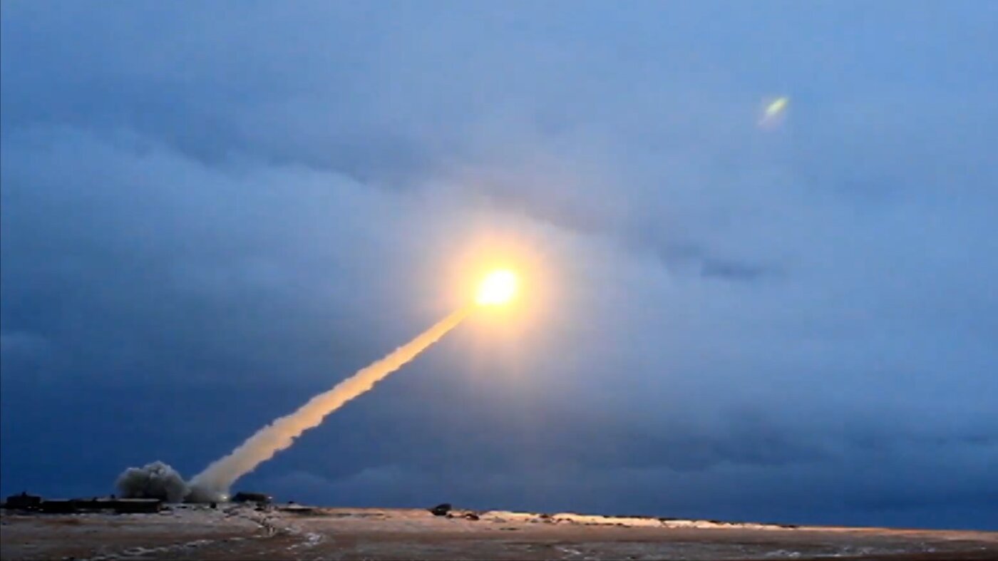
Here’s how Russia’s nuclear-powered ‘Skyfall’ missile works : NPR

Loading…
Sometime on Oct. 21 of last year, high above the Arctic Circle, a lone missile shot skyward from a Russian island.
The missile flew northeast and then banked and began flying in loops for hours over the barren, frozen landscape.
According to Russian and Western sources, the new weapon, known in Russian as Burevestnik and by NATO as Skyfall, was powered by a small nuclear reactor. Few other details were forthcoming.
Now, two MIT researchers have published an analysis that sheds fresh light on how the nuclear-powered missile actually worked. If they are correct, the October flight test marks the first time a nuclear-powered aircraft has ever flown. It would also suggest the opening of an extraordinarily dangerous new chapter in the 21st century’s simmering arms race.
“This is something that is possible, but wildly expensive and very dangerous,” said Jake Hecla, a professor at the Massachusetts Institute of Technology with a dual appointment in both aerospace and nuclear science and engineering, who led the new analysis along with co-author R. Scott Kemp.
Their modeling shows a reactor design that spews radiation as it flies, putting anyone living or working near the test site for the missile at “enormous risk, potentially.”
The dream of nuclear flight
Since the 1950s, both the U.S. and the then-Soviet Union contemplated building nuclear-powered aircraft. Such weapons had the potential to give both sides an advantage in the Cold War because they would have nearly unlimited range. That could allow them to loiter near a target awaiting an attack order almost indefinitely, or they could attack from an unpredictable direction, making it harder to defend against.
In 1955, the U.S. Air Force put a small nuclear reactor inside a Convair B-36 strategic bomber to test whether it would expose the crew to excessive amounts of radiation in flight. The reactor was never hooked up to the plane’s engines, but it did show that a nuclear reactor could fly. In 1961, the Soviet Union conducted similar experiments aboard a modified Tupolev TU-95 bomber.
Safety concerns left those concepts grounded, but the U.S. also worked on a series of nuclear reactors to power missiles. Known collectively as Project Pluto, the idea was to build a supersonic low-altitude cruise missile that could deliver a nuclear weapon to any point on Earth. The tests culminated in 1964, with the ground test of a reactor mounted on a railroad car in Nevada that could run for five minutes, producing 513 megawatts — equivalent to more than 35,000 pounds of thrust.
When news of the new Russian cruise missile first emerged, many onlookers assumed it would be a variant of the Project Pluto engine, but Hecla was skeptical. Project Pluto’s design, known as a ramjet, required air to move through it very quickly and could only operate at supersonic speeds.
“There are a number of reasons we have to suspect that a nuclear ramjet is infeasible for Burevestnik,” he said. In particular, the shape of the weapon looks much like a conventional subsonic cruise missile.
“You can see very obviously that it is a subsonic system, and ramjets are not very efficient at subsonic speeds,” he said.
A new kind of reactor
To try and figure out how the weapon was powered, Hecla first used a handful of videos posted by Russian media to determine its dimensions. He identified objects of known size in the factory where the videos were filmed — things like a utility desk or a fire extinguisher. Through many hours of repeated measurements, he was eventually able to build a three-dimensional model of the missile.
Loading…
Based on the measurements, he concluded that Burevestnik is larger than even the largest Russian cruise missiles, but it is by no means enormous. Aerodynamic modeling showed it would need to travel around Mach .75 or about 575 miles per hour to stay airborne. That speed is similar to a commercial aircraft, like the Airbus A320.
Hecla now knew roughly how big the reactor could be and how much thrust it needed to produce to make Burevestnik fly. Based on that data, and his knowledge of nuclear engineering, he was then able to model the type of reactor that might be powering the missile.
His conclusion: “It’s almost certain that the system uses a direct-cycle air-breathing nuclear propulsion system, most likely driving a turbojet,” he told NPR.
A direct-cycle system means that the reactor runs by pushing air from the atmosphere directly through the nuclear fuel. A compressor forces the air through tiny straw-like channels in the reactor core, where nuclear reactions cause the air to heat and expand out the back of the engine. Such a system is radically different from most nuclear reactors, which use an “indirect” closed loop. Those sealed systems are filled with water or another coolant and transfer heat out of the reactor while limiting radiation exposure.
Hecla said he can’t completely rule out that some sort of indirect loop is used in the missile, but given the complexity and extra weight involved with building such an indirect system, he finds it far more likely that Burevestnik is heating air by sucking it right through the reactor core.
Loading…
And that’s a big problem. “The direct cycle is very likely to result in a large quantity of radioactive material in the exhaust,” Hecla said. Air itself is irradiated as it passes through the engine, and fission decay products from the nuclear fuel also diffuse into the straw-like cavities and are shot out the back.
Hecla said his calculations show that a direct-cycle system would produce large quantities of radioactive isotopes of argon, krypton and carbon. He admits the reactor could release still more radioactivity if the core starts to corrode during hours of flight.
“Heated, compressed atmospheric air is very good at eroding engine components,” Hecla noted. There’s no reason to think this new nuclear reactor would be different.
“A terrible idea”
If Hecla is correct, then Burevestnik is the first aircraft ever built and flown using nuclear power. It’s also incredibly problematic, said Jeffrey Lewis, a scholar at Middlebury College who specializes in studying rockets and missiles and was not affiliated with the MIT study.
“This thing is an environmental nightmare,” Lewis said. In addition, the reactor poses a huge risk to members of the military who might be required to handle it. “Just the question of how you safely load one of these things is, I think, really pretty challenging,” he said.
In 2019, an accident off the Russian coast killed several Russian nuclear personnel. Shortly thereafter, a spike in radioactivity was detected nearby. It’s now widely believed the accident was the result of a Russian team attempting to recover a prototype Burevestnik reactor. Hecla said it’s possible that the reactor restarted as it was being hauled from the bottom of the sea, sparking an explosion.
Given all the problems, both real and potential, associated with Burevestnik, Hecla questions why the Russians developed it at all. He notes that although its range is likely significantly longer than that of a conventional cruise missile, that doesn’t mean it’s particularly hard to intercept.
“It’s not a game-changing idea by any stretch of the imagination,” he said. “We are able to routinely shoot down cruise missiles today, and there is no reason to think this will be particularly more difficult to do.”
Moreover, Russia has said that Burevestnik will only be used with a nuclear weapon as its warhead. A conventional warhead would likely be heavier, Lewis noted, and the reactor would still end up spreading lethal radiation over a significant area where the missile strikes. Given all that, “I can’t see the Russians wasting one to deliver a few hundred pounds of explosives,” he said.
Put it all together, and the weapon appears to be “kind of useless,” Lewis said.
Hecla suspects that Burevestnik’s development may be advancing for one of two reasons. First, he said, it’s possible that somebody within Russia’s nuclear industry has simply caught President Vladimir Putin’s ear and convinced him to invest in the program. Second, he speculates, it might be possible that the reactor in Burevestnik is just a stepping stone to developing nuclear-powered surveillance drones or space-based nuclear systems that could be useful for other missions.
Lewis agrees that the nuclear-powered missile probably isn’t very useful as a weapon. But Hecla’s paper at least shows it is technically feasible that the Russians have developed it: “It might be a bad idea, it’s almost certainly a terrible idea,” he said. “But it’s not an impossible idea.”
Tech
12 Reasons to Wait for the iPhone 18 Pro


We’re only three months out from the launch of Apple’s premium next-generation smartphone lineup, and while we’re not expecting a sea change in terms of functionality, there are still several enhancements rumored to be coming to the iPhone 18 Pro and iPhone 18 Pro Max.
One thing worth noting is that Apple is reportedly planning a major change to its iPhone release cycle this year, adopting a two-phase rollout starting with the iPhone 18 series. That means the iPhone 18 Pro, iPhone 18 Pro Max, and the long-rumored foldable iPhone (“iPhone Ultra”) will be released in September 2026, followed by the iPhone 18, iPhone Air 2, and iPhone 18e in spring 2027.
Overall Design
iPhone 17 Pro Style
Rumors suggest the iPhone 18 Pro lineup will largely retain the same design as the iPhone 17 Pro models. Most rumors suggest the rear camera system will look identical to the current generation, featuring a raised “plateau” with three lenses arranged in a triangle – although recent dummies indicate a possible thickening of the plateau and the protrusion of individual lenses. Display sizes are also expected to remain unchanged, with the iPhone 18 Pro and iPhone 18 Pro Max continuing to use 6.3-inch and 6.9-inch panels, respectively (the same dimensions introduced with the iPhone 16 Pro series). iPhone 18 Pro models could drop the current two-tone look of the rear casing found on the iPhone 17 Pro in favor of a more seamless aesthetic, while Apple has apparently updated the back-glass “replacement process” to minimize the color difference between the Ceramic Shield 2 glass and the aluminum frame, resulting in a more unified appearance.
Next-Level Battery Life
Thicker Chassis
The iPhone 18 Pro Max will feature a bigger battery for continued best-in-class battery life, claims a Chinese leaker. The Weibo user known as “Digital Chat Station” said that the iPhone 18 Pro Max will have a battery capacity of 5,100 to 5,200 mAh. (The iPhone 17 Pro Max has the biggest iPhone battery to date at 5,088 mAh. Apple says it has a battery life of up to 39 hours.) According to another rumor, the body of the iPhone 18 Pro Max will be slightly thicker than the iPhone 17 Pro Max, raising the device’s weight to around 243 grams. That would make the iPhone 18 Pro Max approximately 3 grams more than the iPhone 14 Pro Max, which is currently the heaviest model Apple has produced. A larger battery is the most likely cause.
Smaller Dynamic Island
Under-Screen Face ID?
Rumors continue to circulate about whether the iPhone 18 Pro models will introduce under-display Face ID, but reports remain divided on when the technology will actually arrive. The feature would move the TrueDepth camera system beneath the display, eliminating the need for the current Dynamic Island cutout.
According to Wayne Ma of The Information, Apple is targeting a design without a Dynamic Island, replacing it with a single pinhole camera in the upper-left corner of the screen. However, other sources dispute that claim. Display analyst Ross Young believes under-display Face ID is possible for the iPhone 18 Pro, but says a smaller Dynamic Island will still be present. Bloomberg’s Mark Gurman has echoed this view, reporting that the new models will feature a slimmed-down Dynamic Island rather than removing it entirely. Apple is also said to be testing new camera miniaturization technology to reduce the size of the front-facing camera currently located within the Dynamic Island.
The Weibo leaker “Ice Universe” has claimed the Dynamic Island cutout on the iPhone 18 Pro models will be approximately 35% narrower than it is on the iPhone 17 Pro models. Specifically, they said it will have a width of around 13.5mm, down from around 20.7mm.
Meanwhile, Chinese leaker Instant Digital has offered yet another version of events, saying the Dynamic Island will shrink in size, but that under-display Face ID and camera technology won’t debut this year. The latest word on the subject is that Apple is weighing two options for the iPhone 18 Pro’s Dynamic Island, and a final decision has yet to be made. One option apparently retains the existing screen mold from the iPhone 17 Pro, while the other introduces a significantly smaller “Mini Dynamic Island” enabled by moving the Face ID receiver and transmitter components beneath the display.
Upgraded Display
LTPO+
The iPhone 18 Pro models will reportedly use LTPO+ display technology, which should be more power efficient than the current LTPO technology in the iPhone 17 series. Such an upgrade could also contribute to longer battery life (see above), since LPTO+ enables finer control of OLED light emission, potentially allowing the display to optimize its operation based on environmental conditions. In other words, it will know better when to up screen brightness or reduce it, depending on surrounding light sources. The panels are reportedly being supplied by Samsung Display and LG Display.
A20 Pro Chip
2nm Process
The iPhone 18 Pro models will use Apple’s A20 chip, based on TSMC’s 2nm process for power and efficiency improvements. A move to 2nm fabrication increases transistor density, which will enable higher performance. The A20 series is expected to deliver roughly a 15 percent speed gain and about 30 percent better efficiency compared with the A19 series used in Apple’s iPhone 17 models.
Apple’s A20 chip will be packaged with TSMC’s Wafer-Level Multi-Chip Module (WMCM) technology, suggesting at least some A20 chips will have RAM integrated directly onto the same wafer as the CPU, GPU, and Neural Engine, rather than sitting adjacent to the chip and connected via a silicon interposer. This could contribute to faster performance for both overall tasks and Apple Intelligence, and longer battery life from improved power efficiency.
C2 Modem
Replacing Qualcomm
Apple plans to include its next-generation C2 modem in the iPhone 18 Pro models, according to supply chain analyst Jeff Pu. The chip will succeed the C1 modem, which debuted in the lower-cost iPhone 16e as Apple’s first in-house cellular modem, and the C1X modem chip in the iPhone Air, which Apple says is up to 2× faster than the C1. The C2 is expected to bring faster speeds, improved power efficiency, and support for mmWave 5G in the United States – a feature missing from the C1 and C1X.
Apple’s modem roadmap is part of a long-term strategy to reduce reliance on Qualcomm, which currently supplies 5G modems for the rest of the iPhone lineup. The company has been working on developing its own cellular chips for years, aiming for deeper integration and greater control over power management and performance.
New Camera Sensor
Samsung-Made
Samsung is working on a new three-layer stacked image sensor, reportedly intended for the iPhone 18. The sensor, referred to as PD-TR-Logic, integrates three layers of circuitry, which would improve camera responsiveness, reduce noise, and increase dynamic range. The leak comes from a source known as “Jukanlosreve,” who claims the sensor is being developed specifically for Apple’s 2026 iPhone lineup. Sony has long been Apple’s sole image sensor supplier, so Samsung’s entry would be a big shift in the iPhone’s camera supply chain.
Variable Aperture
DSLR-Style
Apple intends to equip this year’s iPhone 18 Pro models with a variable aperture lens, according to reports. Weibo-based leaker Digital Chat Station claims the main rear camera – what Apple calls the 48-megapixel Fusion camera – on both iPhone 18 Pro models will offer variable aperture, which would be a first for the iPhone. A variable-aperture system physically adjusts the lens opening, letting more light in for low-light shots or narrowing the opening for brighter scenes and deeper depth of field.
The main cameras on the iPhone 15 Pro, 16 Pro, and 17 Pro all use a fixed ƒ/1.78 aperture, where the lens is permanently set to its widest setting. With a variable lens, the iPhone 18 Pro would allow users to manually shift the aperture, similar to on a DSLR camera. This would mean more control over depth of field, enabling sharper focus on subjects or smoother background blur. Industry analyst Ming-Chi Kuo said in November 2024 that Apple’s iPhone 18 Pro models will get the feature.
5G Satellite Internet
Non-Terrestrial Data
According to a report by The Information, Apple plans to add support for 5G networks that operate via satellites rather than Earth-based towers as early as next year. This advancement would allow future iPhones to gain full internet connectivity through satellite, not just limited emergency features.
If Apple meets the 2026 target, the first devices to feature 5G satellite internet would likely be the iPhone 18 Pro, iPhone 18 Pro Max, and the long-rumored foldable iPhone. Apple partners with Globalstar for its iPhone satellite features, but there is currently no service that delivers full 5G satellite internet directly to a smartphone. That said, Amazon and Globalstar announced in April a definitive merger agreement under which Amazon will acquire the satellite operator. Amazon’s Leo satellite network will power existing iPhone features – with scope for additional feature support as part of a forthcoming infrastructure upgrade.
Simplified Camera Control
New Design
Apple is reportedly working to simplify the Camera Control button’s design on iPhone 18 models in order to reduce costs. The current Camera Control button on iPhone 17 models uses both capacitive and pressure sensors beneath a sapphire crystal surface. The capacitive layer detects touch gestures, while the force sensor recognizes different pressure levels for taps, presses, and swipes.
However, according to the Weibo-based account Instant Digital, Apple will remove the capacitive sensing layer and retain only pressure sensing recognition in the second iteration to achieve all Camera Control functions on the iPhone 18. The simplified version is not about reducing functionality in the button, but about saving money. The current solution is said to be very expensive for Apple and is generating costly after-sales repairs.
We don’t expect Camera Control to go away anytime soon – Apple apparently sees it as a key feature, so much so that it has reportedly made deliberate engineering compromises to ensure that the first foldable iPhone features the button.
New Colors
Three in Testing
In February 2026, Bloomberg’s Mark Gurman reported that Apple is testing a deep red finish for the iPhone 18 Pro and iPhone 18 Pro Max. Rumors of purple and brown finishes have also circulated, but Gurman believes those are just variants of the same red idea. Since then, we’ve seen aligned rumors that the devices will come in light blue, dark cherry, dark gray, and silver.
The iPhone 14 Pro and iPhone 14 Pro Max were previously available in Deep Purple, and Apple has never released an iPhone in a genuinely brown color. According to a Chinese leaker, Apple’s iPhone 18 Pro models won’t come in black this year. If the rumor is true, it will be the second consecutive year Apple has ditched what was arguably its most classic color option for the Pro lineup.
iOS 27
Smarter Siri
The iPhone 18 Pro will ship with iOS 27, which brings the biggest Siri shake-up in the assistant’s history. Apple introduced Siri AI at WWDC in June – a rebuilt, more conversational version of Siri with onscreen awareness, personal context understanding, and broad world knowledge that lets it pull up-to-date answers from the web. It also gains its own standalone app for revisiting past conversations, an expanded Visual Intelligence mode, and writing tools that work across email, messages, and documents. Like the iPhone 17 Pro, the iPhone 18 Pro is expected to carry 12GB of RAM, so it should run the full range of Siri AI and Apple Intelligence features.
Tech
Strait of Hormuz reopening may take weeks


Stringer | Reuters
It will take weeks to clear the backlog of ships in the Strait of Hormuz, industry executives and shipping experts have warned, as the critical waterway is set to reopen.
Oil prices initially dipped below $80 per barrel on news that the U.S. and Iran had agreed on a deal to end their war, as traders looked to the supply of oil, LNG and other goods being restored after nearly four months of war caused a maritime traffic jam of ships unable or unwilling to transit the Strait.
U.S. President Donald Trump and Iranian President Masoud Pezeshkian signed the memorandum of understanding on Wednesday night. It calls for the full reopening of the Strait of Hormuz without tolls by Iran for at least 60 days.
But restoring enough physical supply to the market to keep prices at a stable sub-$80 level could take weeks, and in some cases months, market watchers have told CNBC.
Operators, port authorities and energy companies across the Gulf remain in a holding pattern, with key logistical and security questions still unresolved.
“The most likely scenario is a phased restart, with some form of traffic-management mechanism involving Iran and Oman,” Adam Sharpe, vice president of editorial at Lloyd’s List Intelligence, told CNBC.
“But the unresolved questions are significant: whether vessels need prior permission, whether Iran will impose service charges, whether foreign naval escorts are accepted, and whether mines or other residual risks require a clearance process.”
Why reopening the Strait of Hormuz is complicated
Even after a political agreement to reopen the Strait, industry participants say restarting traffic will be complex and staged.
“There is no precedent for restarting Hormuz after a disruption of this nature,” Sharpe said. “A cautious working assumption would be a gradual ramp-up rather than an immediate return to 100-plus daily transits.”
Before the war, Lloyd’s List Intelligence data showed weekly Strait of Hormuz cargo-vessel transits of roughly 650 to 770 vessels, equivalent to around 90 to 110 transits per day across both directions.
Economic intelligence provider QuantCube Technology told CNBC its shipping data has yet to show a meaningful increase in oil export departures from Saudi Arabia, the UAE or Iraq.
In Saudi Arabia’s Dammam region, which includes the Ras Tanura export complex, vessels have been loaded and sent offshore to wait, according to Alan Lemangnen, senior economist at QuantCube.
“Since June 8, tankers departing Dammam have spent significantly longer waiting at anchor before departure,” he told CNBC. “This suggests that a queue of vessels may have formed offshore rather than at port facilities.”
Most of the UAE’s successful crude flows through Hormuz involved “going dark,” in which ships turn off GPS systems to avoid detection. Kpler said dark shipping activity is likely to continue until Washington and Tehran reach a clear understanding on freedom of navigation.
How big is the Hormuz shipping backlog?
Even if energy supply flows recover quickly, supply-chain disruption could continue. In a note published Monday, Kpler estimated 118 tankers were stranded in the Persian Gulf.
Kpler analysts estimate the backlog could take 10 to 15 days to clear, but warned that this would not amount to a full recovery. The initial boost, they said in the note, would be “purely mechanical,” delivering “an early spike in transits without lifting underlying throughput.”
If hundreds of vessels are waiting to transit the Strait, prioritization becomes critical. Industry experts expect oil tankers and LNG carriers to receive priority access because of their importance to global markets, potentially leaving container shipments and other cargo facing longer delays.
“Prioritization may not be purely commercial,” Sharpe said. “Authorities may also consider vessel location, direction of travel, flag, ownership, perceived political risk, cargo type, safety condition, and whether a vessel has already submitted the required transit information.”
“The biggest uncertainty is whether this will be handled transparently or through ad hoc operational decisions,” he added.
Traders and manufacturers in the region are already reporting higher raw-material prices and shipment delays, underscoring how quickly disruptions in Hormuz ripple through regional economies.
Insurers and security checks matter
Before traffic can return to normal, naval forces need to certify safe transit corridors, which is expected to take at least several days. War-risk insurers must then reinstate coverage, without which vessels won’t move. Authorities in Oman, the UAE and Iran will also need to coordinate shipping lanes, convoy systems or transit windows, while ships and crews positioned for diversion or delay must be reactivated, refuelled and scheduled.
“Underwriters will want evidence of a stable and predictable operating environment: consistent safe transits, no interference, clarity on mine risk, and no renewed escalation,” Sharpe said. Pricing, he added, is likely to remain highly sensitive to vessel flag, ownership, Israeli or U.S. nexus, trading history and cargo.
“Underwriters will want evidence of a stable and predictable operating environment: consistent safe transits, no interference, clarity on mine risk, and no renewed escalation. Current pricing is likely to remain highly sensitive to flag, ownership, Israeli or US nexus, trading history and cargo. A durable reduction in additional premiums will depend on sustained historic transit volumes and confidence that the reopening is not reversible.”
Adam Sharpe
“A durable reduction in additional premiums will depend on sustained historic transit volumes and confidence that the reopening is not reversible,” he said.
There is also a security component, with Iran and the U.S. needing to coordinate on mine clearance, another process that could slow things down.
“Until there is full certainty that there are no mines, the process will be slow and would take a few weeks since only a small passage is then available safely,” Nikos Petrakakos, managing director at maritime investment manager Tufton, told CNBC over email. “Once clarity with mines is secured, then it could be less than a week. But I feel many will be cautious at first.”
Sharpe pointed to the Red Sea as a cautionary comparison, saying many operators remained reluctant to return even after de-escalatory signals that the Houthis had stopped firing on ships, without sustained proof of safety.
When could shipping through Hormuz normalize?
Kpler said most Middle Eastern production returns in weeks rather than months, but when that production can actually be exported is another question.
Much will depend on how quickly authorities, insurers and shipping companies can coordinate the reopening and restart the movement of goods. The initial 10- to 15-day clearing of the tanker backlog may create a visible spike in traffic, but a return to normal throughput could take longer if insurance premiums remain elevated, naval checks are slow or operators remain cautious.
What reopening means for oil prices
Goldman Sachs reduced its oil price forecast following Trump’s announcement of a deal, lowering its Brent forecast to $80 per barrel for the fourth quarter of 2026, from $90 previously, and to $75 for the 2027 average. But in the near term, prices could remain under pressure.
In a note published June 16, Goldman said “supply recovery might be stronger” and estimated that Gulf flows had already risen to 11 million barrels per day, with increases in both Hormuz flows and redirections.
Tech
Tropical Storm Arthur lashes Gulf Coast, unleashing life-threatening flood threat

9:19 PM ET 2 Min Ago
Rainfall associated with Tropical Storm Arthur expected to increase as conditions worsen overnight
Tropical Storm Arthur continues to move along the Gulf Coast with maximum sustained winds of 40 mph.
During the overnight hours, rainfall caused by Arthur is expected to increase, with the worst impacts and life-threatening flooding still to come.
Many areas across the Gulf Coast, including Louisiana and Texas, are already experiencing flooding that is expected to worsen overnight.
Over the coming days, Arthur is forecast to track across the Southeast before approaching the Carolinas by Friday evening.
As the storm moves offshore, it is expected to pass over the warmer waters of the Gulf Stream.
During this period, a new area of low pressure could develop, bringing gusty winds and heavy downpours to coastal communities.
7:34 PM ET 1 HR AgoBreaking News
Pinned
8:00 p.m. ET advisory: Arthur’s center re-forms near Galveston as winds ease slightly to 40 mph
The National Hurricane Center’s 8:00 p.m. ET (7:00 p.m. CDT) advisory reveals that Tropical Storm Arthur’s disorganized center has erratically re-formed further northeastward, placing it just 10 miles northwest of Galveston, Texas.
Moving northeast at 8 mph with a minimum central pressure of 1000 mb, the storm has seen its maximum sustained winds ease slightly to 40 mph.
Because the system’s core has shifted, officials have officially discontinued the Tropical Storm Warning west of High Island, Texas, though the warning remains in effect from High Island eastward to Morgan City, Louisiana.
Despite the minor drop in wind intensity, Arthur’s sprawling wind field still stretches outward up to 175 miles—primarily to the southeast of the center over open water—where an offshore oil rig recently clocked sustained winds of 38 mph.
While the official track indicates Arthur should grind further inland over southeastern Texas tonight before potentially dissipating by Thursday morning, the FOX Forecast Center stresses that the catastrophic, life-threatening flash flood threat remains entirely unchanged.
The storm’s slight structural decay over land does not diminish its massive tropical moisture shield, which will continue to act as an atmospheric pump across the Deep South overnight.
Relentless training downpours are still projected to dump widespread totals of 5 to 10 inches across portions of the Gulf Coast and the wider Southeastern United States.
7:30 PM ET 1 HR Ago
Numerous Texas beaches damaged as Tropical Storm Arthur moves along the Gulf Coast
Tropical Storm Arthur is currently moving east along the Gulf Coast, impacting several states, including Texas, Louisiana and Alabama.
In Texas, officials have reported significant beach erosion and damage, creating hazardous conditions for beachgoers. Dangerous rip currents are also affecting the coast.
Storm surge levels have reached up to 3 feet in some areas and are expected to increase overnight.
Rising water levels will likely worsen beach conditions and contribute to additional flash flooding across the region.
7:30 PM ET 1 HR Ago
Awaiting the 8:00 p.m. ET advisory for critical checks on Tropical Storm Arthur
The FOX Forecast Center is keeping a close watch on the radar as we approach the National Hurricane Center’s 8:00 p.m. ET (7:00 p.m. CT) intermediate advisory on Tropical Storm Arthur.
Following this afternoon’s slow crawl further inland over southeastern Texas, this evening data drop will offer a vital status check on whether Arthur’s 45 mph sustained winds have begun to spin down over land.
Meteorologists will be pinpointing the exact position of Arthur’s messy center of circulation to see if it is maintaining its north-northeastward trajectory toward southwestern Louisiana.
6:27 PM ET 2 HRS Ago
Satellite video shows Tropical Storm Arthur moving along Texas coast
Satellite video shows Tropical Storm Arthur swirling and moving along the Texas coast.
5:37 PM ET 3 HRS Ago
Live tracking: Watch Tropical Storm Arthur in real time as it slams the South
As Tropical Storm Arthur continues to dump rain across portions of the South, here’s how you can track the storm in real time.
Click the link below for the live radar, forecast cone, flood threat, spaghetti models and warnings.
5:23 PM ET 3 HRS Ago
Analysis: Did Tropical Storm Arthur ever actually go out to sea?
As Tropical Storm Arthur grinds its way over Texas, armchair meteorologists and coastal residents tracking the storm online have noticed something bizarre. At one checkpoint, the National Hurricane Center’s official coordinates place Arthur’s center over the open waters of the Gulf of America.
Just a few hours later, the coordinates map out firmly over solid Texas dirt. This has triggered a wave of confusion: did Arthur officially make landfall in Texas? And was it ever really out over the open Gulf waters in the first place?
To answer the second question first: no, Arthur was never truly out over the “open” waters of the Gulf of America after it officially earned its name. The storm spent its brief lifecycle practically touching the beach.
When the NHC plots the center of a tropical system, they are pinpointing a single mathematical dot representing the low-level center of circulation.
Because the Texas coastline curves dramatically and is heavily fragmented by barrier islands, bays, and protruding marshes, a storm tracking in a straight line northeast will naturally map over water one hour and over a peninsula the next.
This geographical zig-zag is exactly why we haven’t seen—and likely won’t see—a formal Texas landfall declaration from the NHC.
For a system to officially make landfall, its center of circulation must decisively cross from the ocean onto a major landmass. Arthur isn’t doing that; it is essentially “scraping” the shoreline.
The center is straddling the literal surf, occasionally cutting across small barrier islands or inland bays like Matagorda Bay before clipping the next piece of coastline.
While it might look like a technical error on tracking maps, it is just the reality of a messy, lopsided storm hugging a jagged coast.
5:09 PM ET 4 HRS Ago
“This happened within 30 minutes:” Mississippi resident loses animals, workshop to sudden deluge
The devastating human and emotional toll of Tropical Storm Arthur’s relentless moisture shield became painfully clear in southern Mississippi, where a local resident lost her home, workshop, and family animals to a sudden, catastrophic flash flood.
Heartbreaking video footage captured by Kristina Malott in Picayune, Mississippi, showcases a front yard completely swallowed by rising water, with household items floating aimlessly and plants completely submerged.
Wading through the deep deluge, Malott can be heard saying, “That’s up to my shin,” as she navigates the property. The footage takes a tragic turn as she opens the door to her heavily inundated backyard shed, revealing that the water rose too fast for her farm animals to escape.
No words. This happened within 30 minutes. Whole downtown was flooded. My chickens drowned. Workshop total loss.
– Kristina Malott
Malott noted that the rapid high water also severely damaged her house, pointing out that while her yard has experienced minor flooding in the past due to overwhelmed street drains, it has never experienced anything close to this scale.
The localized disaster perfectly illustrates how dangerous Arthur’s outer rainbands are, even hundreds of miles away from the storm’s actual center.
According to the FOX Forecast Center, the Picayune area has already been battered by a staggering 5 to 8 inches of rain over the last 48 hours.
With the ground entirely saturated and more tropical downpours on the way, the National Weather Service has extended a Flood Watch for Picayune and surrounding Pearl River County through Friday.
4:58 PM ET 4 HRS Ago
5:00 p.m. ET advisory: Tropical Storm Arthur slows down as it crawls further inland over Texas
The National Hurricane Center’s 5:00 p.m. ET (4:00 p.m. CT) advisory confirms that Tropical Storm Arthur is holding onto 45 mph maximum sustained winds but has slowed its forward movement to a 7 mph crawl.
The center of the structurally disorganized storm is currently located about 20 miles north-northwest of Matagorda, Texas, and 195 miles west-southwest of Lake Charles, Louisiana, with a minimum central pressure of 1001 mb.
While the official track keeps the core grinding north-northeastward farther inland over southeastern Texas tonight before potentially dissipating by Thursday morning, a Tropical Storm Warning remains firmly in effect from Sargent, Texas, to Morgan City, Louisiana.
The storm’s expansive wind field continues to whip the region, stretching tropical-storm-force winds outward up to 175 miles and prompting a recent offshore buoy report of a 52 mph gust east of Galveston.
Despite the expectation that Arthur will rapidly spin down into a remnant low over land, the primary threat remains intensifying, life-threatening flash flooding across the Southeastern United States.
Because the storm has slowed to a crawl, it will continue to act as an atmospheric pump, relentlessly dragging rich Gulf moisture inland long after the center breaks apart.
Forecasters warn that a widespread 5 to 10 inches of rain—with catastrophic, localized totals threatening to eclipse 20 inches—will slam portions of Texas, Louisiana, Mississippi, and Alabama through the end of the week.
With dangerous 2-to-4-foot storm surge already causing inundation along the immediate coast and intense inland rainfall trapping drivers, emergency management officials reiterate that residents should stay off the roads, remain sheltered in place, and keep multiple methods active for receiving wireless weather warnings throughout the night.
4:39 PM ET 4 HRS Ago
What to watch for in Tropical Storm Arthur’s major 5:00 p.m. ET advisory
The FOX Forecast Center is gearing up for the National Hurricane Center’s 5:00 p.m. ET (4:00 p.m. CT) advisory package on Tropical Storm Arthur.
Unlike the intermediate updates we’ve tracked throughout the afternoon, this late-afternoon release is a full advisory data drop, meaning meteorologists will receive a completely updated forecast track, an official look at whether Arthur’s 45 mph winds have fluctuated, and fresh guidance on the storm’s exact trajectory toward the Louisiana border.
4:01 PM ET 5 HRS Ago
Turn around, don’t drown: Water rises up to taillights in scary Texas flood video
This harrowing video out of The Woodlands, Texas, serves as a stark reminder of why emergency officials constantly preach the phrase, “Turn around, don’t drown.”
Torrential downpours completely transformed a local roadway into a treacherous swamp on Tuesday, trapping a driver as water quickly rose just beneath their vehicle’s taillights.
Forced to abandon the car, the driver had to take refuge on a tiny patch of higher ground among nearby trees while waiting for rescue. The frightening footage underscores how rapidly hidden dips in the road can become death traps during intense tropical rain events.
3:30 PM ET 5 HRS Ago
Video captures torrential rain turning backyard into a river in Magnolia, Texas
New video out of Magnolia, Texas, highlights the severe flash flood threat unfolding north of Houston as Tropical Storm Arthur lashes the region.
Persistent, torrential downpours have completely overwhelmed local drainage systems, turning neighborhood streets into rushing rivers and straddling roadways with several feet of high water.
3:19 PM ET 6 HRS Ago
Analysis: Has Tropical Storm Arthur already made landfall? Why an official call is complicated
With the center of Tropical Storm Arthur tracking just inches from the sand, many coastal residents are wondering: has the storm already technically made landfall?
Looking at the exact coordinates from the National Hurricane Center’s last advisory, the exact center of circulation is already over land and has practically bounced right across the barrier islands and mudflats of the middle Texas coast over the last few hours.
Yet, the (NHC) has not issued an official, formal “landfall declaration.”
This lack of an official announcement comes down to a strict meteorological technicality. By definition, the NHC only declares an official landfall when the precise, low-level center of a storm crosses fully over a solid landmass.
Because Arthur is an incredibly messy, lopsided, and highly “sheared” system, its center is fluid and elongated rather than a tight, well-defined eye. As it tracks northeast, it is moving almost perfectly parallel to the shape of the upper Texas shoreline.
The center is essentially scraping the surf—wobbling slightly onto the beach one minute and slipping back over a coastal bay the next.
Because it is straddling the literal coastline rather than definitively marching inland over Texas, forecasters at the NHC may choose to bypass a formal landfall alert entirely for this leg of the trip.
Instead, they may treat this stretch as a continuous “scraping” of the coast until the center makes its final, decisive push inland over southwestern Louisiana tonight.
The FOX Forecast Center reminds everyone that whether the center is 5 miles offshore or 5 miles inland changes nothing about the reality on the ground: the powerful wind gusts, 2-to-4-foot storm surge, and life-threatening flash flooding are already actively hammering the region.
2:49 PM ET 6 HRS Ago
Storm surge spills over Galveston Bay with over 2 feet of inundation observed
The rapid onset of Tropical Storm Arthur is making a visible impact on local waterways this afternoon, with gauge observations confirming that storm surge has officially surpassed 2 feet of inundation across parts of the Galveston Bay area.
People in flood-prone areas near the bay should monitor rising water levels closely and avoid driving through submerged roads, as saltwater can quickly stall vehicles and mask deeper washouts.
2:44 PM ET 6 HRS Ago
Tornado spotted in southern Alabama as tropical downpours inundate the state
The National Weather Service has issued a Tornado Warning for Dale County in southeastern Alabama.
Radar data has officially confirmed a tornado is on the ground and actively moving near the town of Ozark.
This is a dangerous situation, and anyone in the path of this rotating storm needs to act immediately.
If you are located in Ozark or the surrounding Dale County area, drop what you are doing and seek safe shelter right now. Move to the lowest floor of a sturdy building, placing yourself in an interior room like a closet, hallway, or bathroom away from all windows.
Avoid mobile homes or vehicles at all costs, as flying debris will be highly lethal to anyone caught unsheltered in this zone.
2:32 PM ET 6 HRS Ago
Analysis: Where Arthur’s worst downpours will focus tonight as the storm moves inland
While the center of Tropical Storm Arthur is busy scraping the upper Texas coast, the atmospheric steering currents are already mapping out where the absolute worst of the deluge will set up tonight.
Because Arthur is structural mess with its heaviest elements skewed far to the east, the FOX Forecast Center is tracking a dangerous axis of heavy rain that is forecast to solidify well away from the center this evening.
This maximum rain zone is expected to form just north of New Orleans, stretching across southern Mississippi and cutting directly into western and central Alabama.
This particular setup is highly concerning because a massive corridor of rich, deep Gulf moisture is pooling along a stationary coastal front.
As Arthur pushes inland later today, it will act like a pump, relentlessly driving training tropical thunderstorms—storms that roll over the exact same neighborhoods like railroad cars—along this specific line.
With widespread rain totals of 5 to 10 inches expected across this target zone and localized amounts easily capable of eclipsing a foot, communities in southern Mississippi and central Alabama must prepare for an intensifying flash flood threat that will last straight through the overnight hours.
1:56 PM ET 7 HRS Ago
Arthur maintains 45 mph strength in 2:00 p.m. ET advisory, moving toward Louisiana
The National Hurricane Center has released its 2:00 p.m. ET (1:00 p.m. CT) intermediate advisory on Tropical Storm Arthur, confirming the system is maintaining its 45 mph strength as it edges closer to landfall.
The center of the storm is currently located about 55 miles northeast of Port O’Connor, Texas, tracking steadily northeastward at 9 mph.
While there are no formal changes to the current slate of watches and warnings, a Tropical Storm Warning remains in full effect from Sargent, Texas, all the way to Morgan City, Louisiana, with tropical-storm-force conditions actively spreading across the region.
The latest data shows Arthur’s central pressure has deepened slightly to 1000 mb, and its expansive wind field continues to stretch outward up to 175 miles from the center.
Offshore, a NOAA buoy east of Galveston recently clocked sustained winds of 47 mph and a hefty gust of 54 mph. The official forecast track keeps Arthur scraping along southeastern Texas before moving fully inland over southwestern Louisiana tonight.
Forecasters warn that once the center moves further inland, Arthur will weaken rapidly and likely dissipate by early Thursday—but the primary hazard remains a massive punch of tropical moisture capable of causing life-threatening flash flooding across the southeastern United States today.
1:43 PM ET 7 HRS Ago
What to look for in the upcoming 2:00 p.m. ET intermediate advisory on Arthur
The FOX Forecast Center is keeping a close eye on the clock as we approach the National Hurricane Center’s upcoming 2:00 p.m. ET (1:00 p.m. CT) intermediate advisory.
Since Arthur was officially upgraded to a tropical storm just a few hours ago, this next data drop will provide crucial mid-day checkpoints on the storm’s exact location, current forward speed, and whether those fierce 45 mph sustained winds are continuing to fluctuate.
1:15 PM ET 8 HRS Ago
Tropical Storm Arthur nears landfall along Texas coast after intensifying to 45 mph
The final countdown is officially on for the first named storm of the season. According to a special update from the National Hurricane Center, Tropical Storm Arthur is steadily losing real estate over open water as its center tracks perilously close to the upper Texas shoreline, steering it toward an imminent final landfall.
Arthur has intensified slightly, with maximum sustained winds now up to 45 mph, and the system is beginning to pick up forward speed as it pushes northeastward at 9 mph.
Because Arthur’s center of circulation is traveling nearly parallel to the beachheads, it will continue to scrape along or briefly cross the immediate Texas coast over the next few hours.
1:01 PM ET 8 HRS Ago
Tropical Storm Arthur flexes its muscles with a 64 mph wind gust in Galveston
Tropical Storm Arthur is showcasing some serious power this afternoon as it continues to brush past the upper Texas coast.
The system has unleashed a barrage of tropical-storm-force winds across regional beaches, highlighted by a fierce, peak wind gust of 64 mph officially clocked at a monitoring station in Galveston.
12:44 PM ET 8 HRS Ago
Galveston clocks fierce 59 mph wind gust as Tropical Storm Arthur lashes the coast
The true strength of newly upgraded Tropical Storm Arthur was felt directly on land this midday when a powerful wind gust of 59 mph was officially recorded on Galveston Island.
As the core of the storm aggressively scrapes along the upper Texas beaches, its massive wind field is punching inland, downing tree limbs and causing scattered power outages across the area.
12:37 PM ET 8 HRS Ago
Tropical Storm Arthur intensifies to 45 mph; warnings extended south to Sargent, Texas
The National Hurricane Center has issued a special midday update for Tropical Storm Arthur as the system shows signs of slight intensification while hugging the upper Texas coast.
Arthur’s maximum sustained winds have ticked up to 45 mph, a modest increase from the 40 mph winds observed just hours earlier.
In response to the storm’s expanding wind field and closer track, the NHC has extended the Tropical Storm Warning southward to include Sargent, Texas.
This upgraded warning means that tropical-storm-force conditions are now imminent for the Sargent area over the next several hours.
With Arthur’s winds strengthening and its core continuing to track perilously close to the beachfronts, residents from Sargent, Texas, all the way to Morgan City, Louisiana, should prepare for worsening coastal flooding, dangerous surf, and localized power outages as the tropical storm prepares to make its final move inland.
12:06 PM ET 9 HRS Ago
Into the storm: How the Hurricane Hunters sealed the deal on naming Tropical Storm Arthur
When a messy, disorganized tropical disturbance is lurking right along the coastline, meteorologists can only learn so much from satellites sitting thousands of miles out in space.
To truly understand what is happening inside a system like Tropical Storm Arthur, you have to go straight to the source. That is where the brave men and women of the Hurricane Hunters come in.
Their data-gathering missions this morning were the ultimate “smoking gun” that allowed the National Hurricane Center to officially upgrade the system to Tropical Storm Arthur at 11:00 a.m. ET.
Flying directly into the world’s most violent weather requires specialized, incredibly robust aircraft. The U.S. government utilizes two primary types of planes to hunt storms, each serving a unique scientific purpose:
The Lockheed WC-130J Hercules: Flown by the Air Force Reserve’s 53rd Weather Reconnaissance Squadron out of Keesler Air Force Base in Mississippi, this rugged turboprop is the workhorse of low-to-mid-level storm hunting. It is built to fly directly through the eyewall of a storm at altitudes around 10,000 feet, alpha-checking the center, measuring surface winds, and dropping sensors called dropsondes directly into the tempest.
The NOAA WP-3D Orion & Gulfstream IV-SP: NOAA employs two heavily modified P-3 turboprops (affectionately named Kermit and Miss Piggy) to gather high-resolution radar and atmospheric data inside the storm core. To complement them, NOAA also flies a high-altitude Gulfstream IV jet. Operating at up to 45,000 feet, this jet maps the steering currents around a storm, providing the crucial data needed to predict exactly where a storm will travel.
It was a WC-130J crew flying right through the messy core of Potential Tropical Cyclone One this morning that officially broke the forecasting logjam. While satellites showed a highly sheared, lopsided system, the Hurricane Hunters were able to pinpoint a closed low-level center of circulation scraping the Texas beaches.
More importantly, their onboard instruments clocked powerful flight-level winds reaching up to 60 mph just above the ocean.
By beaming this real-time ground truth back to forecasters in Miami, the Hurricane Hunters provided the definitive proof that Arthur had achieved tropical storm intensity.
Without these flights, emergency managers and coastal residents would be missing the vital, precise data needed to prepare for life-threatening flash flooding and tropical-storm-force winds.
11:37 AM ET 9 HRS Ago
Could Arthur rise from the dead? Forecasters eye potential second act near North Carolina
Tropical Storm Arthur hasn’t even made its Gulf Coast landfall yet, but FOX Weather meteorologists are already keeping a close eye on a potential second act for the system later this week.
Long-range computer models suggest that after Arthur moves inland over Louisiana tonight and falls apart over the Deep South, its leftover energy and tropical moisture will get swept eastward across the Southeast.
On Friday, these remnants are expected to push off the coast of North Carolina and emerge over the warm waters of the Atlantic Ocean.
Once back over open water, there is a distinct possibility that the ghost of Arthur could try to slowly reorganize.
While the system would have to contend with unfavorable atmospheric wind shear, the combination of rich Gulf moisture and warm ocean temperatures near the Gulf Stream might give it just enough fuel to attempt a subtropical or tropical reformation off the Carolina coast.
11:16 AM ET 10 HRS Ago
When will Tropical Storm Arthur make landfall? Center continues to scrape Texas coast
Now that Tropical Storm Arthur has officially formed, the next big question is exactly when and where the center will make landfall.
Because the newly christened storm is scraping right along the middle Texas coast, its center of circulation will continue to wobble incredibly close to—and occasionally over—the immediate Texas beaches over the next few hours.
Because of this, Arthur could make landfall along the Texas coast in the next few hours before ultimately moving inland, spreading flooding rains across the South.
11:05 AM ET 10 HRS Ago
Analysis: Why the National Hurricane Center officially named Tropical Storm Arthur
For hours, meteorologists debated whether a messy cluster of thunderstorms hugging the Texas coast would ever become a named storm, but at 11:00 a.m. ET, the National Hurricane Center officially pulled the trigger on Tropical Storm Arthur.
The decision came down to a sudden burst of persistent thunderstorm activity and a mountain of fresh data proving the storm had finally checked all the structural boxes.
Satellite analysis from the Tropical Analysis and Forecast Branch (TAFB) confirmed that despite intense atmospheric wind shear tearing at the storm, it had developed enough core organization to officially be designated as a sheared tropical cyclone.
The real smoking gun, however, came from a combination of brave crews in the sky and sensors in the sea. Within the hour leading up to the advisory, automated ocean buoys and a passing ship braving the rough waters clocked legitimate tropical-storm-force winds on the eastern side of the storm.
Simultaneously, Air Force Reserve Hurricane Hunters flying directly into the system recorded powerful flight-level winds reaching up to 60 mph (52 knots) just above the ocean surface.
Combined, this wealth of real-time data proved Arthur was packing sustained surface winds of at least 40 mph (35 knots)—giving forecasters all the evidence they needed to officially cross Potential Tropical Cyclone One off the board and crown Arthur as the first named storm of the season.
10:58 AM ET 10 HRS Ago
Tropical Storm Warning extended into Texas as Tropical Storm Arthur lashes the coast
With the storm officially naming, officials have extended the Tropical Storm Warning westward to include High Island, Texas, meaning tropical storm conditions are expected from High Island all the way to Morgan City, Louisiana, within the next 12 hours.
10:56 AM ET 10 HRS Ago
The first named storm of the season is here: Tropical Storm Arthur develops in the Gulf
We have a named storm. The National Hurricane Center’s highly anticipated 11:00 a.m. ET (10:00 a.m. CT) advisory confirms that Potential Tropical Cyclone One has officially organized into Tropical Storm Arthur.
Data from the Air Force Reserve Hurricane Hunters and nearby coastal surface observations show the system’s maximum sustained winds have ticked up to 40 mph, officially crossing the tropical storm threshold.
The center of Arthur is currently located about 40 miles east-northeast of Port O’Connor, Texas, and is trekking northeast along the coast at a slightly faster 9 mph clip.
10:54 AM ET 10 HRS Ago
National Hurricane Center announces Tropical Storm Arthur has formed in the Gulf of America
The National Hurricane Center just dropped its highly anticipated 11:00 a.m. ET (10:00 a.m. CT) full advisory package for Tropical Storm Arthu.
The FOX Forecast Center is actively breaking down the fresh data, including the newly revised official forecast track, updated wind fields, and the latest coordinates from the Air Force Reserve Hurricane Hunters.
Stay tuned for updates on the forecast.
10:44 AM ET 10 HRS Ago
Hurricane Hunters find a center for PTC One, but structural hurdles remain
The Air Force Reserve Hurricane Hunters flying inside Potential Tropical Cyclone One this morning have officially located a low-level center of circulation, but the system is still a long way from becoming a organized tropical storm.
Even though a center exists, satellite and radar data show there is virtually no deep thunderstorm activity directly surrounding it. Instead, the severe wind shear continues to lop-sidedly displace all the heavy weather more than 100 miles off to the east.
Because this newly found center is still scraping right along the muddy coastline rather than emerging over the wide-open, warm waters of the Gulf of America, the system appears too structurally starved to formally earn the name Arthur for now.
10:38 AM ET 10 HRS Ago
What to expect when the 11:00 a.m. ET storm update drops from the NHC
The FOX Forecast Center is closely monitoring the clock as we approach the National Hurricane Center’s crucial 11:00 a.m. ET (10:00 a.m. CT) advisory package.
Unlike the smaller intermediate checkpoints, this full advisory is a major one that will provide a brand-new, officially revised forecast track and an updated look at the “forecast cone” as the system scrapes the Texas coast.
FOX Weather meteorologists will be dissecting fresh data to determine if the system has managed to build a closed core or if severe wind shear has continued to keep it disorganized.
10:05 AM ET 11 HRS Ago
Rough surf and churning waves lash Galveston beaches as PTC One approaches
New video out of Galveston shows increasingly violent, churning waves slamming into the Texas coastline this morning as Potential Tropical Cyclone One pushes its wind field closer to shore.
The powerful surf is already spilling over seawalls and pushing water into coastal roads, serving as a visual reminder of the dangerous storm surge and localized beach erosion expected along the upper Texas coast today.
9:49 AM ET 11 HRS Ago
Flash flood threat rises across south-central Alabama as tropical downpours expand
The threat of flash flooding is increasing across portions of south-central Alabama this morning as an influx of intense tropical moisture collides with an approaching coastal front.
The FOX Forecast Center warns that rapidly expanding showers and thunderstorms are tracking directly over communities already dealing with saturated soils.
Atmospheric conditions are primed for dramatic downpours, with tropical moisture levels climbing to near-historic levels. Fueled by this surge of unstable Gulf air, these organizing storms are capable of unleashing ferocious rain rates of up to 2.5 inches per hour.
These extreme hourly totals are expected to trigger rapid water accumulation, presenting a significant threat for sudden flash flooding into this afternoon, particularly in low-lying and urban areas.
9:43 AM ET 11 HRS Ago
New Hurricane Hunters mission underway to see if Potential Tropical Cyclone One has organized
The Air Force Reserve Hurricane Hunters are back in the sky, flying a brand-new reconnaissance mission directly into Potential Tropical Cyclone One this morning.
With the disorganized system currently hugging the Middle Texas coastline and running out of time over open water, the specialized aircrew is tasked with checking the storm’s vital signs to see if it has managed to pull itself together.
The data gathered during this flight is crucial for forecasters at the National Hurricane Center. The plane will fly directly through the broad low-pressure center to look for two specific elements: a well-defined, closed low-level circulation and sustained tropical-storm-force winds of 40 mph or greater.
If the crew finds that the center has finally stopped straddling the coast and organized a tight core, it could trigger the official upgrade to Tropical Storm Arthur.
The real-time atmospheric data from the flight will be immediately injected into global computer models to sharpen the final track and rainfall predictions before the system pushes inland over southwestern Louisiana tonight.
9:25 AM ET 11 HRS Ago
Picayune fire station surrounded by floodwaters as tropical downpours slam Mississippi
The hurricane season’s first major tropical threat is unleashing life-threatening flash flooding across multiple states as Potential Tropical Cyclone One sends relentless bands of torrential rain deep into the Gulf Coast.
The extreme nature of the deluge was put on full display in Picayune, Mississippi, where a local fire station became completely surrounded by rapidly rising high waters as the core of the heavy rainfall shifted into the state on Tuesday.
9:21 AM ET 11 HRS Ago
Flash Flood Warning issued for Houston metro area as torrential tropical rain hits
The National Weather Service has issued a Flash Flood Warning for the Houston metro area, in effect until 10:30 a.m. CT (11:30 a.m. ET).
Intense, moisture-packed rainbands from Potential Tropical Cyclone One have moved directly over the city, unleashing torrential downpours capable of producing dangerous flooding across heavily populated urban areas.
The FOX Forecast Center warns that the tropical downpours are dropping water at a rate of 2 to 3 inches per hour over highly saturated ground, which will quickly overwhelm local drainage systems, bayous, and neighborhood streets.
The timing of this warning heavily impacts the morning commute and daily travel across the metroplex.
Drivers are strongly urged to stay off the roads if possible, avoid notoriously low-lying highway underpasses, and remember to turn around, don’t drown if they encounter water-covered roadways.
8:43 AM ET 12 HRS Ago
Teenager drowns in flooded Texas retention pond amid tropical downpours
Tragedy has struck southeast Texas as officials confirm the first known fatality tied to the severe weather sweeping the state.
A 15-year-old teenager drowned Tuesday evening after walking into a flooded retention pond in the Magnolia area, located in Montgomery County just north of Houston.
Texas has been battling life-threatening flash flooding and relentless tropical downpours triggered by Potential Tropical Cyclone One as the broad system churns along the Gulf Coast.
The Montgomery County Sheriff’s Office received an urgent 911 call around 6:00 p.m. local time regarding a missing juvenile and immediately launched a massive, multi-unit search operation.
Authorities report that a group of teenagers had been playing near a construction roadway and an adjacent retention pond when the 15-year-old entered the high water and failed to resurface.
Emergency crews quickly deployed specialized diving teams, rescue boats, and advanced sonar technology to scour the flooded basin.
Following an extensive search, the teenager was located submerged in the water and tragically pronounced deceased at the scene.
While a standard death investigation is currently being conducted as part of official protocol, authorities are heavily emphasizing the extreme dangers that flooded retention ponds, ditches, and construction sites pose during tropical weather events.
Water levels in these areas can rise rapidly and feature deceptively strong, hidden currents capable of pulling down even strong swimmers.
The Montgomery County Sheriff’s Office has extended its deepest condolences to the family and loved ones during this devastating time, and emergency officials continue to urge parents to keep children far away from all rising floodwaters.
8:32 AM ET 12 HRS Ago
Texas coast clocks 45 mph wind gusts as Potential Tropical Cyclone One hugs shore
Potential Tropical Cyclone One is lashing the Texas coastline with wind gusts up to 45 mph this Wednesday morning.
These stronger gusts are kicking up because the broad low-pressure center is tracking tightly along the immediate coastline rather than staying farther out in the Gulf of America, bringing its wind field directly onshore.
However, despite these tropical-storm-force wind gusts being actively felt on land, the system still lacks the closed core circulation required to officially classify it as a tropical storm.
8:12 AM ET 13 HRS Ago
High-water rescues underway in Texas as torrential rain inundates Brazoria County
The FOX Forecast Center is getting reports of high-water rescues in Brazoria County this morning as torrential downpours from Potential Tropical Cyclone One overwhelm local roads.
A Flash Flood Warning is in effect until 8:00 a.m. CT with Doppler radar estimating more than 7 inches of rain has fallen in the past few hours.
With rain rates of 1-2 inches per hour, additional flooding is expected.
Right now, officials are warning of life-threatening flash flooding in the area as water piles up in low-lying areas and across the county.
8:07 AM ET 13 HRS Ago
FIFA World Cup organizers monitor Potential Tropical Cyclone One as heavy rain hits Houston
The threat of torrential rain and lightning from Potential Tropical Cyclone One has put FIFA World Cup organizers in Houston on high alert.
On Tuesday, severe weather already forced the outdoor FIFA Fan Fest Houston to delay its opening until 6:30 p.m., and officials are keeping a close eye on real-time radar as tropical downpours move through the metro area today.
FIFA’s emergency preparedness team stated that they are working hand-in-hand with national meteorological and local emergency management authorities across all host cities, using pre-planned severe weather exercises to ensure robust risk management and stadium evacuation procedures are ready to go.
FIFA will continue to monitor conditions in real time and stands ready to apply established contingency protocols should extreme weather events occur.
– FIFA Spokesperson
For fans heading to the outdoor Fan Fest, strict safety protocols are in place. If lightning strikes within an eight-mile radius of the venue, attendees will be required to immediately evacuate the grounds to a safe location, and the gates will remain closed until 30 minutes pass without another strike.
Fortunately, emergency management officials note that while rain is expected for Wednesday’s World Cup match at Houston Stadium, they do not currently anticipate significant travel impacts for fans heading to the game.
Houston Mayor John Whitmire reassured the public that the city has trained for these exact scenarios long before the tournament began, adding that Houston is ready to show the world it is a “can-do city” even in the face of a tropical threat.
7:52 AM ET 13 HRS Ago
National Hurricane Center 8:00 a.m. update: Potential Tropical Cyclone One inches along Texas coast
The National Hurricane Center has released its 8:00 a.m. ET (7:00 a.m. CT) intermediate advisory for Potential Tropical Cyclone One, and the system continues to hug the Texas coastline.
The center of the broad low-pressure area is currently located just 15 miles east-southeast of Port O’Connor, Texas, and about 220 miles southwest of Lake Charles, Louisiana.
The disturbance has picked up a tiny bit of forward speed, now moving northeast at 7 mph, while maximum sustained winds remain holding steady at 30 mph.
A Tropical Storm Warning remains in place for the Louisiana coast from Sabine Pass to Morgan City, where tropical storm conditions are expected within the next 12 to 24 hours. A Tropical Storm Watch also remains active from Sargent, Texas, to Sabine Pass.
Forecasters note that the minimum central pressure has ticked down slightly to 1002 mb, indicating the system is trying to organize, and it still holds a 60% chance of becoming Tropical Storm Arthur today.
However, the system’s close proximity to land will continue to limit its strength before the center moves inland over southwestern Louisiana tonight.
Regardless of any official tropical upgrade, the NHC maintains that life-threatening flash flooding is the primary hazard as torrential rains target the wider Deep South today.
7:25 AM ET 13 HRS Ago
What to expect from the National Hurricane Center’s upcoming 8:00 a.m. ET advisory
The FOX Forecast Center is monitoring the clock as we await the National Hurricane Center’s upcoming 8:00 a.m. ET (7:00 a.m. CT) intermediate advisory for Potential Tropical Cyclone One.
This incoming update will provide forecasters with fresh, real-time data on the storm’s exact location, current wind speeds, and any immediate shifts in its track along the Texas and Louisiana coastlines.
Stay tuned to FOX Weather for instant analysis and radar updates the second the new coordinates drop.
7:01 AM ET 14 HRS Ago
Analysis: Potential Tropical Cyclone One may get a second lease on life off the Carolina coast
Even if Potential Tropical Cyclone One fails to organize over the Gulf today, its story might not be over yet.
The FOX Forecast Center is closely monitoring computer models that show the system’s leftover energy surviving its trek across the Deep South and emerging off the Southeast coast late this week.
If that residual rotation hitches a ride on the warm waters of the western Atlantic, it could finally get its act together and strengthen into Tropical Storm Arthur off the coast of North Carolina by Friday or Saturday.
The global weather models—including the European, Canadian, and UKMET systems—all hint that a new low-pressure area could redevelop rapidly once the storm’s remnants push offshore.
While the exact structure of this potential Atlantic system is still up in the air, residents from the North Carolina Outer Banks to Virginia will want to keep a close eye on the forecast heading into the weekend.
For now, the system will primarily bring a slug of tropical moisture and rain chances to the Carolinas by Thursday night, but the FOX Forecast Center will be watching closely to see if the first named storm of the season officially triggers over the Atlantic instead.
6:49 AM ET 14 HRS Ago
Odds for Tropical Storm Arthur fade as wind shear and land batter the system
The clock is officially running out on Potential Tropical Cyclone One’s chances of earning the name Tropical Storm Arthur.
According to the latest discussion from the National Hurricane Center, the system’s center is currently dragging right along the Middle Texas coast, starving it of the warm Gulf waters it needs to strengthen.
To make matters worse, severe atmospheric wind shear is acting like a giant leaf blower, ripping thunderstorms completely away from the storm’s center and pushing them more than 120 miles out to sea.
Because the system is so visually fractured, satellite analysis officially labeled it “Too Weak To Classify” as a true tropical cyclone this morning.
Forecasters have nudged the official track slightly westward, meaning the center will straddle the Texas coast today before moving inland over Louisiana tonight, where it will likely completely fall apart.
But don’t let the lack of a formal name fool you—the danger to the Gulf Coast has not changed one bit. While the odds of seeing “Arthur” today are rapidly fading, the National Hurricane Center explicitly warned that heavy rain and life-threatening flash flooding remain the primary hazards.
Because the storm’s heaviest weather has been blown far to the east of its center, intense, tropical downpours will continue to slam eastern Texas, Louisiana, and the wider Deep South.
6:39 AM ET 14 HRS Ago
Why Potential Tropical Cyclone One is unlikely to be named Arthur at 8:00 a.m. ET
While the National Hurricane Center is set to release its next advisory at 8:00 a.m. ET (7:00 a.m. CT), a name change to Tropical Storm Arthur is unlikely to happen just yet due to the storm’s current physical structure.
Overnight data collected by the Air Force Reserve Hurricane Hunters confirmed that Potential Tropical Cyclone One is still missing a closed, low-level center of circulation.
The system’s winds are currently holding steady at a sustained 30 mph, which sits well below the 40-mph threshold required to achieve tropical storm status.
Furthermore, because the storm’s center is closely hugging the Texas coastline, land friction is actively disrupting the system’s ability to pull its thunderstorms into a compact, spinning core.
Even if the disturbance remains a disorganized “Potential Tropical Cyclone” through the morning hours, the lack of a formal name does not lessen the danger to residents along the Gulf Coast.
The massive shield of tropical moisture is entirely independent of how well-defined the center of the storm is.
The threat of catastrophic, life-threatening flash flooding remains completely identical whether the system officially gets upgraded to Arthur or remains a broad, messy low-pressure system through landfall.
6:32 AM ET 14 HRS Ago
When to expect the next update on Potential Tropical Cyclone One
When a tropical system is actively threatening the U.S. coastline, tracking the latest information requires keeping a close eye on the clock.
The National Hurricane Center (NHC) operates on a highly strict, standardized schedule to deliver data to emergency officials, meteorologists, and the public.
Because active coastal Tropical Storm Warnings and Watches are currently in effect for parts of Texas and Louisiana, the NHC steps up its communication frequency. Instead of only releasing updates every six hours, forecasters issue Intermediate Public Advisories every three hours.
Following the 5:00 a.m. ET (4:00 a.m. CT) full advisory, the next scheduled release from the National Hurricane Center will be an Intermediate Advisory at 8:00 a.m. ET (7:00 a.m. CT).
6:30 AM ET 14 HRS Ago
Tropical downpours move into Houston metro for morning commute
The outer rainbands of Potential Tropical Cyclone One are pushing directly into the Houston metro area, presenting an increasingly messy and hazardous morning commute for drivers across southeast Texas.
Tropical downpours are expanding northward from the coastline, bringing sheets of rain and reduced visibility to major arterial highways, including the I-45, I-10, and US-59 corridors.
5:47 AM ET 15 HRS Ago
Flash Flood Warning issued for Brazoria County as heavy rain hammers Texas Gulf Coast
The heaviest rainbands from Potential Tropical Cyclone One are targeting the upper Texas coast this morning, delivering relentless tropical downpours to communities near Galveston.
Because these intense rain bands are clustering and stalling over the region, the National Weather Service has issued a Flash Flood Warning for Brazoria County that remains in effect until 7:15 a.m. ET (6:15 a.m. CT).
Radar estimates show that water is accumulating rapidly in low-lying areas and on roadways, prompting local officials to urge drivers to avoid unnecessary travel during the early morning commute.
5:29 AM ET 15 HRS Ago
Deep South faces catastrophic flood threat from Potential Tropical Cyclone One
A catastrophic, life-threatening flash flood threat is locking into the Deep South as Potential Tropical Cyclone One channels an immense plume of tropical moisture straight into the Gulf Coast.
The disorganized system is set to dump torrential downpours over the same communities for the next 48 hours.
Flood Watches now envelop millions of residents from eastern Texas through Louisiana, Mississippi, Alabama, and into the Florida Panhandle.
Widespread rainfall totals of 5 to 12 inches are expected across the region through early Friday, with localized bullseyes potentially exploding to an isolated 12 to 18 inches where the heaviest rainbands setup.
The FOX Forecast Center emphasizes that a system does not need to be a major hurricane, or even officially named Tropical Storm Arthur, to inflict historic water damage.
Disorganized tropical disturbances are notoriously dangerous rain-producers, and local emergency officials are already responding to swift-water rescues as water rapidly inundates low-lying roads.
5:23 AM ET 15 HRS Ago
Analyze: Why the window is rapidly closing for Potential Tropical Cyclone One to organize
The clock is ticking loudly for Potential Tropical Cyclone One if it wants to officially claim the name “Arthur” before making its final landfall.
While the system is currently churning over the warm waters of the western Gulf of America, its path is heavily working against it.
The National Hurricane Center’s track has the disorganized low-pressure center hugging the upper Texas coastline very tightly today before moving inland over southwestern Louisiana by tonight.
Because the storm’s center is staying so close to land, it has a very narrow strip of open water to feed on.
Tropical systems require deep, uninterrupted ocean heat to wrap their thunderstorms tightly around a core and build a closed low-level circulation.
With land constantly scraping the western side of the storm’s structure, the friction is actively disrupting the organization process.
FOX Weather meteorologists also say strong winds aloft (wind shear) are likely working against PTC One from organizing into a full blown tropical storm.
Wind shear tears developing tropical systems apart, starving them of the calm, conducive conditions required to grow into a tropical storm.
Forecasters note that the disturbance still maintains a 60% chance of getting its act together to become a named tropical storm today.
However, the exact moment the center crosses the marshlands of southwestern Louisiana tonight, the window slams shut completely.
Once over land, the system will lose its warm-water fuel source entirely and chances of strengthening will diminish.
Whether a 40-mph wind spike officially earns this system the name “Arthur” in a future advisory or not, it changes nothing for residents on the ground. The system is already successfully dragging an immense plume of tropical moisture into the South, meaning catastrophic, life-threatening flash flooding remains a certainty for parts of Texas and Louisiana today.
5:10 AM ET 16 HRS Ago
Inside the hunt for Arthur: Why Hurricane Hunters couldn’t find a developed storm
Satellites provide an excellent bird’s-eye view of a storm, but they struggle to measure exact atmospheric conditions near the ocean’s surface.
To bridge this critical data gap, the Hurricane Hunters dropped 10 dropsondes into the disturbance during their flight.
A dropsonde is a rugged, cylindrical sensor package equipped with a small parachute. Once dropped from the belly of the aircraft, it records vertical data on its way down to the ocean, measuring:
Barometric pressure (to see if the storm’s center is intensifying)
Temperature and humidity (to track the storm’s fuel source)
Wind speed and direction (to pinpoint the strongest part of the system)
This precise data is transmitted continuously from the dropsonde back to the aircraft’s weather officer in real-time. From there, it is fed directly into global computer models.
Even though this first mission proved that Arthur has not yet organized, the dropsonde data helps forecasters immensely by refining the track and predicting exactly where the system’s catastrophic rain will fall along the Texas and Louisiana coastlines.
5:06 AM ET 16 HRS Ago
Hurricane Hunters finish first mission into Potential Tropical Cyclone One
The Air Force Reserve Hurricane Hunters have officially wrapped up their first data-gathering mission of the season, flying directly into Potential Tropical Cyclone One to investigate the developing system over the western Gulf of America.
While the mission provided vital data for forecasters, the aircrew did not find the environmental elements required to officially upgrade the system into Tropical Storm Arthur.
Specifically, the flight confirmed that the system still lacks a closed low-level circulation—meaning the winds are not yet spinning in a complete, defined circle around a centralized core.
Furthermore, they did not find a pocket of sustained tropical-storm-force winds (40 mph or greater) near a developing center that would trigger a renaming.
4:56 AM ET 16 HRS Ago
Tropical Storm Warnings, Watches cover Gulf Coast as Potential Cyclone One nears
Coastal alerts remain in place along the western and central Gulf Coast as Potential Tropical Cyclone One edges its way northeastward.
Emergency officials are urging residents within these alert zones to finalize their property and family safety preparations this morning.
Tropical Storm Warning (Sabine Pass to Morgan City, Louisiana): Tropical storm conditions—including sustained winds of 39 to 73 mph—are actively expected within this area over the next 12 to 24 hours.
Tropical Storm Watch (Sargent, Texas to Sabine Pass): Tropical storm conditions are possible within this corridor, heavily overlapping with the low-pressure system’s projected track along the upper Texas coastline.
Outside of wind alerts, Flash Flood Watches cover a massive footprint of the deep South, enveloping millions of residents from eastern Texas through Louisiana and into Mississippi.
Whether the storm officially gains the name “Arthur” or not, FOX Weather meteorologists emphasize that torrential, life-threatening rain remains the primary hazard across all warned areas.
4:51 AM ET 16 HRS Ago
Potential Tropical Cyclone One crawling along the Texas Gulf Coast
While Potential Tropical Cyclone One is currently crawling along the Texas Gulf Coast, forecasters expect the system to speed up its northeastward trek today.
The current forecast track takes the low-pressure center directly along the middle and upper Texas coast through the day before pushing inland over southwestern Louisiana tonight.
Because the center of the storm is hugging the coastline so closely, it has a very narrow window of warm Gulf water to draw from. However, the NHC notes that some strengthening is still forecast, and the system still carries a 60% chance of organizing into Tropical Storm Arthur before it makes landfall.
4:48 AM ET 16 HRS Ago
National Hurricane Center issues 5 a.m. ET advisory on Potential Tropical Cyclone One
The National Hurricane Center just released its 5:00 a.m. ET (4:00 a.m. CT) advisory for Potential Tropical Cyclone One, keeping a heavy emphasis on the threat of life-threatening flash flooding across portions of the southeastern United States.
The center of the broad low-pressure system is currently located about 35 miles southwest of Port O’Connor, Texas, and 255 miles southwest of Lake Charles, Louisiana.
The disturbance is inching northeast at 6 mph with maximum sustained winds holding steady at 30 mph.
Tech
Republicans in Washington on edge over Iran deal as Trump touts its merits


President Donald Trump is framing a tentative peace deal with Iran as a victory for the U.S., but fractures in the Republican Party suggest that could be a hard sell both on Capitol Hill and in the run-up to November’s midterm elections.
“It’s a very strong deal,” Trump said at the G7 summit in France on Wednesday, seated across from Egyptian President Abdel Fattah el-Sisi. “Nobody knows what it is, but it’s very strong.”
The early response from Republican leaders and the conservative commentariat is mixed at best, in part because not everyone has had a chance yet to digest the memorandum of understanding (MOU) between the two countries.
Most Republicans agree that the administration “has taken steps” to diminish Iran as “an existential threat,” Senate Majority Leader John Thune, R-S.D., told reporters Tuesday before the White House released the bullet points. “I’m hoping that when we get more information about the memorandum of understanding, we’ll have a better sense about what the path forward is.”
With Trump under pressure from Republicans wary of forever wars and those worried about inflation ahead of the midterm elections, the short-term gain for consumers and candidates is the MOU, which promises a tentative end to hostilities and a reopening of the Strait of Hormuz. Administration officials believe that will bring down prices for gas and other goods as freighters flow freely again through a major conduit in the global supply chain.
But cutting a preliminary deal to immediately reopen a seaway that was clear when the U.S. launched the war in late February — without ensuring enriched uranium is removed, effecting regime change or continuing to squeeze Tehran’s economy — is a “low-grade humiliation” for the president, a person close to the White House said. Most of the remaining items have been punted to follow-on negotiations that are expected to take place after the memorandum is finalized this weekend.
“It’s an embarrassing way to get out of this, but I think everyone just wants to get out of it,” this person said.
The White House defended the agreement in a statement, saying it strengthens U.S. interests and national security and will help drive down energy costs.
“Following the historic destruction of Iran’s military capabilities through the successful Operation Epic Fury, President Trump and his negotiating team have brokered an excellent MOU that advances the interests of the United States by ending the fighting, reopening the Strait of Hormuz to significantly lower energy prices, and forcing Iran to commit to abandon its nuclear ambitions,” White House spokeswoman Olivia Wales said. “What the President has achieved on the battlefield and at the negotiating table is nothing short of remarkable and will strengthen American security for many years to come.”
What Netanyahu thinks of Trump’s Iran deal
01:32
A more comprehensive pact remains as elusive as it is politically fraught for the president. As much as voters want the U.S. out of Iran — and polls consistently show that they do — the price of getting Tehran to abandon its nuclear ambitions is giving the regime access to money. That’s a cost that many of the president’s supporters don’t want to bear, and it’s one that GOP candidates may have to wrestle with if a final agreement is ever reached.
“If this is true, Iran wins,” Nikki Haley, the U.S. ambassador to the United Nations during Trump’s first term, wrote on X on Tuesday after The Wall Street Journal reported that sanctions on Iranian oil would be lifted immediately as part of the MOU. “There should be zero sanctions relief day one.”
The memorandum released by the White House includes an agreement by the U.S. to waive sanctions on Iranian oil, which a senior administration official said Wednesday would end an effective subsidy for China to buy oil from Iran.
Former Trump adviser Steve Bannon, whose views generally differ from Haley’s, also criticized the economic sanctions reversal on his “War Room” podcast on Tuesday.
“Keep the sanctions, because if we lose that, it will take forever to get back,” he said, adding that the president should not unfreeze billions of dollars in captured Iranian assets as the memorandum envisions. “Just walk away, but keep their money.”
Those concerns come as even top Republican leaders on Capitol Hill are just learning about the details of the pact. Still, GOP lawmakers are divided over whether now is the time to end the war, according to Sen. Eric Schmitt, R-Mo.
“I think you have a couple of camps,” Schmitt said. “You have the camp that wants us to lose. And then you have the camp that wants a forever war. And President Trump is not in either one of those camps. And neither am I.”
Presidents are typically reluctant to be the face of policies that split their base, and Trump is no different. That means the job of selling the plan to the public may eventually fall more fully on Vice President JD Vance, who was the lead negotiator for the U.S., and Trump’s most stalwart supporters in Congress. The announcement of a deal coincided with the launch of a Vance media tour to promote his new book, making him a more frequent TV presence than usual.
“It’s going to be interesting to observe as all of the people who pushed hardest for the war and celebrated the president’s sublime judgment are now going to hate the deal,” one person close to the administration said. “And they’re going to turn on Vance because he’s a useful proxy because they don’t want to turn on the president.”
Among Trump’s top advisers, Vance was the most hesitant about the launch of the war at the end of February, but the president designated him to help bring an end to it, along with envoys Steve Witkoff and Jared Kushner, Trump’s son-in-law. So far, that has yielded the MOU.
A senior administration official said Trump, who has been meeting with world leaders this week at a G7 summit in Geneva, will be fully engaged in pitching the MOU to the American people.
“The alternative would be a worldwide depression,” Trump said in Geneva, citing the economic devastation wrought by Tehran’s closure of the strait, which was precipitated by U.S. military strikes on Iran and followed by an American naval blockade that prevented Iran from using the waterway while blocking access to others.
Some in Trump’s orbit are optimistic that the reviews will improve once the full impact is felt.
“People are understandably focused on the immediate provisions of the deal, but the president’s approach is centered on the long-term strategic position of the U.S.,” one person familiar with the administration’s perspective said. “The broader objective is to strengthen American influence, reinforce critical defense and technology partnerships, maintain U.S. leadership against competitors such as China and Russia, and create durable advantages that may not always be apparent in the initial public debate.”
Several Republican aides who spoke with NBC News said early reporting of its contents exacerbated tensions within the caucus between those who want to wrap the war as soon as possible to mitigate the political impacts at home and those committed to seeing the conflict advance their long-standing foreign policy aims.
The final text lined up closely with earlier versions that circulated through capitals around the globe in recent days.
“Obviously everybody wants this to be over,” one aide to a Senate Republican said, adding that the White House has asked senators for backup in defending the new agreement. “Gas prices are way too high. This is a politically toxic issue.”
However, this person said they were concerned that the deal would be too similar to the Obama-era nuclear deal with Iran, called the Joint Comprehensive Plan of Action, that Republicans pilloried for years. Trump withdrew from the JCPOA during his first term and has sought to push back on the idea that the agreements are similar.
Sen. Lindsey Graham, R-S.C., who speaks frequently with the president and is among his most consistent defenders on Capitol Hill, gave his blessing to the first phase of a deal with the caveat that he is not convinced that Iran will ultimately give up its nuclear weapons program and its funding of proxy militias.
“We’re off to a good start — opening up the strait, having a framework,” Graham told NBC News. “If we can pull this off as described by the Trump administration, it’d be a good deal. The only question I have is, will Iran actually go there? But time will tell.”
Asked how the deal is different from the JCPOA, Graham said it would be different if Iran had zero nuclear enrichment and got fully “out of the enrichment business for 15 years.” The original deal had a 10-year timeline and capped enrichment at 3.67%, far below the level needed for nuclear weapons.
But others are giving more full-throated endorsements.
Sen. Bernie Moreno, R-Ohio, called the MOU “really monumental” and said the president would get the benefit of the doubt from the Senate Republican Conference.
“He’s the leader of our party. We have to give him the grace and the space to do what he needs to do,” Moreno said in an interview. “He’s a phenomenal negotiator, better than anybody here in the Senate, times 100, and he’s doing what needs to be done. … With extraordinarily few exceptions, he’s got the full backing and support of the conference.”
He cited the fact that the JCPOA did not bear physical signatures as one key difference between that pact and Trump’s memorandum. The Obama-era deal, agreed to by the U.S., Iran, Russia, China, France and the United Kingdom, allowed for international weapons inspections in Iran, released frozen assets to Tehran and eased sanctions. It held until Trump unilaterally ended U.S. participation in 2018.
“Oh, my God, the world’s in a better position,” Moreno said of whether the war has benefited the U.S., adding his belief that further economic pain would have been inflicted had Iran obtained a nuclear weapon. “I mean we would be in a place that we can’t even imagine. President Trump prevented that. … Voters count on us to avoid problems, not just solve them.”
Moreno, like Schmitt, is not on the ballot in 2026. Republican House and Senate candidates in competitive races will have to decide whether they want to run on the war and the deal, run away from them or simply put them on the back burner.
Tudor Dixon, the GOP gubernatorial candidate in Michigan in 2022 and the head of the political action committee United We Fund, said Republican candidates will take their cues from the president on the agreement.
“I don’t see a reason to shy away from it,” she said. “They trust his position.”
Lawmakers are going to want to know as much as they can about the details, and “it would really behoove the administration to engage with Congress,” said Mark Bednar, a Republican strategist who served as a top aide to former House Speaker Kevin McCarthy, R-Calif.
Bednar said most candidates won’t emphasize the deal on the campaign trail because it’s “almost a Catch-22.”
“The more successful the Iran deal is, the less salient it will be in voters’ minds on a day-to-day basis,” he said. Instead, they may include it in their pitches as one example of “smart, sober, competent governance” by Republicans.


Ukraine launches largest attack on Moscow since war started
Ukraine has launched the largest drone offensive on Moscow of the full-scale war, in an attack that damaged a key...


Live: White House briefing with JD Vance
Vice President JD Vance conducts a White House press briefing. Watch 24/7 live news with CNN Headlines: …


Moscow hit by 200 Ukrainian drones in biggest attack since Russia's full-scale war began. #BBCNews


Tyrese Haliburton pays tribute to fiancée’s BFF who died on bachelorette trip
Indiana Pacers star Tyrese Haliburton shared a touching tribute to his fiancée’s close friend who died unexpectedly during his bride-to-be’s...


Steve Rosenberg inside Putin's economic forum | BBC News
Ukrainian drone attacks cast a dark cloud over Vladimir Putin's annual international economic forum in St Petersburg earlier in …


Jamie Lynn Spears details daughter Maddie having last rites read post-ATV accident
Jamie Lynn Spears’ daughter Maddie had her last rites read after her near-fatal ATV accident in February 2017. The “Sweet...


Daveigh Chase, star of ‘The Ring’ and the voice of Lilo in Disney’s ‘Lilo & Stitch,’ dies at 35
Former child actor Daveigh Chase, best known for her roles in “Lilo & Stitch” and “The Ring,” has died. She...


Olympic skier Mikaela Shiffrin on grief: 'I wish my dad could see who I’ve become'
Mikaela Shiffrin is considered the greatest alpine skier of all time. Her dad, Jeff, was one of her biggest champions....


Ebola mourners learn how to grieve safely after outbreak in DR Congo | BBC News
Mourners in DR Congo are learning how to grieve safely, as large traditional funerals are scrapped in a bid to...


Here’s how Russia’s nuclear-powered ‘Skyfall’ missile works : NPR
Loading… Sometime on Oct. 21 of last year, high above the Arctic Circle, a lone missile shot skyward from a...
-

 Business5 days ago
How much of Musk’s wealth comes from government help? Virtually all of it
-

 LifestyleNews2 weeks ago
120 minutes of strength training per week may help extend lifespan
-

 Politics7 days ago
What to know about the stabbing that set off fiery riots in Northern Ireland
-

 Video6 days ago
Download fans say what they love about the festival. #DownloadFestival #BBCNews
-

 Video6 days ago
Why SpaceX IPO isn't about space. #SpaceX #ElonMusk #BBCNews
-

 HealthNews6 days ago
The people of Okinawa, Japan only eat until they are about 80 percent full, then stop — and the practice has been linked in multiple peer-reviewed studies to lower rates of cardiovascular disease, slo
-

 TravelNews6 days ago
My Paternal Instinct Should’ve Warned Me About Netflix’s Maternal Instinct
-

 Food6 days ago
Pope Leo’s plane was grounded. Then the King of Spain stepped in to help