
TravelNews
Nine people critically injured in fatal Bedford train crash


Nine people in critical condition after train crash
Twenty-eight people remain in hospital – nine of them in a critical condition – after a train crash near Bedford, police have said.
A train driver was killed and 100 people injured when two East Midlands Railway (EMR) services to London St Pancras collided at 17:15 BST on Friday.
Eleven people were very seriously injured, a further 32 were described as injured and 57 had minor injuries, East of England Ambulance Service confirmed.
Speaking near the scene on Saturday, Chief Constable Lucy D’Orsi of British Transport Police (BTP) said the crash was being investigated and asked people to refrain from speculating about what happened.
She said the force’s deepest condolences were with the driver’s family, his friends, and his colleagues.
“The driver’s family, as you would expect, are being supported by specially trained officers at this difficult time,” she added.
BTP declared a major incident following the collision, which took place at about 17:15 BST, just south of Elstow, near the road interchange of the A421 and A6.
EMR services to and from London St Pancras have been suspended throughout the weekend, with trains starting and ending journeys in Bedford.
“There will of course be a lot of questions as to what happened last night,” added D’Orsi.
“I would like to reassure everyone that specialist investigators from BTP are working with colleagues at the Rail Accident Investigation Branch to gather the facts and determine what has happened.
“They are extremely experienced, and I would ask that we all refrain from speculation.”
She praised all who responded to the incident for their “absolutely incredible work in tragic and challenging circumstances” and thanked local people who showed their “immense kindness” to passengers stranded on trains, and to casualties.
Multiple air ambulance helicopters, road vehicles and some 70 firefighters were involved in the immediate aftermath.
Will Rogers, managing director of EMR, said it was on the scene with Network Rail and emergency services to ensure those affected got the care and support they needed.
“This is a profoundly sad day for the rail community,” he added.
RMT general secretary Eddie Dempsey said the union was “devastated” to learn the driver, a former RMT rep, had died.
The two trains involved were the 16:40 EMR train from Corby and the 15:50 Nottingham to London St Pancras service.
Dr Peter Knapp, who was travelling in the front carriage of the train that went into the other, said: “When I got up, I saw all of the chairs everywhere. It felt like I’d been in a bomb explosion.
“When I got up, I saw people’s bloodied faces and people’s legs looked broken and there was smoke everywhere.”
Shola Mene said she heard a “big bang” and “people flew from their seats”.
“There was a lot of blood. A lot of people had facial injuries,” she added.
Teresa Itabor, from Wellingborough in Northamptonshire, said she had been heading to the capital to celebrate her birthday.
“We left Bedford station and there was a massive bang… I didn’t know what was going on. My head hit the seat in front of me,” she said.
“I opened my eyes and that’s when I saw people on the floor with blood everywhere.”
Transport Secretary Heidi Alexander said she was “deeply concerned” by the news of the collision and the death.
“We will make sure that there’s a thorough investigation done to establish how this collision happened and to ensure that lessons are learned so that we don’t have an incident like this ever again,” she said on Friday.
“The UK railways are some of the safest in the world,” she added. “It’s very unusual for this to happen on the network.”
Prime Minister Sir Keir Starmer described the incident as “deeply concerning”, adding: “My thoughts are with the family of the person who has sadly lost their life, and with those who have been seriously injured.”
EMR has advised travellers to use alternative routes over the weekend, saying tickets that had already been bought could be used at no extra cost to travel with other operators.
TravelNews
The U.S.-Iran negotiations have been chaotic. But the confusion has only grown since the MOU was signed.


WASHINGTON — The effort by the U.S. and Iran to negotiate an end to the war has been defined by dramatic fits and starts and punctuated by missile strikes and naval blockades. Yet since a memorandum of understanding was brokered last weekend, the confusion has only grown.
The White House said the agreement had been signed on Sunday by Vice President JD Vance but then announced there would be another signing — this time with a ceremony — on Friday. Also on Sunday, President Donald Trump said he would “fully authorize” the reopening of the Strait of Hormuz in what he described as a “complete” deal. But an hour later, the president said the critical waterway would open once the deal was signed on Friday.
Trump administration officials offered conflicting messages on Monday about when the text of the memorandum would be released, with some saying within the next 24 to 48 hours and others saying not until Friday.
At one point, Trump said while in France for the Group of Seven summit that he might just read the text of the MOU aloud during a news conference. Instead, U.S. officials read the text on a call with reporters during Trump’s news conference.
Then, Trump and Iranian President Masoud Pezeshkian suddenly re-signed the agreement, the U.S. leader doing so during a dinner at Versailles with French President Emmanuel Macron looking on. And now it’s unclear whether there will be a signing ceremony, or further talks, at all.
The lack of clarity over the proposed peace deal is only the latest murky point in the conflict since the U.S. and Israel launched attacks on Iran in February. Trump has offered shifting reasons for going to war with Iran and given different answers on what he hoped to get out of it. Both Iran and the U.S. have continued to launch strikes, even as leaders say a temporary ceasefire brokered in early April remains in place. Even the MOU differs from what Trump said he wanted out of a deal with Iran.
It comes as Americans are increasingly down on Trump’s handling of the war, with elevated gas prices and November’s midterm elections drawing near. And even some Trump-supporting Republicans in Congress are raising concerns about the 14-point MOU as a road map to a comprehensive Iran deal.
Sen. Bill Cassidy, R-La., wrote on X on Wednesday that President Ronald “Reagan is rolling over in his grave” and labeled the MOU “the worst foreign policy blunder in decades.”
Asked if he’s confident Iran will give up its nuclear ambitions, Sen. John Kennedy, R-La., said on Tuesday, “Unless you were homeschooled by a day drinker, no one’s confident that Iran’s going to do anything.”
And Sen. Lindsey Graham, R-S.C., who has been skeptical of the U.S. negotiating with Iran, posted on X that he spoke with U.S. envoy Steve Witkoff and “it is my opinion that signing the MOU will be beneficial to the United States, in as much as the Strait of Hormuz will begin to open, and the hostilities with Iran will stop.”
Vance said Thursday that the 60-day clock for a long-term agreement had already started. But it took hours for the U.S. to say the critical Strait of Hormuz was open, a development that the MOU stipulates should have happened immediately, though the U.S. blockade of ships coming from or going to Iranian ports was lifted after the second MOU signing, according to U.S. Central Command.
“The traffic of commercial vessels will immediately start,” the MOU states.
The U.S. military does not have any reports of Iranian attacks against commercial ships in the strait on Friday, according to a U.S. official. U.S. forces would continue to operate in the area to support freedom of navigation, the official said, adding: “We’re not going to let commercial vessels get attacked.”
It also remains unclear whether the U.S. has issued sanctions waivers to allow Iran to sell its oil, which is also a provision in the MOU. “The United States of America undertakes that immediately upon the signing of this MOU, and until the termination of sanctions, U.S. Department of Treasury will issue waivers for the export of Iranian crude oil, petroleum products, and derivatives, and all associated services, including banking transactions, insurances, transportation, etc.,” it says.
The latest twist came on Thursday.
Officials from Tehran and Washington were set to meet in Switzerland on Friday to begin 60 days of negotiating a long-term deal designed to facilitate a lasting conclusion to the war. But new Israeli strikes in Lebanon cast doubt on the deal, and the White House abruptly announced that Vance had postponed plans to travel to Switzerland for the talks.
Iran asked for guarantees that hostilities in Lebanon would end, as outlined in the MOU, and mediators were working to resolve the issue, a regional diplomat told NBC News.
American spy agencies believe Israel will likely continue to launch attacks on Hezbollah forces in Lebanon, potentially jeopardizing the tentative peace deal between the U.S. and Iran, according to a source with knowledge of the intelligence assessments. And Israeli Prime Minister Benjamin Netanyahu and officials in his government have criticized the MOU.
Trump, meanwhile, has publicly sought to convey optimism about the MOU and the prospect of a long-term deal.
“We have our deal done with Iran,” he said Tuesday during a meeting with the emir of Qatar while in France. “It goes to a second stage, which I think will be actually easier.”
TravelNews
Italian tourist dies in Bayahibe fire
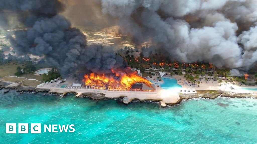
A huge fire at a luxury beach resort in the Dominican Republic killed one woman and forced nearly 1,700 guests to be evacuated on Friday.
The woman was a 46-year old Italian tourist, the DAEH emergency services said in a statement to local media. It added that three people were taken to medical facilities and six others were treated on site.
Drone footage shows how widespread the fire was, with buildings spanning the Viva Wyndham Dominicus Beach in the town of Bayahibe on fire, and thick black smoke billowing into the air.
The cause of the early-morning blaze is not yet known, but an initial investigation found the flames spread quickly due to wind conditions and the flammable thatched roofs on some buildings.
The country’s Emergency Operations Center (COE) said the fire had been brought under control and guests had been moved to other hotels.
Italian news agency Ansa reported that the Italian ambassador to the Dominican Republic met the deceased woman’s husband at the hospital. The embassy is helping around 285 Italian tourists who were staying at the resort or nearby, issuing emergency passports to those whose travel documents were destroyed in the fire and arranging flights home.
Bayahibe, a popular resort town on the Caribbean coast, is known for its clear blue waters and sandy beaches.
TravelNews
U.S.-Iran talks postponed as Vance cancels trip and Israel intensifies strikes in Lebanon
The first peace talks between the United States and Iran were postponed Friday, as Vice President JD Vance canceled his planned travel to Switzerland and intense new Israeli strikes in Lebanon cast doubts on the deal to end the war.
The escalation in Lebanon came just days after the interim U.S.-Iran agreement was signed and as the two sides were set to sit down for their first negotiations to agree a lasting conclusion to the conflict started by the U.S. and Israel in late February.
The White House did not give a reason for the cancelation of Vance’s trip to the Swiss Alps. The talks that had been planned for Friday were meant to launch a 60-day period of negotiations to resolve key long-term issues and ensure a permanent end to the war.
Switzerland’s foreign ministry confirmed early Friday that the planned talks between the U.S., Iran, Qatar and Pakistan would not take place in the mountaintop resort of Bürgenstock.
“Switzerland remains ready to facilitate these talks,” the ministry said in a statement, adding that “relevant preparatory work” in Bürgenstock is continuing.
A White House spokesperson said late Thursday that Vance would not be traveling to Switzerland.
“As the Vice President said at his press conference, the plans for the upcoming technical talks have not been finalized, and the U.S. delegation has been prepared to depart at the first available opportunity,” the spokesperson said. “But the logistics of these negotiations have never been simple or predictable. As of now the Vice President is not departing tonight.”
The spokesperson added, “We look forward to beginning technical talks as soon as possible.”
Speaking at the White House earlier Thursday, Vance stressed that Israel had to “respect this peace process that is fundamentally good for them and good for the entire region.”
He also addressed President Donald Trump’s public frustration with Israeli Prime Minister Benjamin Netanyahu, saying that Israeli strikes in Lebanon when they were “right on the cusp of a major breakthrough in the agreement” were “not acceptable.”
In Lebanon, Israel said it targeted Tehran-backed militant group Hezbollah across the south of the country overnight and early Friday, killing at least 18 people, Lebanese health officials reported.
The Israeli military said four of its soldiers were killed and another five injured as Hezbollah also reported fighting in the area.
There was no immediate reaction from Iranian officials, with the country’s state media reporting on the postponement of the talks but not laying out the reasons for it.
Iran has warned that it would not abide by the agreement should Israel, which was left out of the peace talks, continue its deadly campaign in Lebanon.
Iran’s Supreme Leader Mojtaba Khamenei said that Trump brought about the interim agreement “out of desperation.”
In a statement released Thursday night on Telegram, Khamenei said he “held a different view” on the memorandum of understanding, but gave his permission anyway, adding that Iran won’t submit to any “excessive” American demands.
“It is self-evident that the in-person negotiations that will take place in the future will not mean acceptance of the enemy’s position,” he added.
The interim agreement includes reopening the key Strait of Hormuz trading route, after months of disruption for the global economy.
Brent crude steadied Friday but remained set for a more than 8% weekly decline given news of the deal.
NBC News analysis of marine traffic through the crucial waterway revealed a slow trickle of ships travelling through the strait Thursday and into Friday, as two Chinese and two Hong Kong owned ships and a Japanese crude oil tanker left the Persian Gulf, where they had been stuck since February.
TravelNews
Live updates: Life-threatening flash flood emergencies ongoing as Arthur’s remnants slam South


2:48 PM ET Just NowBreaking News
Severe storms expand eastward: Tornado Watch issued until 11 p.m. ET for Atlanta and the Deep South
The threat of severe weather from Arthur’s volatile remnants is expanding eastward into the afternoon.
The Storm Prediction Center has issued a widespread Tornado Watch until 11:00 p.m. ET tonight, encompassing metropolitan Atlanta, a massive portion of southern Alabama, and the western Florida Panhandle.
As the center of the post-tropical low pressure system edges further inland, its outer feeder bands are tapping into an environment loaded with extreme tropical moisture and strong low-level atmospheric shear.
These conditions are highly favorable for the development of fast-moving, low-topped supercell thunderstorms.
Because these tropical storms pull directly from Gulf moisture, any spin-up tornadoes that develop will likely be heavily rain-wrapped and exceptionally difficult to spot visually until they are right on top of you.
Residents across the watch area—including major corridors along Interstate 85 in Georgia and Interstate 10 in Florida—are strongly urged to review their severe weather safety plans immediately.
Ensure you have multiple ways to receive warnings that can wake you up tonight, keep your mobile devices charged, and be ready to seek shelter in an interior room on the lowest floor of a sturdy building the moment a warning is issued for your area.
2:07 PM ET 41 Min Ago
See It, Share It: Help us document the historic scale of the Southern flood crisis
As a historic and life-threatening flash flood disaster grips the central Gulf Coast and expands across the Southeast, we need your help to safely document the sheer scale of this crisis.
If you are witnessing the ongoing flooding from a secure location, please upload your photos and videos here.
Your real-time visuals are incredibly vital. They help us show everyone the true magnitude of this catastrophic tropical deluge, keep communities informed, and aid forecasters tracking these rapidly shifting hazards.
1:51 PM ET 57 Min Ago
Analysis: Satellite reveals the engine behind Avoyelles Parish’s 2-foot historic deluge
Visible satellite imagery today is painting a stunning, albeit terrifying, picture that perfectly explains why torrential tropical thunderstorms have stubbornly refused to move over central Louisiana, leading to a truly historic disaster.
The high-resolution images reveal the exact atmospheric engine driving the catastrophic flooding in Avoyelles Parish and neighboring communities.
As the center of what is now post-tropical “ex-Arthur” ground slowly to the northeast, it set up a textbook zone of surface convergence directly over central Louisiana.
This convergence zone created a violent, invisible boundary where two completely opposing wind patterns collided from the North with cooler northwest winds on the backside of the low, and from the South with a ferocious, 45-to-60 mph low-level wind jet blowing directly ahead of the storm center.
Because those strong southerly winds were drawing straight from the ultra-warm waters of the Gulf of America, they acted as a non-stop, high-velocity atmospheric firehose, relentlessly pumping record-level tropical moisture right into the collision zone.
When that infinite moisture supply slammed into the opposing northwesterly winds, the air had nowhere to go but straight up.
Because this boundary has remained locked in place, it forced thunderstorms to continuously form, collapse, and reform over the exact same patches of land—a dangerous meteorological phenomenon known as backbuilding and training.
The math behind this setup is as simple as it is devastating: an unrelenting moisture feed combined with a stalled atmospheric boundary equals more than 2 feet of rain in less than 24 hours.
1:46 PM ET 1 HR AgoBreaking News
NWS New Orleans confirms a trio of EF-1 tornadoes slammed metro area
As if the historic, ongoing flash flooding wasn’t enough, the National Weather Service in New Orleans has confirmed that at least three separate tornadoes touched down across southeast Louisiana during Arthur’s severe weather blitz.
While meteorologists stress that these findings are preliminary and survey teams are still assessing the damage, the NWS has confirmed the following tracks and intensities:
Tornado #1 (Houma): Rated an EF-1 with peak estimated winds of 95 mph.
Tornado #2 (West Bank of Jefferson Parish): Rated an EF-1 with peak estimated winds of 90 mph.
Tornado #3 (East Bank of Jefferson and Orleans Parishes): Rated an EF-1 with peak estimated winds of 95 mph.
These fast-moving, rain-wrapped tropical vortices spun up quickly within Arthur’s intense outer convective bands. Even at EF-1 strength, winds nearing 100 mph are more than capable of snapping power poles, peeling roofing material off homes, flipping unanchored structures, and tossing heavy debris.
With survey crews still active in the field, it is highly possible that these track lengths may be extended or additional tornado touchdowns will be confirmed in the coming days.
1:34 PM ET 1 HR AgoBreaking News
Historic disaster: Flash Flood Emergency for Avoyelles Parish with up to 24 inches of rain
An absolute worst-case scenario is unfolding in Louisiana as the National Weather Service continues its Flash Flood Emergency for Southern Avoyelles Parish.
An unfathomable 12 to 24 inches of rain has already fallen across the region, completely overwhelming the landscape and triggering active, widespread emergency evacuations.
Meteorologists have classified this as a Particularly Dangerous Situation. Intense tropical training thunderstorms have essentially dropped two feet of water over areas that are completely incapable of draining it, forcing residents from their homes as water reaches catastrophic levels.
1:07 PM ET 1 HR Ago
“The drain on the corner just officially stopped”: Video captures flooding in Picayune
The true severity of the Flash Flood Emergency in Picayune, Mississippi, is hitting home on social media.
Local resident Angelina Rushing posted a distressing video to Facebook from the corner of West Canal Street, describing the exact moment the local storm drain simply stopped working minutes prior, causing water to instantly back up and inundate the area.
12:20 PM ET 2 HRS AgoBreaking News
Pinned
Weather Prediction Center expands rare Level 4 high risk flood threat deeper into Southeast
The ongoing, life-threatening flash flood disaster across the central Gulf Coast has forced meteorologists at the Weather Prediction Center to expand the rare Level 4 out of 4 “High Risk” zone today.
Short-range computer models and real-time radar data confirm a worst-case scenario is unfolding as repetitive bands of “backbuilding” storms—where intense rain continuously reforms over the exact same locations—have already dropped a staggering 9 to 11 inches of rain across parts of Louisiana and Mississippi.
The environment fueling these storms is historically volatile. The atmospheric engine is drawing directly from record-breaking tropical moisture levels (precipitable water values over 2 inches) and a ferocious 45-to-58 mph low-level wind jet pumping juice straight off the warm Gulf of America.
Because of this, forecasters have modified today’s risk map in two critical directions:
Westward expansion: Pushed deeper into central Louisiana, where a Flash Flood Emergency remains actively underway due to ongoing, catastrophic inundation.
Northeastward expansion: Expanded across southern Mississippi and Alabama, where high-resolution modeling warns that an additional 5 to 8+ inches of rain is highly probable.
The WPC notes this dangerous flood corridor will continue to expand deeper into the Southeast as the afternoon progresses.
Heightened life-safety concerns are now shifting dynamically into southwestern and central Georgia, as well as further north into the highly vulnerable terrain of the southern Appalachians.
If you are anywhere within this expanding bullseye, do not wait for water to enter your home—take action to protect your life immediately.
12:18 PM ET 2 HRS AgoBreaking News
Catastrophic flooding triggers Flash Flood Emergency in Stone County
The National Weather Service has issued a rare Flash Flood Emergency for Stone County, Mississippi until 4:15 p.m. CT this afternoon.
Local emergency management officials report that a catastrophic crisis is unfolding, with significant to major flooding occurring across the entire county, forcing active high-water rescue operations.
A staggering 6 to 10 inches of rain has already fallen, and with Arthur’s relentless tropical bands stalled over the area, an additional 3 to 6 inches of rain is highly likely.
Meteorologists have classified this as a Particularly Dangerous Situation. The ground is completely saturated, meaning any additional rainfall will instantly become dangerous, rushing runoff. People within the warning area are urged to seek higher ground immediately and strictly avoid all travel.
12:08 PM ET 2 HRS AgoBreaking News
I-59 closed in both directions as catastrophic floodwaters submerge Mississippi interstate
The Flash Flood Emergency in Pearl River County has triggered a major transportation crisis, forcing the total closure of Interstate 59 in both directions near Picayune.
Muddy floodwaters fueled by Arthur’s relentless tropical remnants have breached the highway, submerging all travel lanes under feet of water.
Mississippi Department of Transportation crews and state troopers have shut down the corridor, diverting all traffic off the interstate.
Officials warn that the highly unusual closure will remain in effect indefinitely until the training rain bands subside and water levels recede below the asphalt.
12:03 PM ET 2 HRS AgoBreaking News
Water rescues reported as catastrophic flooding paralyzes Avoyelles Parish
The escalating Flash Flood Emergency in Avoyelles Parish has reached a critical, life-threatening stage as torrential tropical rain from Arthur’s stalled remnants completely submerges towns across central Louisiana.
Local emergency services are stretched to their limits trying to manage a rapidly deteriorating crisis. In Mansura, the Louisiana Department of Transportation has officially shut down LA Highway 114, which has become completely impassable due to deep, fast-moving floodwaters swallowing the asphalt.
Conditions are equally dire to the east. Streets throughout Simmesport are entirely underwater, stranding residents and inundating yards as neighborhood drainage systems stand completely overwhelmed by the sheer volume of water.
The gravity of the situation was felt this morning in nearby Cottonport, where emergency dispatchers confirmed a high-water rescue operation had to be initiated to save individuals trapped by rapidly encroaching waters.
First responders are reiterating that all residents should remain safely on high ground and strictly avoid any travel, as conditions continue to worsen by the hour.
11:39 AM ET 3 HRS AgoBreaking News
Social media video captures alarming floodwaters submerging Highway 11 in Picayune
A startling video posted to Facebook by local resident Nayy Booth showcases the severe reality of the ongoing Flash Flood Emergency along the Gulf Coast, capturing deep, muddy floodwaters completely swallowing portions of US Highway 11 in Picayune.
The video highlights an increasingly dangerous travel environment as torrential downpours from Arthur’s remnants rapidly transform major thoroughfares into virtual rivers.
11:37 AM ET 3 HRS AgoDeveloping Story
Danger escalates in Picayune as new round of heavy rain targets flood emergency zone
The catastrophic situation in Picayune, Mississippi, is on the verge of deteriorating even further as the FOX Forecast Center tracks a new, heavy band of tropical downpours pushing directly into the city.
Picayune and wider Pearl River County are already paralyzed under a rare Flash Flood Emergency after a grueling 7 inches of rain fell in less than six hours earlier today.
The ground is completely maxed out and incapable of absorbing a single additional drop of water, meaning this incoming round of intense precipitation will instantly convert into dangerous, rushing surface runoff.
Emergency management officials are reiterating their urgent warnings for all residents to stay exactly where they are on high ground, as any attempt to travel through this next wave of water will put lives at severe risk.
11:28 AM ET 3 HRS Ago
On the ground in Biloxi: Brandy Campbell reports live from extreme flood risk zone
FOX Weather Correspondent Brandy Campbell is reporting live from Biloxi, Mississippi, where the coastal community is bracing for the brunt of Arthur’s remnants under a maximum Level 4 out of 4 excessive rain risk.
11:21 AM ET 3 HRS Ago
Traffic camera captures flooding on Highway 11 in Picayune
A live MDOT traffic camera on Mississippi Highway 11 captures a visual of the escalating crisis in Picayune this morning, showing floodwaters submerging portions of the busy thoroughfare.
With the city already paralyzed by nearly 7 inches of rain that fell in less than six hours, officials are monitoring these live cameras to track rapid water rises and are strongly imploring residents to stay home as emergency crews navigate the worsening deluge.
11:17 AM ET 3 HRS Ago
Understanding the ultimate flood danger: Why a flash flood emergency demands immediate action
A Flash Flood Emergency is the highest, most urgent alert issued by the National Weather Service, reserved exclusively for rare situations where catastrophic, life-threatening flooding is actively occurring.
Unlike a standard Flash Flood Warning—which means flooding is possible or developing—an Emergency is only triggered when severe flooding poses an immediate threat to human life or indicates a major structural disaster is underway, such as a dam failure or widespread water rescues.
When an Emergency is declared, it means infrastructure is failing, roads are completely submerged, and residents must take immediate, extraordinary action to protect their lives, such as moving to the highest floor of a building or seeking immediate high ground.
11:11 AM ET 3 HRS AgoBreaking News
Flash Flood Emergency declared for Pearl River County as life-threatening water inundates Picayune
The National Weather Service has issued a life-threatening Flash Flood Emergency for Pearl River County in southern Mississippi as the moisture-packed core of Arthur’s remnants stalls directly over the region.
Local emergency management officials report that catastrophic flooding is actively occurring, with multiple roads completely submerged, impassable, and hazardous to motorists.
A staggering 3 to 5 inches of tropical rain has already inundated the area this morning, and with the persistent feeder bands showing no signs of budging, forecasters warn that an additional 3 to 6 inches of rain is entirely possible through the afternoon.
Residents are being strongly urged to seek higher ground immediately and stay completely off local roadways, as rapidly rising waters are creating extremely dangerous conditions across the county.
11:04 AM ET 3 HRS AgoBreaking News
Flash Flood Emergency issued for Avoyelles Parish amid life-threatening water rises
The National Weather Service has issued a rare and life-threatening Flash Flood Emergency for Avoyelles Parish as the core of Arthur’s tropical remnants unloads catastrophic rain rates across central Louisiana.
Emergency officials report that relentless training thunderstorms have overwhelmed local drainage systems, causing rapid, severe water rises that are actively inundating roadways and threatening low-lying residential structures.
The FOX Forecast Center says rain is falling at 1-3 inches per hour with radar estimating more than a foot of rain has fallen in the past few hours.
9:44 AM ET 5 HRS Ago
Analysis: Where is Arthur now? Disorganized remnant low stalls over the Gulf Coast mud
The National Hurricane Center has officially written the final chapter on Arthur’s life cycle as a named tropical cyclone.
In its final advisory issued late Wednesday night, the NHC discontinued all coastal Tropical Storm Watches and Warnings after the system’s heavily sheared center erratically relocated over land near Galveston, Texas, and collapsed into a post-tropical remnant low pressure area with maximum sustained winds of 35 mph.
While its status as a tropical storm lasted less than 24 hours, the NHC’s parting message was a stark warning to the South: Arthur’s structural demise changes absolutely nothing about the sheer volume of water it is carrying.
Right now, Arthur’s decaying ghost is silently gliding northeastward over Mississippi.
Even though the low-level circulation is rain-free, the storm’s massive wind field is drawing significant amounts of moisture off the Gulf of America.
This setup has effectively parked an atmospheric firehose directly over Mississippi and Alabama, where intense tropical training bands will continue to dump torrential downpours through Friday.
Arthur may no longer be a tropical storm on paper, but its remnants are actively delivering the exact catastrophic, multi-day flood disaster that forecasters feared most.
9:29 AM ET 5 HRS AgoDeveloping Story
Tornado risk escalates across southern Mississippi and Alabama under Arthur’s feeder bands
The threat of dangerous, spin-up tornadoes is escalating across southern Mississippi and Alabama today as the volatile outer feeder bands of Arthur’s remnants drill into the Gulf Coast.
The FOX Forecast Center warns that intense atmospheric shear—the changing of wind speed and direction with height—is overlapping with a deeply unstable, moisture-rich tropical air mass pushing inland.
This combination will make it incredibly easy for rotating, low-topped supercell thunderstorms to spawn quick, fast-moving tornadoes with very little warning through the afternoon and evening hours.
Because these tropical twisters are often wrapped in torrential rain and difficult to see ahead of time, experts are urging residents from Biloxi to Mobile to keep their devices charged, have multiple ways to receive severe weather alerts, and review their emergency shelter plans immediately.
9:26 AM ET 5 HRS Ago
Multiple tornadoes tear through Mississippi as tropical bands trigger warnings
A volatile situation is unfolding across Mississippi right now as the severe outer feeder bands of Arthur’s remnants spawn multiple tornadoes simultaneously.
The National Weather Service has issued multiple Tornado Warnings with at least two confirmed twisters happening in the southern part of the state.
9:20 AM ET 5 HRS Ago
Dramatic video captures intense wind and blinding rain in Louisiana as Arthur roars through
Dramatic video captured early this morning in Montegut, Louisiana, showcases the ferocious power remaining in Arthur’s remnants as they pushed through the coastal bayou communities.
The video reveals blinding tropical downpours driving sideways under violent, howling wind gusts that slammed Terrebonne Parish well before sunrise.
9:15 AM ET 5 HRS Ago
Flash Flood Warning triggered for Hattiesburg with FOX Weather’s Haley Meier live on the ground
A dangerous situation is developing in Hattiesburg, Mississippi, which has just been placed under a Flash Flood Warning as downpours from Arthur’s remnants stall over the Pine Belt.
FOX Weather Meteorologist Haley Meier is reporting live from the ground, tracking downpours that are rapidly blinding drivers and pooling across major thoroughfares.
9:09 AM ET 5 HRS Ago
FOX Weather Threat Zone shows rare extreme area for Mississippi, Alabama, and Florida Panhandle
The FOX Forecast Center has taken the rare step of upgrading the FOX Weather Threat Zone to an “extreme” designation right along the Gulf Coast today.
This maximum threat area places coastal Mississippi, southern Alabama, and the western Florida Panhandle directly in the crosshairs for catastrophic flash flooding as Arthur’s tropical remnants stall.
9:05 AM ET 5 HRS Ago
Heavy rain bullseye tracks into Mississippi after swamping southern Louisiana
A relentless onslaught of tropical moisture from Arthur’s remnants has inundated southeastern Louisiana and southern Mississippi with staggering rain totals this morning.
The FOX Forecast Center reports that radar estimates show more than 8 inches of rain has already fallen in isolated spots south and west of New Orleans, forcing widespread flash flooding.
The core of the heaviest rain is now actively shifting eastward into southern Mississippi, where saturated ground will quickly trigger rapid water rises along roads and creeks through the afternoon.
8:29 AM ET 6 HRS Ago
Damage reported in Lakeshore Village as suspected tornado downs trees and power lines
A suspected tornado spun up by the outer bands of Arthur’s remnants has left a visible trail of destruction in the Lakeshore Village subdivision of Slidell, Louisiana.
Pictures on social media show snapped large trees, shredded backyard fences, and downed active utility lines across local streets.
Emergency crews are working to secure the area and clear the debris, while officials continue to urge locals to stay indoors and treat all downed wires as live.
8:25 AM ET 6 HRS Ago
Over 50,000 customers in the dark as Arthur’s remnants slam Texas and Louisiana
The brutal combination of torrential rain, tornadoes, and strong winds from Arthur’s remnants has knocked out power to tens of thousands of residents across the Gulf Coast this morning.
According to data from PowerOutage.com, nearly 40,000 customers are currently sitting in the dark across Louisiana, while more than 14,000 utility customers are experiencing outages in neighboring Texas.
Emergency crews are working to restore electricity as quickly as possible, though ongoing severe weather and flooded roadways are presenting significant challenges for line workers.
8:21 AM ET 6 HRS Ago
When high risk means ultimate danger: The chilling stats behind a Level 4 flood threat
When the Weather Prediction Center (NOAA) highlights a region in a Level 4 “High Risk” for excessive rain, it is a designation that should make everyone in its path stop what they are doing.
These alerts are not issued lightly; in fact, the Weather Prediction Center only triggers a Level 4 risk on roughly 4% of days out of the entire year nationwide.
It is the highest and most urgent tier on the flash flood threat scale, reserved exclusively for atmospheric setups that are primed to deliver historic, catastrophic rain rates capable of overwhelming modern infrastructure and completely shifting the terrain within hours.
The statistics behind these rare declarations are staggering. Data compiled by NOAA over an 11-year period reveals that while High Risk days happen just 4% of the time, they account for an astonishing 36% of all flood-related fatalities and 80% of all flood-related property damages in the United States.
A Level 4 alert essentially means meteorologists are no longer just forecasting generic roadway ponding—they are predicting major structural inundation, widespread water rescues, and life-threatening conditions.
8:14 AM ET 6 HRS Ago
‘Particularly Dangerous Situation:’ Large tornado moving through Slidell area this morning
The National Weather Service has issued a rare Particularly Dangerous Situation (PDS) Tornado Warning for St. Tammany Parish as a “large and extremely dangerous” tornado moves directly through the Slidell area.
A radar-confirmed tornado was tracked on radar pushing northeast at 25 mph, forcing immediate life-safety shelter orders for Pearlington and the Stennis Space Center.
8:09 AM ET 6 HRS AgoDeveloping Story
Analysis: Second act? Arthur’s remnants could attempt tropical redevelopment over the Atlantic
As if a high-level flood threat across the Deep South wasn’t enough, the weather system that refuses to quit could have a second act waiting in the wings.
The FOX Forecast Center is actively tracking the remnants of Arthur as the parent trough of low pressure crawls across the Southeast.
According to the National Hurricane Center, environmental conditions appear marginally conducive for some subtropical or tropical redevelopment on Friday or Saturday.
The entire system is projected to accelerate northeastward over the next 48 hours, eventually emerging off the East Coast of the United States and spilling out into the warm waters of the Western Atlantic Ocean.
While the possibility of Arthur’s atmospheric ghost reforming at sea is drawing the attention of meteorologists, forecasters emphasize that it changes nothing about the immediate, high-stakes threat on land.
Regardless of whether the system regains a tropical name or structure over the ocean this weekend, its current footprint remains incredibly dangerous.
The immediate focus stays locked on the massive shield of tropical moisture currently swamping the Southeast, where torrential downpours retain the full potential to unleash widespread, life-threatening flash flooding through the next day or two.
8:04 AM ET 6 HRS Ago
On the ground in Hattiesburg: Haley Meier warns of rapidly increasing flash flood risk
FOX Weather Meteorologist Haley Meier is reporting live from the ground in Hattiesburg, Mississippi, this morning, where a high-risk flood threat is rapidly unfolding.
You can watch Haley Meier reporting on the severe weather threat all day on FOX Weather to see how the situation unfolds.
8:01 AM ET 6 HRS Ago
Spin-up tornadoes possible as tropical outer bands lash Gulf Coast and Southeast
While devastating flash flooding remains the primary hazard from Arthur’s remnants, the storm system is packing an extra punch with a persistent tornado threat across the Deep South today.
The Storm Prediction Center has outlined a severe weather risk area spanning southeastern Louisiana, southern and central Mississippi, Alabama, and parts of the Florida Panhandle.
As a weak surface low and atmospheric wave pull deep tropical moisture into the region, the wind field is ramping up significantly.
This high amount of low-level wind shear colliding with very sticky, mid-70s dewpoints will create an environment where rotating supercell thunderstorms can easily spin up tornadoes with little warning.
The risk is expected to peak through this afternoon and into early tonight as peak daytime heating maximizes atmospheric instability, making it critical for residents to keep their phones charged and weather alerts turned on.
7:50 AM ET 6 HRS Ago
Emergency crews assess damage after possible tornado strikes New Orleans metro
Emergency officials are on the ground assessing damage this morning after a suspected tornado spun up in the outer bands of Arthur’s remnants, tearing through parts of the New Orleans metro area.
The FOX Forecast Center reports that the fast-moving storm showed significant rotation as it pushed past New Orleans International Airport and neighboring communities just before dawn, triggering urgent Tornado Warnings across Jefferson and St. Charles parishes.
While the immediate threat has shifted eastward, crews are currently navigating heavily flooded streets to clear downed trees, check on ruptured power lines, and survey structural damage in the hardest-hit neighborhoods.
7:44 AM ET 7 HRS Ago
Flash Flood Warning issued for New Orleans metro as Arthur’s remnants swamp the city
A Flash Flood Warning has been issued for the New Orleans metro area as a brutal, slow-moving band of tropical thunderstorms slams southeastern Louisiana this morning.
The FOX Forecast Center notes that radar estimates show more than 5 inches of rain has already inundated areas just west of downtown, with rain rates pounding the pavement at an astonishing 2 to 4 inches per hour.
With the city’s drainage infrastructure being pushed to its absolute absolute limits by Arthur’s moisture, residents are strongly urged to stay off the roads, avoid low-lying underpasses, and monitor localized rising water immediately.
7:39 AM ET 7 HRS AgoDeveloping Story
Remnants of Arthur trigger extreme flood threat across the South with a foot of rain possible
Right now, the Deep South is bracing for a highly dangerous, multi-day weather event as the relentless remnants of Arthur tap into a powerhouse combination of Pacific and Gulf moisture.
The FOX Forecast Center says a rare Level 4 out of 4 high risk for flash flooding has been issued for Thursday, followed by a Level 3 risk on Friday, signaling that widespread and locally catastrophic flooding is likely.
The atmospheric plume is loading up a corridor from eastern Texas all the way to Georgia, putting millions of people directly in the crosshairs.
Flood Watches blanket major metro areas including New Orleans, Baton Rouge, Jackson, Montgomery, and Atlanta, where the ground is fast approaching a breaking point.
While a broad swath of the South can expect a general 5 to 8 inches of rain, the bullseye sitting over Louisiana, Mississippi, and Alabama is tracking a much more severe threat. A broad corridor through these states is likely to see 8 to 12 inches of rain, with localized totals easily carving past a foot where the heaviest tropical rainbands stall.
TravelNews
8 Questions and Demands We Have for ‘Widow’s Bay’ Season 2
In just a short amount of time, Widow’s Bay became our entire personality. We can’t stop quoting it or praising its wonderfully weird characters or wishing we could actually travel there, even with all its inherent perils.
With the season finale now out in the world and the big news that a second season is on the way, we’re now going down the rabbit hole with all the pieces of Widow’s Bay that will continue to haunt us until new episodes arrive.
1. What’s in Tom’s basement?
When Evan and Kelly snoop in Tom’s room, they discover a locked box full of family photos and creepy letters penned by Evan’s late mother, Lauren. When Tom realizes Evan has found a photo that proves Lauren didn’t exactly die in childbirth, as he’s always maintained, the first thing he blurts out is, “You went through the basement?”
No, Tom, Evan did not go in the basement. And neither did we. What other secrets are hidden down there, exactly?
2. Will Tom come clean to Evan about why he can’t leave the island?
Evan now understands that Lauren lived for a few years past his birth, though her health was severely impaired. However, Tom didn’t tell his son that Lauren was healthy until that fateful ferry ride. And he hasn’t told Evan that the island’s curse means that anybody who was born there can never leave.
There’s that brief flicker of hope after Richard Warren crumbles into dust and Tom buys the Red Sox tickets, thinking all his problems are solved. But with the reveal of Evan’s unfortunate lineage in the season one finale, it seems Evan’s chances of ever seeing the mainland are pretty grim.
Given the tension that we’ve seen between these two, it feels like Tom needs to tell Evan the whole truth. Not just that he can’t physically cross that Widow’s Bay perimeter, but also the reason why and his unique connection to it all. Will he, though?
3. Will anyone else find out about Evan? (Related: did Ruth survive her gunshot wound?)
Here’s where the big bloodline situation stands at the end of season one:
Wyck, Tom, Patricia, Rosemary, and Bechir know Ruth is descended from Richard Warren. (To our knowledge, Ruth does not know.)
But only Tom and Bechir (because Tom told him) know Ruth is not the last Warren descendent.
We can assume Bechir will keep prodding Tom for the truth. But will Ruth, who seemed so relieved to tell Tom about being Lauren’s “secret mommy,” agree to keep their family ties under wraps?
If Ruth even survived being shot by Bechir, that is? She opened her eyes, but… elderly woman, prescription drug overdose, apparent head wound, isolated island with limited medical facilities after a major storm—the odds aren’t great. (Why else would Tom have Sarah Warren’s brooch, Ruth’s precious family heirloom, to toss into the sea at the end of the finale?)
4. Eight more people have to be sacrificed, right?
Thanks to Dale finding the “FOR YOU” film in the emergency shelter, we learn that the island demands “one soul for each bell toll.”
This ties back to the Reverend Bryce’s earlier surprise when Tom said he heard the church bells ring. As the show is careful to show us, the bells are securely chained. They can’t ring on their own.
Bryce scours his office for guidance and finds instructions that read, in part, “should the bell toll, there are steps you must take,” directing him to a chamber “on the north side of the rectory.” (Because of the way the shot is framed, we can’t read the rest of what’s on the page.)
After that, he visits Todd, aka Shaman, and takes the mushrooms; presumably the island then communicates more specific instructions. We see him find the well with the ladder (later seen in “Our History”) in episode three. Whatever Bryce figures out is enough for him to take his own life rather than engage any further.
That much is clear. And we obviously understand the purpose of the chamber tucked beneath the emergency shelter with the spooky chair and menacing doors.
At the very end of “We Hope You Enjoyed Your Time!” we hear the bells ring eight times. That matches up with the eight people we know of who died throughout season one (Shep, Bryce, Richard Warren, the Boogeyman and his two victims, Todd the shaman, and Kenny).
However, what doesn’t make sense is the timing. Why is the island ringing the bells at the end of its cycle? Is it saying, “Thanks for the eight tasty souls; see you next time”? Nope. Here’s what we think.
If you’ll recall, at the start of episode two, “Lodging,” we hear the bells ring nine times. Nine souls. Kenny’s death in the sacrificial chamber counts toward the nine; the other deaths don’t. When the storm stopped as soon as Kenny got taken, that was just a temporary pause.
We think the eight tolls in episode 10 are the island making it crystal clear: it’s still feeding time. There are still eight more sacrifices to go, and they must pass through the creepy chair room.
Complicating matters, Richard Warren, who made the original bargain, kept things pretty secretive between himself and “that which keeps us alive.” However, he did shout out some important information as the villagers were burying him. The pact must be honored, you can speak to the entity “through the mushrooms,” and it requires sacrificing “life for life.” Otherwise, “the terrors will not cease.”
Did the pastor that Sarah Warren asked for help back in 1702 follow up on that and take his own mushroom trip? Someone must have traveled that path and transcribed the instructions that Bryce found in his office. But who?
5. Why don’t any of the Widow’s Bay lifers seem to know about the human sacrifices?
Think of another famous cursed island, Wicker Man’s Summerisle. The police officer lured there from the mainland doesn’t realize he’s about to be served up to ensure a robust harvest, but the locals are 100% in on the plan. That’s not the case in Widow’s Bay, where the characters seemingly have no clue about their own gruesome tradition.
To our knowledge, Bryce is the sole person with any information about it, which he only finds after rummaging through the papers in his office. That seems odd on an island full of crusty old-timers who seem to know a lot about its distressing history.
In the season premiere, when Wyck is warning Tom that “it’s starting” and that there will be disasters to come, he has a lot of institutional knowledge about what to expect. But he also says he doesn’t have all the information “because this town has its secrets.”
Who’s keeping those secrets? Neither Rosemary (gossip extraordinaire) nor Gerrie (town historian) seems aware of the human sacrifices. Thanks to the “FOR THEM” film, we know the victims were chosen not by an individual but rather by a committee.
What happened to the chain of information? At the museum we learn Widow’s Bay is home to 3,000 people. Did all the insiders happen to perish in one of those unfortunate accidents the island is so famous for?
And another thing: who shot the films that Dale finds in the finale? When exactly were they made? Why did they feel the need to produce instructional videos for the participants—and what’s the identity of the creepily chipper host?
6. What is the island’s slumber cycle—and can we please flash back to more disasters?
Widow’s Bay has a delightful habit of referencing catastrophes from the island’s past. However, it feels like the supernaturally active times don’t really occur on a cycle; it isn’t like Pennywise reliably emerging from the sewers every 27 years.
There was the deadly storm in 1786 that infamously led to cannibalism. The 1846 “fog that stole souls.” The witch trials, date unknown, which are still a great source of local pride. The “revenants of doomed sailors” thing that happened with the ghost ship in 1873.
There are also many horrors associated with the Breakwater Inn; we met the “Clown Killer of 1951,” but what about the New Year’s Eve disaster of 1962 (something Widow’s Bay creator Katie Dippold has mentioned as possible spinoff material) or the massacre in the captain’s suite? And “Ugly Hortence,” who could forget her?
And what was the deal with the teeth the first settlers found when they arrived? What happened to the 43rd settler?
We loved the 1702 flashback, both for the important details it brought to the story and because it was a lot of fun to see Widow’s Bay amid one of its ghastly vintage struggles. That was certainly no ordinary plague. More like this, please!
7. More exploration of Widow’s Bay itself
We saw a lot of the harbor area, the downtown, and some of the residential streets. But it would be fun to explore more. The abandoned hospital—the “Old Home,” where Lauren spent her final years—certainly seems intriguing, especially when Rosemary’s over here saying, “It’s perfectly safe to drive by the old hospital. You just can’t stop.”
What other freaky, forgotten sorts of places are there? We imagine there’s something unnerving lurking on every block, and we want to see it all.
We’re also curious to learn more about what the outside world makes of Widow’s Bay. The New York Times travel article brought a lot of tourists over from the mainland, and those visitors no doubt returned home full of colorful stories. Might more newcomers arrive to shake up the status quo, in ways both good and bad, in season two?
8. More Rosemary and Dale!
We loved the Patricia episodes. We want even more Patricia in season two; we need to see her paintings and read that poem we heard so much about.
But we’d also love to see more of the other town hall weirdos come to the fore. Rosemary and Dale bottle episode! Maybe throw some Kathy in there too! Make it happen, Widow’s Bay season two! (Katie Dippold has said she’s planning on it, so we have our hopes sky high.)
What do you hope to see from Widow’s Bay season two? Are there elements you hope the show leaves deliberately unexplained? Do you have any clarity or fan theories to add to the above? Sound the siren and join in the comments below.
Want more io9 news? Check out when to expect the latest Marvel, Star Wars, and Star Trek releases, what’s next for the DC Universe on film and TV, and everything you need to know about the future of Doctor Who.


Police fatally shoot l 1-year-old outside Mississippi Walmart
Witness video shows the moments after a law enforcement officer shot at a car in a parking lot outside a...


From Jennifer Aniston to Keke Palmer: All Off the Set S2 moments | Variety & CNN Actors on Actors
From breakout stars to Hollywood legends, this supercut brings together Season 2 of Actors on Actors' Off the Set in...


Vance to head to Switzerland for Iran talks
Vice President JD Vance is expected to travel to Switzerland for the US-Iran talks as fighting in Lebanon brings uncertainty...


Intense flooding hits Gulf Coast states
Videos show the aftermath of heavy flooding across the Gulf Coast and the southern United States due to Tropical Storm...


Blake Lively Steps Out Alone in New York Amid Taylor Swift’s Bachelorette Buzz
Blake Lively’s staying solo this weekend … hanging out alone while Taylor Swift’s surrounded by friends at her Rhode Island...


Claude Guillemot, co-founder of video game maker Ubisoft, dies in plane crash
A founder of global gaming company Ubisoft, maker of Assassin’s Creed, was killed in a plane crash in western France,...


‘Toy Story 5’ Headed to $160M Biggest Opening of 2026
Disney and Pixar are unwrapping a major box office gift with Toy Story 5, which is headed toward the biggest...


Fight or Go? Keir Starmer Considers His Next Move | BBC Newscast
Insiders have told Laura Kuenssberg that the Foreign Secretary Yvette Cooper has joined a list of people who've told Keir...


President Trump unveils Qatari luxury jet for Air Force One fleet. #Qatar #US #AirForceOne #BBCNews


Jimmy Kimmel taps longtime Trump nemesis Rosie O’Donnell to replace him as he steps back from late-night show
Jimmy Kimmel announced comedian Rosie O’Donnell will be temporarily taking over his late-night show as he steps back for a...
-

 Business1 week ago
How much of Musk’s wealth comes from government help? Virtually all of it
-

 Politics1 week ago
What to know about the stabbing that set off fiery riots in Northern Ireland
-

 Video1 week ago
Download fans say what they love about the festival. #DownloadFestival #BBCNews
-

 Video1 week ago
Why SpaceX IPO isn't about space. #SpaceX #ElonMusk #BBCNews
-

 HealthNews1 week ago
The people of Okinawa, Japan only eat until they are about 80 percent full, then stop — and the practice has been linked in multiple peer-reviewed studies to lower rates of cardiovascular disease, slo
-

 Food1 week ago
Pope Leo’s plane was grounded. Then the King of Spain stepped in to help
-

 TravelNews1 week ago
My Paternal Instinct Should’ve Warned Me About Netflix’s Maternal Instinct
-

 Video1 week ago
Claire Danes has the cutest stories about young Kirsten Dunst on 'Little Women' set